

plate, the lithospheric bulge, can be observed in the variations of altitude of the uplifted atolls of the Loyauté islands
(Dubois et al., 1974, 1975; Guyomard et al., 1996). Globally, it appears that the morphology and the distribution of
coral reefs in New Caledonia highly depend on the vertical
motions (Chevalier, 1968; Cabioch et al., 1996) so that
their morphological studies and the coral datation provide
data on the neotectonics in the Late Quaternary. In this
way, the study of the variations in depth or altitude of
the 125 ka (1 ka = 1,000 years) reefs (generally expected
at þ6 m above the modern sea surface) and the modern
reefs documents on the differential vertical movements
and the recent motion rates. The overall setting of the 125
ka reef around New Caledonia shows an irregular increasing island subsidence tendency northward and southwestward from a relatively more or less central zone
(Cabioch et al., 1996). For instance, Frank et al. (2006)
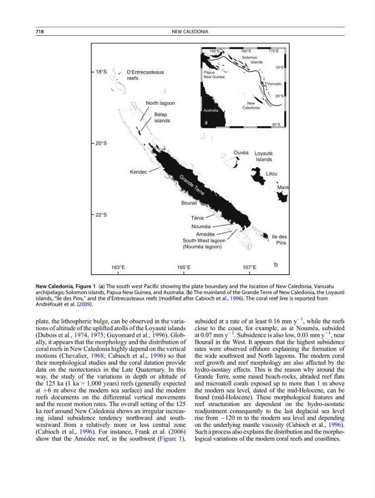
show that the Amédée reef, in the southwest (Figure 1),
subsided at a rate of at least 0.16 mm y
À1
, while the reefs
close to the coast, for example, as at Nouméa, subsided
at 0.07 mm y
À1
. Subsidence is also low, 0.03 mm y
À1
, near
Bourail in the West. It appears that the highest subsidence
rates were observed offshore explaining the formation of
the wide southwest and North lagoons. The modern coral
reef growth and reef morphology are also affected by the
hydro-isostasy effects. This is the reason why around the
Grande Terre, some raised beach-rocks, abraded reef flats
and microatoll corals exposed up to more than 1 m above
the modern sea level, dated of the mid-Holocene, can be
found (mid-Holocene). These morphological features and
reef structuration are dependent on the hydro-isostatic
readjustment consequently to the last deglacial sea level
rise from À120 m to the modern sea level and depending
on the underlying mantle viscosity (Cabioch et al., 1996).
Such a process also explains the distribution and the morphological variations of the modern coral reefs and coastlines.
Loyauté
Islands
Ile des
Pins
Maré
Lifou
Ouvéa
150°E
160°E
170°E
30°S
20°S
10°S
Australia
New
Caledonia
V A N U A T U
TR
E
N C H
Solomon
Islands
Vanuatu
Papua
New Guinea
a
b
163°E
165°E
167°E
22°S
20°S
18°S
D'Entrecasteaux
reefs
Bélep
islands
Ténia
South-West lagoon
(Nouméa lagoon)
North lagoon
Kendec
Amédée
Bourail
Nouméa
G r a n d e T e r r e
New Caledonia, Figure 1 (a) The south west Pacific showing the plate boundary and the location of New Caledonia, Vanuatu
archipelago, Solomon islands, Papua New Guinea, and Australia. (b) The mainland of the Grande Terre of New Caledonia, the Loyaute ´
islands, “ı ˆle des Pins,” and the d’Entrecasteaux reefs (modified after Cabioch et al., 1996). The coral reef line is reported from
Andre ´foue ¨t et al. (2009).
718
NEW CALEDONIA