

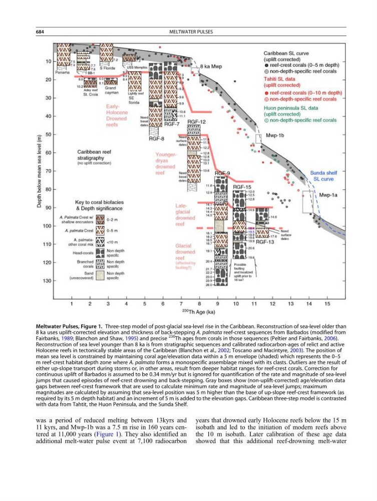
was a period of reduced melting between 13kyrs and
11 kyrs, and Mwp-1b was a 7.5 m rise in 160 years centered at 11,000 years (Figure 1). They also identified an
additional melt-water pulse event at 7,100 radiocarbon
years that drowned early Holocene reefs below the 15 m
isobath and led to the initiation of modern reefs above
the 10 m isobath. Later calibration of these age data
showed that this additional reef-drowning melt-water
Meltwater Pulses, Figure 1. Three-step model of post-glacial sea-level rise in the Caribbean. Reconstruction of sea-level older than
8 ka uses uplift-corrected elevation and thickness of back-stepping A. palmata reef-crest sequences from Barbados (modified from
Fairbanks, 1989; Blanchon and Shaw, 1995) and precise
230 Th ages from corals in those sequences (Peltier and Fairbanks, 2006).
Reconstruction of sea level younger than 8 ka is from stratigraphic sequences and calibrated radiocarbon-ages of relict and active
Holocene reefs in tectonically stable areas of the Caribbean (Blanchon et al., 2002; Toscano and Macintyre, 2003). The position of
mean sea level is constrained by maintaining coral age/elevation data within a 5 m envelope (shaded) which represents the 0–5
m reef-crest habitat depth zone where A. palmata forms a monospecific assemblage mixed with its clasts. Outliers are the result of
either up-slope transport during storms or, in other areas, result from deeper habitat ranges for reef-crest corals. Correction for
continuous uplift of Barbados is assumed to be 0.34 mm/yr but is ignored for quantification of the rate and magnitude of sea-level
jumps that caused episodes of reef-crest drowning and back-stepping. Gray boxes show (non-uplift-corrected) age/elevation data
gaps between reef-crest framework that are used to calculate minimum rate and magnitude of sea-level jumps; maximum
magnitudes are calculated by assuming that sea-level position was 5 m higher than the base of up-slope reef-crest framework (as
required by its 5 m depth habitat) and an increment of 5 m is added to the elevation gaps. Caribbean three-step model is contrasted
with data from Tahtit, the Huon Peninsula, and the Sunda Shelf.
684
MELTWATER PULSES