

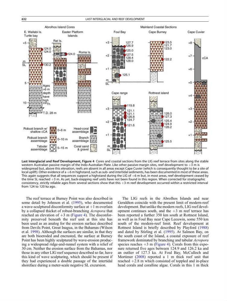
The reef terrace at Burney Point was also described in
some detail by Johnson et al. (1995), who documented
a wave-sculptured disconformity surface at þ1 m overlain
by a collapsed thicket of robust-branching Acropora that
reached an elevation of þ3 m (Figure 4). The disconformity preserved beneath the reef unit at this site has
been used as an analog for the erosion surface described
from Devils Point, Great Inagua, in the Bahamas (Wilson
et al. 1998). Although the surfaces are similar, in that they
are both bioeroded and encrusted, the surface at Burney
Point has been highly sculptured by wave-erosion producing a widespread ridge-and-runnel system with a relief of
30 cm. Neither the erosion surface from the Bahamas, nor
those in any other LIG reef sequence described so far, have
this kind of wave sculpturing, which should be present if
they had experienced a double passage of the intertidal
shoreface during a meter-scale negative SL excursion.
The LIG reefs in the Abrolhos Islands and near
Geraldton coincide with the present limit of modern-reef
development. But unlike the modern reefs, LIG reef development continues south, and the þ3 m reef terrace has
been reported a further 350 km south at Rottnest Island,
as well as in Foul Bay near Cape Leeuwin, some 550 km
south of the modern-reef limit. Reef development at
Rottnest Island is briefly described by Playford (1988)
and dated by Stirling et al. (1995). At Salmon Bay, on
the south coast of the Island, a coastal exposure of reef
framework dominated by branching and tabular Acropora
species reaches þ3 m (Figure 4). Corals from this exposure returned five ages between 124.9 and 126.2 ka and
an outlier of 127.3 ka. At Foul Bay, McCulloch and
Mortimer (2008) reported a 1 m thick reef unit that
reached þ2.8 m which consisted of toppled and in-place
head corals and coralline algae. Corals in this 1 m thick
Last Interglacial and Reef Development, Figure 4 Cores and coastal sections from the LIG reef terrace from sites along the stable
western Australian passive margin of the Indo-Australian Plate. Like other passive-margin sites, reef development to þ3 m is
widespread but, above this elevation, reefs are absent in all areas except Cape Cuvier (which is consequently thought to be a site of
local uplift). Other evidence of a þ6 m highstand, such as sub- and intertidal sediments, has been documented in most of these areas.
This again suggests that all sequences support a highstand during the LIG of þ6 m but, in most areas, reef development ceased by
the time SL reached þ3 m. As yet, back-stepping reef units have not been found in this region. When corrected for stratigraphic
consistency, strictly reliable ages from several sections show that this þ3 m reef development occurred within a restricted interval
from 124 to 120 ka ago.
632
LAST INTERGLACIAL AND REEF DEVELOPMENT