

Enewetak Marine Biological Laboratory
After the initial operations crossroads nuclear tests at
Bikini Atoll were completed in 1946, considerable civilian-based research on the geology, oceanography, and
ecology of atoll ecosystems was encouraged alongside
military-applied research focusing on the impact of the
nuclear weapons and movement of radioactivity within
food webs of the atoll and marine ecosystems. Much of
this was funded by the Office of Naval Research and the
fledgling Atomic Energy Commission (AEC). A Pacific
Science Board of the National Academies of Science
was established, and many top scientists and engineers
were engaged in research including those at the U.S. Geological Survey, Lawrence Livermore National Laboratory,
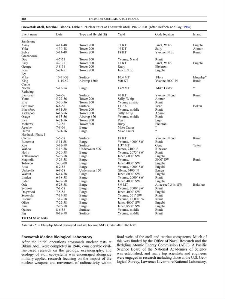
Enewetak Atoll, Marshall Islands, Table 1 Nuclear tests at Enewetak Atoll, 1948–1958. (After Helfrich and Ray, 1987)
Event name
Date
Type and Height (ft)
Yield
Code location
Island
Sandstone
X-ray
4-14-48
Tower 200
37 KT
Janet, W tip
Engebi
Yoke
4-30-48
Tower 200
49 KT
Sally
Aomon
Zebra
5-14-48
Tower 200
18 KT
Yvonne, N tip
Runit
Greenhouse
Dog
4-7-51
Tower 300
Yvonne, N end
Runit
Easy
4-20-51
Tower 300
47 KT
Janet, W tip
Engebi
George
5-8-51
Tower 200
Ruby
Eleleron
Item
5-24-51
Tower 200
Janet, N tip
Engebi
Ivy
Mike
10-31-52
Surface
10.4 MT
Flora
Elugelap*
King
11-15-52
Airdrop 1500
500 KT
Yvonne 2000’ N
Runit
Castle
Nectar
5-13-54
Barge
1.69 MT
Mike Crater
*
Redwing
Lacrosse
5-4-56
Surface
40 KT
Yvonne, N end
Runit
Yuma
5-27-56
Tower 200
Sally, W tip
Aomon
Erie
5-30-56
Tower 300
Yvonne airstrip
Runit
Seminole
6-6-56
Surface
13.7 KT
Irene
Boken
Blackfoot
6-11-56
Tower 200
Yvonne, middle
Runit
Kickapoo
6-13-56
Tower 300
Sally, N tip
Aomon
Osage
6-15-56
Airdrop 670
Yvonne, middle
Runit
Inca
6-21-56
Tower 200
Pearl
Lujor
Mohawk
7-2-56
Tower 300
Ruby
Eleleron
Apache
7-8-56
Barge
Mike Crater
*
Huron
7-21-56
Barge
Mike Crater
*
Hardtack, Phase I
Cactus
5-5-58
Surface
18 KT
Yvonne, N end
Runit
Butternut
5-11-58
Barge
Yvonne, 4000’ SW
Runit
Koa
5-12-58
Surface
1.37 MT
Gene
Teiter
Wahoo
5-16-58
Underwater 500
James, 7400’ S
Ribewon
Holly
5-20-58
Barge
Yvonne, 2075’ SW
Runit
Yellowwood
5-26-58
Barge
Janet, 6000’ SW
Engebi
Magnolia
5-26-58
Barge
Yvonne,
3000’ SW
Runit
Tobacco
5-30-08
Barge
Janet, 4000’ SW
Engebi
Rose
6-2-58
Barge
Yvonne, 4000’ SW
Engebi
Umbrella
6-8-58
Underwater 150
Glenn, 7400’ N
Ikuren
Walnut
6-14-58
Barge
Janet, 6000’ SW
Engebi
Linden
6-18-58
Barge
Yvonne, 2000’ SW
Runit
Elder
6-27-58
Barge
Janet, 4000’ SW
Engebi
Oak
6-28-58
Barge
8.9 MT
Alice reef, 3 mi SW
Bokoluo
Sequoia
7-1-58
Barge
Yvonne, 2000’ SW
Runit
Dogwood
7-5-58
Barge
Janet, 4000’ SW
Engebi
Scaevola
7-14-58
Barge
Yvonne, 561’ SW
Runit
Pisonia
7-17-58
Barge
Yvonne, 12,000’ W
Runit
Olive
7-22-58
Barge
Janet, 4000’ SW
Engebi
Pine
7-26-58
Barge
Janet, 8500’ SW
Engebi
Quince
8-6-58
Surface
Yvonne, middle
Runit
Fig
8-18-58
Surface
Yvonne, middle
Runit
TOTALS: 43 tests
Asterisk (*) = Elugelap Island destroyed and site became Mike Crater after 10-31-52.
384
ENEWETAK ATOLL, MARSHALL ISLANDS
After the initial operations crossroads nuclear tests at
Bikini Atoll were completed in 1946, considerable civilian-based research on the geology, oceanography, and
ecology of atoll ecosystems was encouraged alongside
military-applied research focusing on the impact of the
nuclear weapons and movement of radioactivity within
food webs of the atoll and marine ecosystems. Much of
this was funded by the Office of Naval Research and the
fledgling Atomic Energy Commission (AEC). A Pacific
Science Board of the National Academies of Science
was established, and many top scientists and engineers
were engaged in research including those at the U.S. Geological Survey, Lawrence Livermore National Laboratory,
Enewetak Atoll, Marshall Islands, Table 1 Nuclear tests at Enewetak Atoll, 1948–1958. (After Helfrich and Ray, 1987)
Event name
Date
Type and Height (ft)
Yield
Code location
Island
Sandstone
X-ray
4-14-48
Tower 200
37 KT
Janet, W tip
Engebi
Yoke
4-30-48
Tower 200
49 KT
Sally
Aomon
Zebra
5-14-48
Tower 200
18 KT
Yvonne, N tip
Runit
Greenhouse
Dog
4-7-51
Tower 300
Yvonne, N end
Runit
Easy
4-20-51
Tower 300
47 KT
Janet, W tip
Engebi
George
5-8-51
Tower 200
Ruby
Eleleron
Item
5-24-51
Tower 200
Janet, N tip
Engebi
Ivy
Mike
10-31-52
Surface
10.4 MT
Flora
Elugelap*
King
11-15-52
Airdrop 1500
500 KT
Yvonne 2000’ N
Runit
Castle
Nectar
5-13-54
Barge
1.69 MT
Mike Crater
*
Redwing
Lacrosse
5-4-56
Surface
40 KT
Yvonne, N end
Runit
Yuma
5-27-56
Tower 200
Sally, W tip
Aomon
Erie
5-30-56
Tower 300
Yvonne airstrip
Runit
Seminole
6-6-56
Surface
13.7 KT
Irene
Boken
Blackfoot
6-11-56
Tower 200
Yvonne, middle
Runit
Kickapoo
6-13-56
Tower 300
Sally, N tip
Aomon
Osage
6-15-56
Airdrop 670
Yvonne, middle
Runit
Inca
6-21-56
Tower 200
Pearl
Lujor
Mohawk
7-2-56
Tower 300
Ruby
Eleleron
Apache
7-8-56
Barge
Mike Crater
*
Huron
7-21-56
Barge
Mike Crater
*
Hardtack, Phase I
Cactus
5-5-58
Surface
18 KT
Yvonne, N end
Runit
Butternut
5-11-58
Barge
Yvonne, 4000’ SW
Runit
Koa
5-12-58
Surface
1.37 MT
Gene
Teiter
Wahoo
5-16-58
Underwater 500
James, 7400’ S
Ribewon
Holly
5-20-58
Barge
Yvonne, 2075’ SW
Runit
Yellowwood
5-26-58
Barge
Janet, 6000’ SW
Engebi
Magnolia
5-26-58
Barge
Yvonne,
3000’ SW
Runit
Tobacco
5-30-08
Barge
Janet, 4000’ SW
Engebi
Rose
6-2-58
Barge
Yvonne, 4000’ SW
Engebi
Umbrella
6-8-58
Underwater 150
Glenn, 7400’ N
Ikuren
Walnut
6-14-58
Barge
Janet, 6000’ SW
Engebi
Linden
6-18-58
Barge
Yvonne, 2000’ SW
Runit
Elder
6-27-58
Barge
Janet, 4000’ SW
Engebi
Oak
6-28-58
Barge
8.9 MT
Alice reef, 3 mi SW
Bokoluo
Sequoia
7-1-58
Barge
Yvonne, 2000’ SW
Runit
Dogwood
7-5-58
Barge
Janet, 4000’ SW
Engebi
Scaevola
7-14-58
Barge
Yvonne, 561’ SW
Runit
Pisonia
7-17-58
Barge
Yvonne, 12,000’ W
Runit
Olive
7-22-58
Barge
Janet, 4000’ SW
Engebi
Pine
7-26-58
Barge
Janet, 8500’ SW
Engebi
Quince
8-6-58
Surface
Yvonne, middle
Runit
Fig
8-18-58
Surface
Yvonne, middle
Runit
TOTALS: 43 tests
Asterisk (*) = Elugelap Island destroyed and site became Mike Crater after 10-31-52.
384
ENEWETAK ATOLL, MARSHALL ISLANDS