

refract and accommodate themselves to the reef front.
Instead, around the reef perimeter except at the windward
tip, they pass over the reef crest at a slight angle, leading
to a zone of wave convergence toward the leeward reef
flat. This is indicated clearly by the pattern of the aligned
coral zone (see Geomorphic Zonation) on many reefs.
However, centripetal transport and concentrated deposition are not developed on all reefs. Reef shape
is critical, as it controls the pattern of refraction. Convergence of wave trains is most likely on oval reefs. However, interference of wave patterns by upwind reefs may
mean that the waves approaching a reef are already
refracted. In these circumstances, a clear focal point from
further refraction may not be achieved, impeding island
formation.
The second important feature of waves is their ability to
transport sediment. Much wave energy is dissipated on the
reef edge due to breaking and reflection. However, some
energy is transmitted and smaller waves reform beyond
the break point and move over the reef, where they are
attenuated very slowly, unless water depths are exceptionally shallow or the bottom is very rough. The competency
of reformed waves to move sediment is markedly diminished, even during major storms. Thus, coarse sediment
is likely to be deposited on the windward margin where
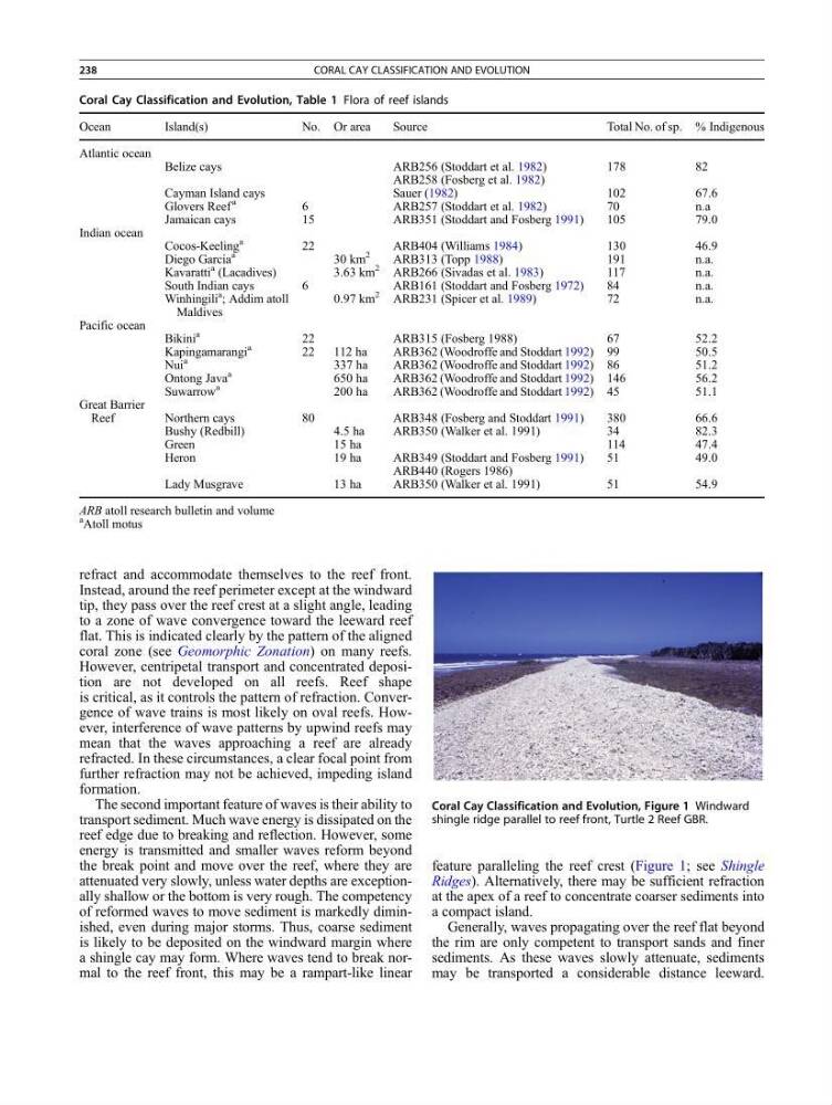
a shingle cay may form. Where waves tend to break normal to the reef front, this may be a rampart-like linear
feature paralleling the reef crest (Figure 1; see Shingle
Ridges). Alternatively, there may be sufficient refraction
at the apex of a reef to concentrate coarser sediments into
a compact island.
Generally, waves propagating over the reef flat beyond
the rim are only competent to transport sands and finer
sediments. As these waves slowly attenuate, sediments
may be transported a considerable distance leeward.
Coral Cay Classification and Evolution, Figure 1 Windward
shingle ridge parallel to reef front, Turtle 2 Reef GBR.
Coral Cay Classification and Evolution, Table 1 Flora of reef islands
Ocean
Island(s)
No. Or area
Source
Total No. of sp. % Indigenous
Atlantic ocean
Belize cays
ARB256 (Stoddart et al. 1982)
178
82
ARB258 (Fosberg et al. 1982)
Cayman Island cays
Sauer (1982)
102
67.6
Glovers Reef
a
6
ARB257 (Stoddart et al. 1982)
70
n.a
Jamaican cays
15
ARB351 (Stoddart and Fosberg 1991)
105
79.0
Indian ocean
Cocos-Keeling
a
22
ARB404 (Williams 1984)
130
46.9
Diego Garcia
a
30 km
2
ARB313 (Topp 1988)
191
n.a.
Kavaratti
a (Lacadives)
3.63 km
2
ARB266 (Sivadas et al. 1983)
117
n.a.
South Indian cays
6
ARB161 (Stoddart and Fosberg 1972)
84
n.a.
Winhingili
a ; Addim atoll
Maldives
0.97 km
2
ARB231 (Spicer et al. 1989)
72
n.a.
Pacific ocean
Bikini
a
22
ARB315 (Fosberg 1988)
67
52.2
Kapingamarangi
a
22
112 ha
ARB362 (Woodroffe and Stoddart 1992) 99
50.5
Nui
a
337 ha
ARB362 (Woodroffe and Stoddart 1992) 86
51.2
Ontong Java
a
650 ha
ARB362 (Woodroffe and Stoddart 1992) 146
56.2
Suwarrow
a
200 ha
ARB362 (Woodroffe and Stoddart 1992) 45
51.1
Great Barrier
Reef
Northern cays
80
ARB348 (Fosberg and Stoddart 1991)
380
66.6
Bushy (Redbill)
4.5 ha
ARB350 (Walker et al. 1991)
34
82.3
Green
15 ha
114
47.4
Heron
19 ha
ARB349 (Stoddart and Fosberg 1991)
51
49.0
ARB440 (Rogers 1986)
Lady Musgrave
13 ha
ARB350 (Walker et al. 1991)
51
54.9
ARB atoll research bulletin and volume
a Atoll motus
238
CORAL CAY CLASSIFICATION AND EVOLUTION
Instead, around the reef perimeter except at the windward
tip, they pass over the reef crest at a slight angle, leading
to a zone of wave convergence toward the leeward reef
flat. This is indicated clearly by the pattern of the aligned
coral zone (see Geomorphic Zonation) on many reefs.
However, centripetal transport and concentrated deposition are not developed on all reefs. Reef shape
is critical, as it controls the pattern of refraction. Convergence of wave trains is most likely on oval reefs. However, interference of wave patterns by upwind reefs may
mean that the waves approaching a reef are already
refracted. In these circumstances, a clear focal point from
further refraction may not be achieved, impeding island
formation.
The second important feature of waves is their ability to
transport sediment. Much wave energy is dissipated on the
reef edge due to breaking and reflection. However, some
energy is transmitted and smaller waves reform beyond
the break point and move over the reef, where they are
attenuated very slowly, unless water depths are exceptionally shallow or the bottom is very rough. The competency
of reformed waves to move sediment is markedly diminished, even during major storms. Thus, coarse sediment
is likely to be deposited on the windward margin where
a shingle cay may form. Where waves tend to break normal to the reef front, this may be a rampart-like linear
feature paralleling the reef crest (Figure 1; see Shingle
Ridges). Alternatively, there may be sufficient refraction
at the apex of a reef to concentrate coarser sediments into
a compact island.
Generally, waves propagating over the reef flat beyond
the rim are only competent to transport sands and finer
sediments. As these waves slowly attenuate, sediments
may be transported a considerable distance leeward.
Coral Cay Classification and Evolution, Figure 1 Windward
shingle ridge parallel to reef front, Turtle 2 Reef GBR.
Coral Cay Classification and Evolution, Table 1 Flora of reef islands
Ocean
Island(s)
No. Or area
Source
Total No. of sp. % Indigenous
Atlantic ocean
Belize cays
ARB256 (Stoddart et al. 1982)
178
82
ARB258 (Fosberg et al. 1982)
Cayman Island cays
Sauer (1982)
102
67.6
Glovers Reef
a
6
ARB257 (Stoddart et al. 1982)
70
n.a
Jamaican cays
15
ARB351 (Stoddart and Fosberg 1991)
105
79.0
Indian ocean
Cocos-Keeling
a
22
ARB404 (Williams 1984)
130
46.9
Diego Garcia
a
30 km
2
ARB313 (Topp 1988)
191
n.a.
Kavaratti
a (Lacadives)
3.63 km
2
ARB266 (Sivadas et al. 1983)
117
n.a.
South Indian cays
6
ARB161 (Stoddart and Fosberg 1972)
84
n.a.
Winhingili
a ; Addim atoll
Maldives
0.97 km
2
ARB231 (Spicer et al. 1989)
72
n.a.
Pacific ocean
Bikini
a
22
ARB315 (Fosberg 1988)
67
52.2
Kapingamarangi
a
22
112 ha
ARB362 (Woodroffe and Stoddart 1992) 99
50.5
Nui
a
337 ha
ARB362 (Woodroffe and Stoddart 1992) 86
51.2
Ontong Java
a
650 ha
ARB362 (Woodroffe and Stoddart 1992) 146
56.2
Suwarrow
a
200 ha
ARB362 (Woodroffe and Stoddart 1992) 45
51.1
Great Barrier
Reef
Northern cays
80
ARB348 (Fosberg and Stoddart 1991)
380
66.6
Bushy (Redbill)
4.5 ha
ARB350 (Walker et al. 1991)
34
82.3
Green
15 ha
114
47.4
Heron
19 ha
ARB349 (Stoddart and Fosberg 1991)
51
49.0
ARB440 (Rogers 1986)
Lady Musgrave
13 ha
ARB350 (Walker et al. 1991)
51
54.9
ARB atoll research bulletin and volume
a Atoll motus
238
CORAL CAY CLASSIFICATION AND EVOLUTION