

the relatively geomorphically simple river-dominated
sand-and-mud-filled Swan-Canning Estuary of southwestern Australia
8. Stratigraphy in a coastal estuarine lagoon in
a microtidal setting in a subtropical climate using the
moderately geomorphically complex river-dominated
to tide-dominated sand-and-mud-filled Leschenault
Inlet Estuary of southwestern Australia (Semeniuk,
2000)
9. Stratigraphy in a compound estuary on a coastal plain
in a microtidal setting in a subtropical climate using
the relatively geomorphically complex riverdominated to wave-dominated sand-and-mud-filled
Peel-Harvey Estuary of southwestern Australia
(Brown et al., 1980; Semeniuk and Semeniuk, 1990a;
Semeniuk and Semeniuk, 1990b)
The examples span climates from tropical to temperate,
tidal regimes from macrotidal to microtidal, and sedimentologically from sand-and-mud accumulations to
mud-dominated systems.
Of the range of examples provided above, the Gironde
Estuary, those of southeastern Australia, and perhaps the
South Alligator River conform with the idealized model
of incised valley estuarine stratigraphy. The other estuaries provide variations and complications as follows:
(1) they are mud-dominated or mud-dominated with some
peat (Lawley River Estuary and the Thames, respectively); (2) they contain earlier Holocene deposits accumulated in a different climate and different height of
MSL (Fitzroy River Estuary) and, as such, the stratigraphic fill is not simple; (3) they are capped by peat
because of their humid climate setting (Walpole-Nornalup
Inlet Estuary and Klang-Langat Estuary); (4) they are
dominantly a mud-filled estuarine lagoon with sand marginal platforms and with a small component of deltaic
deposits, and the estuarine fill will be a river-derived
mud ribbon capped by estuarine sand sheets reworked
from barrier dunes and Pleistocene dunes and
finally covered by sands of the retreating coastal barrier
dunes (the Leschenault Inlet Estuary); (5) they
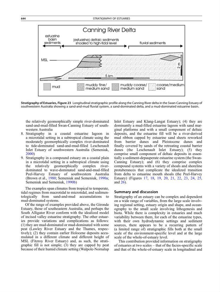
comprise small component of deltaic deposits in essentially a sediment-depauperate estuarine system (the SwanCanning Estuary); and (6) they comprise complex
compound systems with a variety of shoals and shoreline
protuberances that complicate the idealized transition
from delta to estuarine mouth shoals (the Peel-Harvey
Estuary) (Figures 17, 18, 19, 20, 21, 22, 23, 24, 25,
and 26).
Summary and discussion
Stratigraphy of an estuary can be complex and dependent
on a wide range of variables, from the large scale involving regional setting, estuary origin and shape, and oceanography to the small scale involving lithogenesis and
biota. While there is complexity in estuaries and much
variability between them, for each of the estuarine types,
with their own hydrodynamic settings and sediment
sources, there appears to be a recurring pattern of
(a limited range of) stratigraphic fills both at the small
scale of the environment-specific level and at the large
scale of the whole-of-estuary level.
This contribution provided information on stratigraphy
of estuaries at two scales – that of the facies-specific scale
and that of the whole-of-estuary scale in longitudinal and
Stratigraphy of Estuaries, Figure 23 Longitudinal stratigraphic profile along the Canning River delta in the Swan-Canning Estuary of
southwestern Australia showing a sand-and-mud fluvial system, a sand-dominated delta, and a mud-dominated estuarine basin.
644
STRATIGRAPHY OF ESTUARIES