

freshwater seepage from uplands bordering the estuarine
shore, the biodiversity and productivity of plant and animal biota, and the processes and products of evaporation.
Biogeography and animal productivity can determine the
extent that biostromes and reefs are developed as stratigraphic units. Plant productivity can determine the extent
that peat in high-tidal and supratidal areas and seagrasstrapped sand sheets in tidal and shallow subtidal areas
are developed as stratigraphic units. A selection of examples of the variability of large-scale whole-of-estuary stratigraphy from a range of case studies is provided below.
The examples for the large-scale whole-of-estuary stratigraphy are as follows (the shape and size of most of these
estuaries are shown in Figure 1):
1. Valley-fill stratigraphy in macrotidal settings in
a tropical climate using the relatively geomorphically
simple but sedimentologically complex tidedominated sand-and-mud-filled Fitzroy River Estuary
(King Sound) and the relatively geomorphically and
sedimentologically simple tide-dominated mud-filled
Lawley River Estuary of northwestern Australia
(Semeniuk, 1980, 1981, 1983, 1985a; Semeniuk and
Brocx, 2011; Figures 14 and 15)
2. Valley-fill and gulf-fill stratigraphy in a macrotidal
setting in a tropical climate using the relatively
geomorphically simple tide-dominated sand-andmud-filled Klang-Langat Estuary in Malaysia
(Coleman et al., 1970; Figure 16)
3. Valley-fill stratigraphy in a macrotidal setting in a temperate climate using the relatively geomorphically simple tide-dominated estuary of sand-and-mud-filled
Gironde and the tide-dominated sand-and-mud-filled
Thames estuary (Allen and Posamentier, 1993; Morgan, 2006; Khan et al., 2011)
4. Valley-fill stratigraphy in a microtidal to mesotidal setting in a temperate climate using the moderately
geomorphically complex mixed wave and tidedominated sand-and-mud-filled estuaries of southeastern Australia (Roy et al., 1980; Roy, 1984)
5. Stratigraphy in a meandering valley, on an alluvial
plain in a macrotidal setting in a tropical climate using
the relatively geomorphically complex tide-dominated
sand-and-mud-filled South Alligator River Estuary of
northern Australia (Woodroffe et al., 1985, 1986)
6. Valley-fill stratigraphy in a microtidal setting in a
temperate climate along a wave-dominated coast using
the relatively geomorphically complex intra-estuarine
wave-dominated
sand-and-mud-filled
WalpoleNornalup Inlet Estuary (Semeniuk et al., 2011)
7. Stratigraphy in a meandering valley on a coastal plain
in a microtidal setting in a temperate climate using
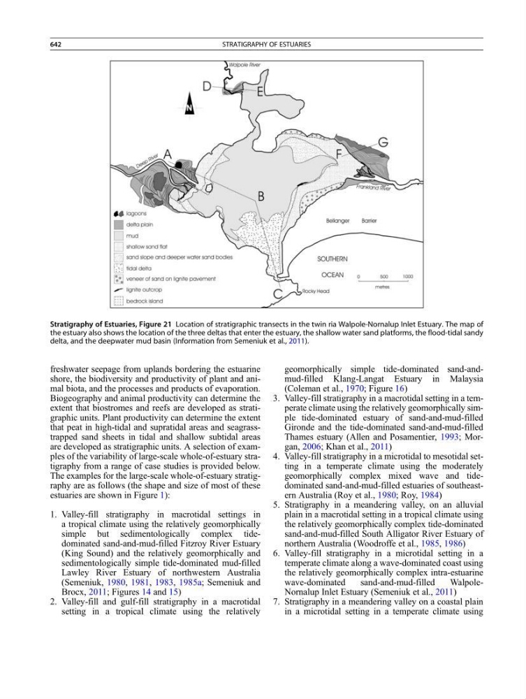
Stratigraphy of Estuaries, Figure 21 Location of stratigraphic transects in the twin ria Walpole-Nornalup Inlet Estuary. The map of
the estuary also shows the location of the three deltas that enter the estuary, the shallow water sand platforms, the flood-tidal sandy
delta, and the deepwater mud basin (Information from Semeniuk et al., 2011).
642
STRATIGRAPHY OF ESTUARIES