

SEDIMENT EROSION
Ayman A. Elgamal
Marine Geology Department, Coastal Research Institute,
National Water Research Center, Alexandria, Egypt
Definition
Sediment erosion is the process of detachment and transport of sediments by water, wind, ice, and gravity
(Kumar and Ramachandra, 2003).
Description
Estuarine erosion takes place by the wearing away of
shoreline and bottom sediments (Rogers and Skrabal,
2011). On an estuarine beach, sediment erosion occurs primarily by wave action, tidal currents, littoral currents, and
deflation (CERC, 1984).
Erosion is a natural geological process, and the rate of
shoreline and bottom sediment erosion will vary from
place to place (Rogers and Skrabal, 2011). It can be significantly modified by human activities (Striebig, 1999). The
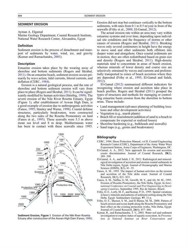
severe erosion of the Nile River Rosetta Estuary, Egypt
(Figure 1), after establishment of Aswan High Dam, is
a good example of erosion due to anthropogenic activities
(Fanos, 1995; Stanley and Warne, 1998). Coastal defense
structures, particularly breakwaters, were constructed
along the two sides of the Rosetta Promontory on land
(Fanos et al., 1995). These seawalls were 5.3 m above
mean sea level and 8 m deep. Mediterranean water
has been in contact with these seawalls since 1995.
Erosion did not stop but continues vertically to the bottom
sediments, with rates from 0.1 to 0.5 m/year in front of the
seawalls (Frihy et al., 2008; El-Gamal, 2012).
The actual erosion rate within an area may vary within
estuarine systems and over time, depending upon individual site conditions and the frequency of storms or other
causes of erosion (Rogers and Skrabal, 2011). Breaking
waves only several centimeters in height have the energy
to move sand and other sediments both offshore into
deeper water and alongshore. Once coastal sediments are
in motion, they are often redistributed based on grain size
and density (Rogers and Skrabal, 2011). High-density
materials tend to concentrate in areas of beach erosion,
whereas minerals of lower density and coarse size are
selectively entrained by waves and currents and preferentially transported to zones of beach accretion where they
are deposited (Frihy et al., 1995; El-Gamal and Saleh,
2012).
El-Gamal (2012) summarized different indicators for
recognizing where erosion and accretion take place in
beach profiles. Rogers and Skrabal (2011) grouped the
types of structures and methods for managing or controlling estuarine basin erosion from the shoreline to bottom
areas. These include:
• Land management (advance planning of building locations and other development activities)
• Vegetation (e.g., marsh plants)
• Beach fill or nourishment (addition of sand to a beach to
compensate for expected or realized losses)
• Shoreline hardening (e.g., bulkheads and seawalls)
• Sand traps (e.g., groins and breakwaters)
Bibliography
CERC, 1984. Shore Protection Manual, vol II. Coastal Engineering
Research Center (CERC), Department of the Army Water Ways
Experiment Station, Army Corps of Engineers, Washington, DC.
El-Gamal, A. A., 2012. New approach for erosion and accretion
coasts discrimination. Journal of Coastal Research, 28(2),
389–398.
El-Gamal, A. A., and Saleh, I. H., 2012. Radiological and mineralogical investigation of accretion and erosion coastal sediments in
Nile Delta region, Egypt. Journal of Oceanography and Marine
Science (JOMS), 3(3), 41–55.
Fanos, A. M., 1995. The impact of human activities on the erosion
and accretion of the Nile delta coast. Journal of Coastal
Research, 11(3), 821–833.
Fanos, A. M., Naffaa, G. M., Gewilli, M. Y., and Ali, M. M., 1995.
Erosion of Rosetta Promontory, the Nile Delta, Egypt. In International Conference on Coastal and Port Engineering in Developing Countries, September 1995, Rio de Janeiro, Brazil.
Frihy, O. E., Lotfy, M. F., and Komar, P. D., 1995. Spatial variations
in heavy minerals and patterns of sediment sorting along the Nile
Delta. Egypt. Sedimentary Geology, 97, 33 p.
Frihy, O. E., Shereet, S. M., and El Banna, M. M., 2008. Pattern of
beach erosion and scour depth along the Rosetta Promontory and
their effect on the existing protection works, Nile Delta, Egypt.
Journal of Coastal Research, 24(4), 857–866.
Kumar, R., and Ramachandra, T. V., 2003. Water soil and sediment
investigation to explore status of aquatic ecosystem. In Presentation at National Seminar on River Conservation and
1900
1941
1971
1982
1988
1990
1995
Protection line
0.0 1000 2000 3000 m
2005
2005
1995
1988
1982
Protection line
Existing
1971
1941
1900
Old
1964
1964
Sediment Erosion, Figure 1 Erosion of the Nile River Rosetta
Estuary after construction of the Aswan High Dam (Fanos, 1995).
554
SEDIMENT EROSION