

washovers, and tidal inlet and/or flood tidal deltas. The
inner fluvial zone is generally covered by a bayhead delta.
Tide-dominated estuaries show a slightly more complex
pattern, as the energy minimum is less pronounced. The
outer areas are dominated by elongate tidal sandbars,
evolving landward to sand flats. The central part is
characterized by a channel that shows a typical “straightmeandering-straight” pattern, where the meandering channel is equivalent to the low-energy central basin
(Figure 2). Apart from the two basic types, there are other
types of estuaries exhibiting strong physiographic control,
such as estuaries generated by tectonic processes (also
known as rias); rocky-coast estuaries, which show an
irregular basement morphology (Chaumillon et al.,
2010); and fjords, which are drowned glacial valleys
(Reineck and Singh, 1980).
Stratigraphic organization
Sediments underlying present-day estuaries usually accumulate over an incised valley which is laterally related to
a subaerial exposure erosional unconformity generated
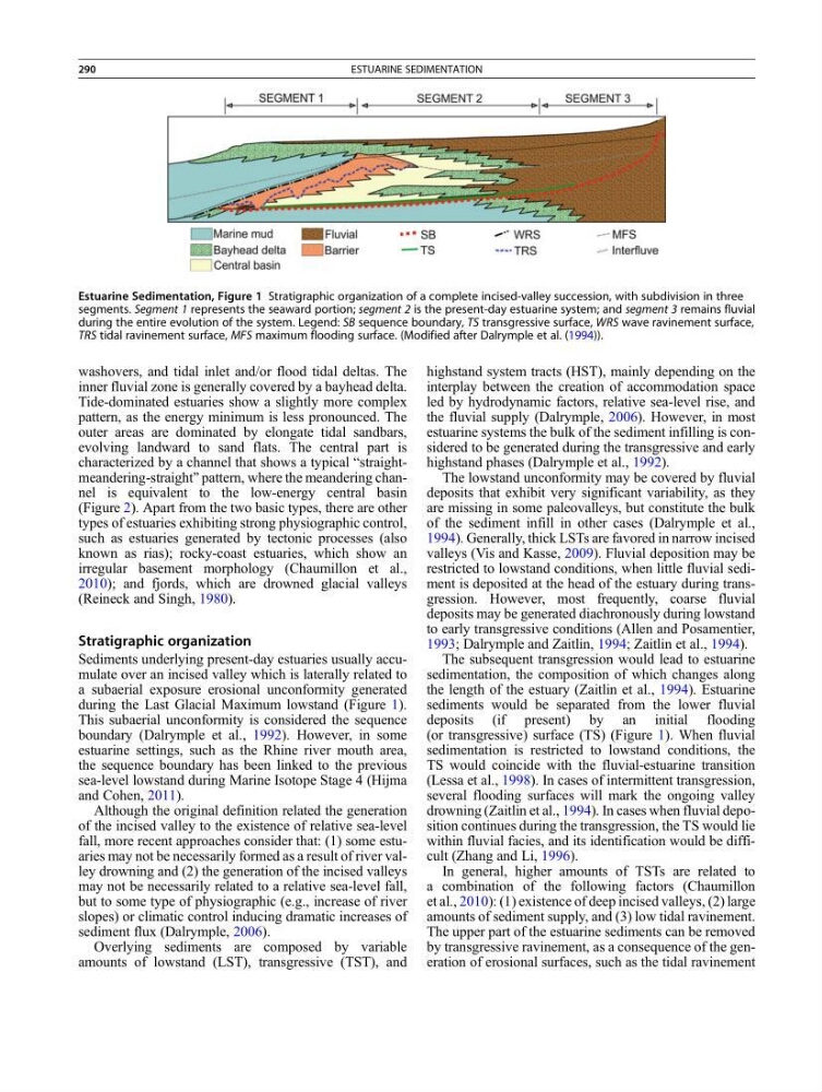
during the Last Glacial Maximum lowstand (Figure 1).
This subaerial unconformity is considered the sequence
boundary (Dalrymple et al., 1992). However, in some
estuarine settings, such as the Rhine river mouth area,
the sequence boundary has been linked to the previous
sea-level lowstand during Marine Isotope Stage 4 (Hijma
and Cohen, 2011).
Although the original definition related the generation
of the incised valley to the existence of relative sea-level
fall, more recent approaches consider that: (1) some estuaries may not be necessarily formed as a result of river valley drowning and (2) the generation of the incised valleys
may not be necessarily related to a relative sea-level fall,
but to some type of physiographic (e.g., increase of river
slopes) or climatic control inducing dramatic increases of
sediment flux (Dalrymple, 2006).
Overlying sediments are composed by variable
amounts of lowstand (LST), transgressive (TST), and
highstand system tracts (HST), mainly depending on the
interplay between the creation of accommodation space
led by hydrodynamic factors, relative sea-level rise, and
the fluvial supply (Dalrymple, 2006). However, in most
estuarine systems the bulk of the sediment infilling is considered to be generated during the transgressive and early
highstand phases (Dalrymple et al., 1992).
The lowstand unconformity may be covered by fluvial
deposits that exhibit very significant variability, as they
are missing in some paleovalleys, but constitute the bulk
of the sediment infill in other cases (Dalrymple et al.,
1994). Generally, thick LSTs are favored in narrow incised
valleys (Vis and Kasse, 2009). Fluvial deposition may be
restricted to lowstand conditions, when little fluvial sediment is deposited at the head of the estuary during transgression. However, most frequently, coarse fluvial
deposits may be generated diachronously during lowstand
to early transgressive conditions (Allen and Posamentier,
1993; Dalrymple and Zaitlin, 1994; Zaitlin et al., 1994).
The subsequent transgression would lead to estuarine
sedimentation, the composition of which changes along
the length of the estuary (Zaitlin et al., 1994). Estuarine
sediments would be separated from the lower fluvial
deposits (if present) by an initial flooding
(or transgressive) surface (TS) (Figure 1). When fluvial
sedimentation is restricted to lowstand conditions, the
TS would coincide with the fluvial-estuarine transition
(Lessa et al., 1998). In cases of intermittent transgression,
several flooding surfaces will mark the ongoing valley
drowning (Zaitlin et al., 1994). In cases when fluvial deposition continues during the transgression, the TS would lie
within fluvial facies, and its identification would be difficult (Zhang and Li, 1996).
In general, higher amounts of TSTs are related to
a combination of the following factors (Chaumillon
et al., 2010): (1) existence of deep incised valleys, (2) large
amounts of sediment supply, and (3) low tidal ravinement.
The upper part of the estuarine sediments can be removed
by transgressive ravinement, as a consequence of the generation of erosional surfaces, such as the tidal ravinement
Estuarine Sedimentation, Figure 1 Stratigraphic organization of a complete incised-valley succession, with subdivision in three
segments. Segment 1 represents the seaward portion; segment 2 is the present-day estuarine system; and segment 3 remains fluvial
during the entire evolution of the system. Legend: SB sequence boundary, TS transgressive surface, WRS wave ravinement surface,
TRS tidal ravinement surface, MFS maximum flooding surface. (Modified after Dalrymple et al. (1994)).
290
ESTUARINE SEDIMENTATION
inner fluvial zone is generally covered by a bayhead delta.
Tide-dominated estuaries show a slightly more complex
pattern, as the energy minimum is less pronounced. The
outer areas are dominated by elongate tidal sandbars,
evolving landward to sand flats. The central part is
characterized by a channel that shows a typical “straightmeandering-straight” pattern, where the meandering channel is equivalent to the low-energy central basin
(Figure 2). Apart from the two basic types, there are other
types of estuaries exhibiting strong physiographic control,
such as estuaries generated by tectonic processes (also
known as rias); rocky-coast estuaries, which show an
irregular basement morphology (Chaumillon et al.,
2010); and fjords, which are drowned glacial valleys
(Reineck and Singh, 1980).
Stratigraphic organization
Sediments underlying present-day estuaries usually accumulate over an incised valley which is laterally related to
a subaerial exposure erosional unconformity generated
during the Last Glacial Maximum lowstand (Figure 1).
This subaerial unconformity is considered the sequence
boundary (Dalrymple et al., 1992). However, in some
estuarine settings, such as the Rhine river mouth area,
the sequence boundary has been linked to the previous
sea-level lowstand during Marine Isotope Stage 4 (Hijma
and Cohen, 2011).
Although the original definition related the generation
of the incised valley to the existence of relative sea-level
fall, more recent approaches consider that: (1) some estuaries may not be necessarily formed as a result of river valley drowning and (2) the generation of the incised valleys
may not be necessarily related to a relative sea-level fall,
but to some type of physiographic (e.g., increase of river
slopes) or climatic control inducing dramatic increases of
sediment flux (Dalrymple, 2006).
Overlying sediments are composed by variable
amounts of lowstand (LST), transgressive (TST), and
highstand system tracts (HST), mainly depending on the
interplay between the creation of accommodation space
led by hydrodynamic factors, relative sea-level rise, and
the fluvial supply (Dalrymple, 2006). However, in most
estuarine systems the bulk of the sediment infilling is considered to be generated during the transgressive and early
highstand phases (Dalrymple et al., 1992).
The lowstand unconformity may be covered by fluvial
deposits that exhibit very significant variability, as they
are missing in some paleovalleys, but constitute the bulk
of the sediment infill in other cases (Dalrymple et al.,
1994). Generally, thick LSTs are favored in narrow incised
valleys (Vis and Kasse, 2009). Fluvial deposition may be
restricted to lowstand conditions, when little fluvial sediment is deposited at the head of the estuary during transgression. However, most frequently, coarse fluvial
deposits may be generated diachronously during lowstand
to early transgressive conditions (Allen and Posamentier,
1993; Dalrymple and Zaitlin, 1994; Zaitlin et al., 1994).
The subsequent transgression would lead to estuarine
sedimentation, the composition of which changes along
the length of the estuary (Zaitlin et al., 1994). Estuarine
sediments would be separated from the lower fluvial
deposits (if present) by an initial flooding
(or transgressive) surface (TS) (Figure 1). When fluvial
sedimentation is restricted to lowstand conditions, the
TS would coincide with the fluvial-estuarine transition
(Lessa et al., 1998). In cases of intermittent transgression,
several flooding surfaces will mark the ongoing valley
drowning (Zaitlin et al., 1994). In cases when fluvial deposition continues during the transgression, the TS would lie
within fluvial facies, and its identification would be difficult (Zhang and Li, 1996).
In general, higher amounts of TSTs are related to
a combination of the following factors (Chaumillon
et al., 2010): (1) existence of deep incised valleys, (2) large
amounts of sediment supply, and (3) low tidal ravinement.
The upper part of the estuarine sediments can be removed
by transgressive ravinement, as a consequence of the generation of erosional surfaces, such as the tidal ravinement
Estuarine Sedimentation, Figure 1 Stratigraphic organization of a complete incised-valley succession, with subdivision in three
segments. Segment 1 represents the seaward portion; segment 2 is the present-day estuarine system; and segment 3 remains fluvial
during the entire evolution of the system. Legend: SB sequence boundary, TS transgressive surface, WRS wave ravinement surface,
TRS tidal ravinement surface, MFS maximum flooding surface. (Modified after Dalrymple et al. (1994)).
290
ESTUARINE SEDIMENTATION