

A recurring suite of wet landforms on deltas are the
tidally wetted tidal flats, tidal creeks, and tidal shoals
and the subaerial parts of deltas wet by rain, floodwater,
and groundwater such as floodplains, local cheniers,
distributary channels, levee banks, water-filled and
sediment-filled abandoned channels, swales, and lagoons.
The terrain of a delta is essentially a nearly flat, low-lying
surface close to a water table, and, as such, the majority of
landforms within the delta are “wetlands,” but rather than
viewing the delta as a single wetland, the delta actually is
an integrated wetland complex composed of a mosaic of
different wetland types. Each may have been developed
by different sedimentologic/geomorphic processes, and
each may be maintained by one or more of the hydrologic
mechanisms operating on the delta. The hydrology and
hydrochemistry of a delta system generally is complex,
particularly for large deltas where there may be a large
number of landforms and stratigraphic units, a range of
water sources of different hydrochemistry, and a range
of hydrologic recharge mechanisms. Dependent on
whether the wetting of the terrain is by freshwater (rain
or river water), estuarine water, or marine water and on
how frequent is the wetting process, the groundwater
and/or surface water of the wetland may be freshwater,
brackish, or saline, and it may be stasohaline or
poikilohaline.
As such, a large range of wetlands can be developed
on a delta within an estuary, and there are a large
range of possible habitats for biota, determined by landforms, substrates, hydrology, hydroperiod, and salinity/
hydrochemistry.
The subaerial wetlands are classified according
to their geomorphic and hydrologic characteristics
(using the “geomorphic-hydrologic classification”) and
geomorphically for tidal wetlands. The “geomorphichydrologic classification,” recognizes that deltaic
wetlands are mainly basins, flats, and channels, and the
hydrological regimes that maintain them are permanent
inundation, seasonal inundation, seasonal waterlogging,
and intermittent inundation. For the tidally inundated part
of the deltas, the wetlands are identified as to geomorphic
units, viz., tidal flats, tidal creeks, and spits and cheniers.
Wetlands on deltas, depending on their origin, height
relative to a water table, and location relative to the river
source or marine outlet, have specific characteristics
stratigraphically, pedogenically, hydrologically, and
hydrochemically. As such, they may function as different
habitats for biota. A wide range of biota inhabits deltaic
estuarine wetlands developed on terrestrial wetland types
and marine/estuarine wetland types and determined by
substrates, salinity and hydrochemistry, hydroperiod,
height of the wetland above MSL, and tidal range.
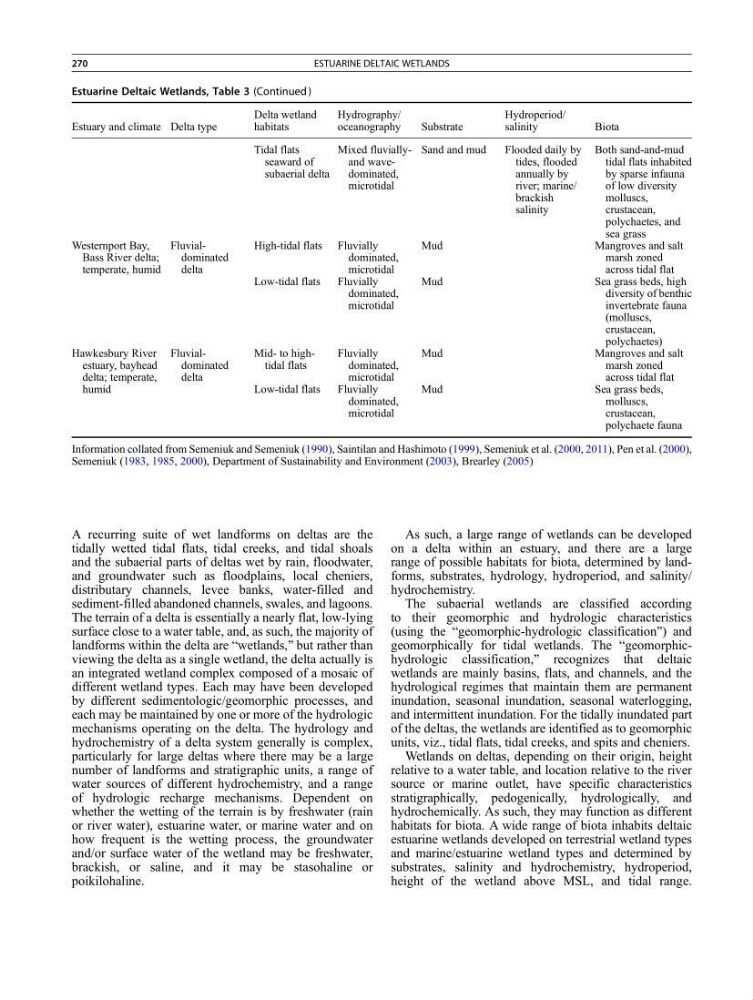
Estuarine Deltaic Wetlands, Table 3 (Continued )
Estuary and climate Delta type
Delta wetland
habitats
Hydrography/
oceanography
Substrate
Hydroperiod/
salinity
Biota
Tidal flats
seaward of
subaerial delta
Mixed fluviallyand wavedominated,
microtidal
Sand and mud
Flooded daily by
tides, flooded
annually by
river; marine/
brackish
salinity
Both sand-and-mud
tidal flats inhabited
by sparse infauna
of low diversity
molluscs,
crustacean,
polychaetes, and
sea grass
Westernport Bay,
Bass River delta;
temperate, humid
Fluvialdominated
delta
High-tidal flats Fluvially
dominated,
microtidal
Mud
Mangroves and salt
marsh zoned
across tidal flat
Low-tidal flats
Fluvially
dominated,
microtidal
Mud
Sea grass beds, high
diversity of benthic
invertebrate fauna
(molluscs,
crustacean,
polychaetes)
Hawkesbury River
estuary, bayhead
delta; temperate,
humid
Fluvialdominated
delta
Mid- to hightidal flats
Fluvially
dominated,
microtidal
Mud
Mangroves and salt
marsh zoned
across tidal flat
Low-tidal flats
Fluvially
dominated,
microtidal
Mud
Sea grass beds,
molluscs,
crustacean,
polychaete fauna
Information collated from Semeniuk and Semeniuk (1990), Saintilan and Hashimoto (1999), Semeniuk et al. (2000, 2011), Pen et al. (2000),
Semeniuk (1983, 1985, 2000), Department of Sustainability and Environment (2003), Brearley (2005)
270
ESTUARINE DELTAIC WETLANDS
tidally wetted tidal flats, tidal creeks, and tidal shoals
and the subaerial parts of deltas wet by rain, floodwater,
and groundwater such as floodplains, local cheniers,
distributary channels, levee banks, water-filled and
sediment-filled abandoned channels, swales, and lagoons.
The terrain of a delta is essentially a nearly flat, low-lying
surface close to a water table, and, as such, the majority of
landforms within the delta are “wetlands,” but rather than
viewing the delta as a single wetland, the delta actually is
an integrated wetland complex composed of a mosaic of
different wetland types. Each may have been developed
by different sedimentologic/geomorphic processes, and
each may be maintained by one or more of the hydrologic
mechanisms operating on the delta. The hydrology and
hydrochemistry of a delta system generally is complex,
particularly for large deltas where there may be a large
number of landforms and stratigraphic units, a range of
water sources of different hydrochemistry, and a range
of hydrologic recharge mechanisms. Dependent on
whether the wetting of the terrain is by freshwater (rain
or river water), estuarine water, or marine water and on
how frequent is the wetting process, the groundwater
and/or surface water of the wetland may be freshwater,
brackish, or saline, and it may be stasohaline or
poikilohaline.
As such, a large range of wetlands can be developed
on a delta within an estuary, and there are a large
range of possible habitats for biota, determined by landforms, substrates, hydrology, hydroperiod, and salinity/
hydrochemistry.
The subaerial wetlands are classified according
to their geomorphic and hydrologic characteristics
(using the “geomorphic-hydrologic classification”) and
geomorphically for tidal wetlands. The “geomorphichydrologic classification,” recognizes that deltaic
wetlands are mainly basins, flats, and channels, and the
hydrological regimes that maintain them are permanent
inundation, seasonal inundation, seasonal waterlogging,
and intermittent inundation. For the tidally inundated part
of the deltas, the wetlands are identified as to geomorphic
units, viz., tidal flats, tidal creeks, and spits and cheniers.
Wetlands on deltas, depending on their origin, height
relative to a water table, and location relative to the river
source or marine outlet, have specific characteristics
stratigraphically, pedogenically, hydrologically, and
hydrochemically. As such, they may function as different
habitats for biota. A wide range of biota inhabits deltaic
estuarine wetlands developed on terrestrial wetland types
and marine/estuarine wetland types and determined by
substrates, salinity and hydrochemistry, hydroperiod,
height of the wetland above MSL, and tidal range.
Estuarine Deltaic Wetlands, Table 3 (Continued )
Estuary and climate Delta type
Delta wetland
habitats
Hydrography/
oceanography
Substrate
Hydroperiod/
salinity
Biota
Tidal flats
seaward of
subaerial delta
Mixed fluviallyand wavedominated,
microtidal
Sand and mud
Flooded daily by
tides, flooded
annually by
river; marine/
brackish
salinity
Both sand-and-mud
tidal flats inhabited
by sparse infauna
of low diversity
molluscs,
crustacean,
polychaetes, and
sea grass
Westernport Bay,
Bass River delta;
temperate, humid
Fluvialdominated
delta
High-tidal flats Fluvially
dominated,
microtidal
Mud
Mangroves and salt
marsh zoned
across tidal flat
Low-tidal flats
Fluvially
dominated,
microtidal
Mud
Sea grass beds, high
diversity of benthic
invertebrate fauna
(molluscs,
crustacean,
polychaetes)
Hawkesbury River
estuary, bayhead
delta; temperate,
humid
Fluvialdominated
delta
Mid- to hightidal flats
Fluvially
dominated,
microtidal
Mud
Mangroves and salt
marsh zoned
across tidal flat
Low-tidal flats
Fluvially
dominated,
microtidal
Mud
Sea grass beds,
molluscs,
crustacean,
polychaete fauna
Information collated from Semeniuk and Semeniuk (1990), Saintilan and Hashimoto (1999), Semeniuk et al. (2000, 2011), Pen et al. (2000),
Semeniuk (1983, 1985, 2000), Department of Sustainability and Environment (2003), Brearley (2005)
270
ESTUARINE DELTAIC WETLANDS