

as earthquakes and tsunami, can alter habitat such that,
on a local scale, coastal habitats become changed. The
effects of earthquakes and tsunami, and the associated
natural changes in biology, depend on several major factors, including the degree of land and bed elevation
changes, relations to recruitment seasons, the life history
characteristics of species, and the degree of interaction
with human-altered environments which can act as a
source of contamination and debris and provide fixed
boundaries that limit subsequent, post-quake coastal and
estuarine adjustments.
Geological and geomorphic effects
Two of the most apparent and immediate effects of earthquakes on estuary geomorphology concern the disturbance
of bed sediments and levels, with immediate flow on effects
on tidal inundation patterns and longer-term effects on
estuary hydrology, shoreline stability, and ecological zones.
The saturated, soft sediments of estuaries are prone to liquefaction during shaking produced in earthquakes, expressed
as the surface rupture of sand volcanoes, as well as sediment
compaction and subsidence. Bed levels are also affected by
underlying bedrock deformation, although the surface
expression of uplifted bedrock may be dampened by the
compaction of overlying sediments. During the February
2011 Christchurch, New Zealand, M w 6.3 earthquake, up
to 0.5 m uplift and subsidence were produced in the southern two thirds and northern third of the Avon-Heathcote
Estuary/Ihutai, respectively, reducing the overall tidal prism
by 14 % or one million liters and the mid-tide wetted area by
18 % (Measures et al., 2011). These changes occurred due
to both soft sediment settling and bedrock deformation,
with subsequent changes in the estuary’s entrance channel
and shoreline expected in the future as the hydraulics adjust
to the altered bed. Over 40 % of the surface of this estuary’s
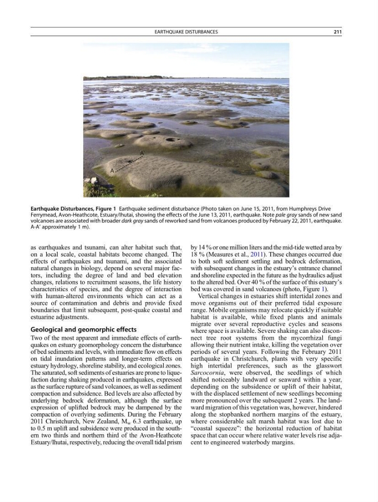
bed was covered in sand volcanoes (photo, Figure 1).
Vertical changes in estuaries shift intertidal zones and
move organisms out of their preferred tidal exposure
range. Mobile organisms may relocate quickly if suitable
habitat is available, while fixed plants and animals
migrate over several reproductive cycles and seasons
where space is available. Severe shaking can also disconnect tree root systems from the mycorrhizal fungi
allowing their nutrient intake, killing the vegetation over
periods of several years. Following the February 2011
earthquake in Christchurch, plants with very specific
high intertidal preferences, such as the glasswort
Sarcocornia, were observed, the seedlings of which
shifted noticeably landward or seaward within a year,
depending on the subsidence or uplift of their habitat,
with the displaced settlement of new seedlings becoming
more pronounced over the subsequent 2 years. The landward migration of this vegetation was, however, hindered
along the stopbanked northern margins of the estuary,
where considerable salt marsh habitat was lost due to
“coastal squeeze”: the horizontal reduction of habitat
space that can occur where relative water levels rise adjacent to engineered waterbody margins.
Earthquake Disturbances, Figure 1 Earthquake sediment disturbance (Photo taken on June 15, 2011, from Humphreys Drive
Ferrymead, Avon-Heathcote, Estuary/Ihutai, showing the effects of the June 13, 2011, earthquake. Note pale gray sands of new sand
volcanoes are associated with broader dark gray sands of reworked sand from volcanoes produced by February 22, 2011, earthquake.
A-A’ approximately 1 m).
EARTHQUAKE DISTURBANCES
211
on a local scale, coastal habitats become changed. The
effects of earthquakes and tsunami, and the associated
natural changes in biology, depend on several major factors, including the degree of land and bed elevation
changes, relations to recruitment seasons, the life history
characteristics of species, and the degree of interaction
with human-altered environments which can act as a
source of contamination and debris and provide fixed
boundaries that limit subsequent, post-quake coastal and
estuarine adjustments.
Geological and geomorphic effects
Two of the most apparent and immediate effects of earthquakes on estuary geomorphology concern the disturbance
of bed sediments and levels, with immediate flow on effects
on tidal inundation patterns and longer-term effects on
estuary hydrology, shoreline stability, and ecological zones.
The saturated, soft sediments of estuaries are prone to liquefaction during shaking produced in earthquakes, expressed
as the surface rupture of sand volcanoes, as well as sediment
compaction and subsidence. Bed levels are also affected by
underlying bedrock deformation, although the surface
expression of uplifted bedrock may be dampened by the
compaction of overlying sediments. During the February
2011 Christchurch, New Zealand, M w 6.3 earthquake, up
to 0.5 m uplift and subsidence were produced in the southern two thirds and northern third of the Avon-Heathcote
Estuary/Ihutai, respectively, reducing the overall tidal prism
by 14 % or one million liters and the mid-tide wetted area by
18 % (Measures et al., 2011). These changes occurred due
to both soft sediment settling and bedrock deformation,
with subsequent changes in the estuary’s entrance channel
and shoreline expected in the future as the hydraulics adjust
to the altered bed. Over 40 % of the surface of this estuary’s
bed was covered in sand volcanoes (photo, Figure 1).
Vertical changes in estuaries shift intertidal zones and
move organisms out of their preferred tidal exposure
range. Mobile organisms may relocate quickly if suitable
habitat is available, while fixed plants and animals
migrate over several reproductive cycles and seasons
where space is available. Severe shaking can also disconnect tree root systems from the mycorrhizal fungi
allowing their nutrient intake, killing the vegetation over
periods of several years. Following the February 2011
earthquake in Christchurch, plants with very specific
high intertidal preferences, such as the glasswort
Sarcocornia, were observed, the seedlings of which
shifted noticeably landward or seaward within a year,
depending on the subsidence or uplift of their habitat,
with the displaced settlement of new seedlings becoming
more pronounced over the subsequent 2 years. The landward migration of this vegetation was, however, hindered
along the stopbanked northern margins of the estuary,
where considerable salt marsh habitat was lost due to
“coastal squeeze”: the horizontal reduction of habitat
space that can occur where relative water levels rise adjacent to engineered waterbody margins.
Earthquake Disturbances, Figure 1 Earthquake sediment disturbance (Photo taken on June 15, 2011, from Humphreys Drive
Ferrymead, Avon-Heathcote, Estuary/Ihutai, showing the effects of the June 13, 2011, earthquake. Note pale gray sands of new sand
volcanoes are associated with broader dark gray sands of reworked sand from volcanoes produced by February 22, 2011, earthquake.
A-A’ approximately 1 m).
EARTHQUAKE DISTURBANCES
211