

sediment as it encounters stagnant waters. This process is
related to spring tides and ends before the following neap
tide (Augustinus, 1980; Augustinus et al., 1989).
Fine-sandy cheniers originate at the mean low water
level, where unsorted mudflat deposits are stirred up by
waves and currents. Sand settles on the more tranquil nearshore waters, while the finer sediment is transported farther, forming a longshore bar that moves obliquely
landward, gathering volume and height. When the
up-current end attaches to the mainland, it appears similar
to a spit, with a lagoon-like tidal flat behind it. The main
body of the fine-sandy cheniers is composed of a thick
bed set of gently seaward-dipping laminate with intercalated thin sets of coarser, steeply landward-dipping shelly
layers. The lagoon-like tidal flat is characterized by
interlayered sand/mud bedding (Augustinus, 1980;
Augustinus et al., 1989).
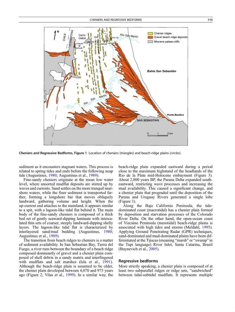
The transition from beach ridges to cheniers is a matter
of sediment availability. In San Sebastian Bay, Tierra del
Fuego, a river runs between the boundary of a beach ridge
composed dominantly of gravel and a chenier plain composed of shell debris in a sandy matrix and interfingered
with mudflats and salt marshes (Isla et al., 1991).
Although the beach-ridge plain is assumed to be older,
the chenier plain developed between 4,070 and 975 years
ago (Figure 2; Vilas et al., 1999). In a similar way, the
beach-ridge plain expanded eastward during a period
close to the maximum highstand of the headlands of the
Rio de la Plata mid-Holocene embayment (Figure 3).
About 2,800 years BP, the Parana Delta expanded southeastward, restricting wave processes and increasing the
mud availability. This caused a significant change, and
a chenier plain that prograded until the deposition of the
Parana and Uruguay Rivers generated a single lobe
(Figure 3).
Along the Baja California Peninsula, the tidedominated coast (macrotidal) has a chenier plain formed
by deposition and starvation processes of the Colorado
River Delta. On the other hand, the open-ocean coast
of Vizcaino Peninsula (mesotidal) beach-ridge plains is
associated with high tides and storms (Meldahl, 1995).
Applying Ground Penetrating Radar (GPR) techniques,
sand-dominated and mud-dominated plains have been differentiated at the Tijucas (meaning “marsh” or “swamp” in
the Tupi language) River Inlet, Santa Catarina, Brazil
(Buynevich et al., 2005).
Regressive bedforms
More strictly speaking, a chenier plain is composed of at
least two subparallel ridges or ridge sets, “sandwiched”
between tidal-subtidal mudflats. It represents multiple
Cheniers and Regressive Bedforms, Figure 1 Location of cheniers (triangles) and beach-ridge plains (circles).
CHENIERS AND REGRESSIVE BEDFORMS
115
related to spring tides and ends before the following neap
tide (Augustinus, 1980; Augustinus et al., 1989).
Fine-sandy cheniers originate at the mean low water
level, where unsorted mudflat deposits are stirred up by
waves and currents. Sand settles on the more tranquil nearshore waters, while the finer sediment is transported farther, forming a longshore bar that moves obliquely
landward, gathering volume and height. When the
up-current end attaches to the mainland, it appears similar
to a spit, with a lagoon-like tidal flat behind it. The main
body of the fine-sandy cheniers is composed of a thick
bed set of gently seaward-dipping laminate with intercalated thin sets of coarser, steeply landward-dipping shelly
layers. The lagoon-like tidal flat is characterized by
interlayered sand/mud bedding (Augustinus, 1980;
Augustinus et al., 1989).
The transition from beach ridges to cheniers is a matter
of sediment availability. In San Sebastian Bay, Tierra del
Fuego, a river runs between the boundary of a beach ridge
composed dominantly of gravel and a chenier plain composed of shell debris in a sandy matrix and interfingered
with mudflats and salt marshes (Isla et al., 1991).
Although the beach-ridge plain is assumed to be older,
the chenier plain developed between 4,070 and 975 years
ago (Figure 2; Vilas et al., 1999). In a similar way, the
beach-ridge plain expanded eastward during a period
close to the maximum highstand of the headlands of the
Rio de la Plata mid-Holocene embayment (Figure 3).
About 2,800 years BP, the Parana Delta expanded southeastward, restricting wave processes and increasing the
mud availability. This caused a significant change, and
a chenier plain that prograded until the deposition of the
Parana and Uruguay Rivers generated a single lobe
(Figure 3).
Along the Baja California Peninsula, the tidedominated coast (macrotidal) has a chenier plain formed
by deposition and starvation processes of the Colorado
River Delta. On the other hand, the open-ocean coast
of Vizcaino Peninsula (mesotidal) beach-ridge plains is
associated with high tides and storms (Meldahl, 1995).
Applying Ground Penetrating Radar (GPR) techniques,
sand-dominated and mud-dominated plains have been differentiated at the Tijucas (meaning “marsh” or “swamp” in
the Tupi language) River Inlet, Santa Catarina, Brazil
(Buynevich et al., 2005).
Regressive bedforms
More strictly speaking, a chenier plain is composed of at
least two subparallel ridges or ridge sets, “sandwiched”
between tidal-subtidal mudflats. It represents multiple
Cheniers and Regressive Bedforms, Figure 1 Location of cheniers (triangles) and beach-ridge plains (circles).
CHENIERS AND REGRESSIVE BEDFORMS
115