

67
mexicana (average 2%) represented secondary forms. Species number (average 11
species) was moderate. This interval with stabilized foraminiferal content characterizes the modern regenerated salt-marsh environment.
The sand pattern along this core clearly illustrates that as regeneration progressed
sandy (from 33% of sand in DI 2 to 35% in DI 1) tidal waters inundated the muddy
(8% of sand) agricultural lands of DI 3 (Table 2.3; Fig. 2.15).
2.6.2.2 Dating the Sedimentary Record
The Isuskiza core did not show a clear
210
Pb xs exponential decay profile discarding
any age determination (Fig. 2.16). The
137
Cs activity maximum at 18 cm was located
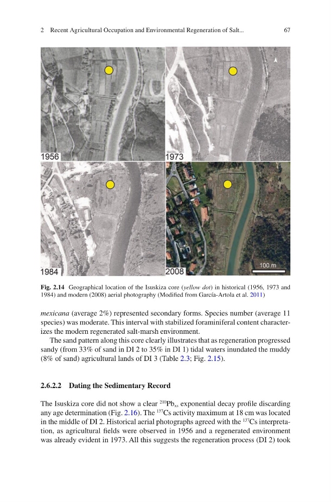
in the middle of DI 2. Historical aerial photographs agreed with the
137
Cs interpretation, as agricultural fields were observed in 1956 and a regenerated environment
was already evident in 1973. All this suggests the regeneration process (DI 2) took
Fig. 2.14 Geographical location of the Isuskiza core (yellow dot) in historical (1956, 1973 and
1984) and modern (2008) aerial photography (Modified from García-Artola et al. 2011)
2 Recent Agricultural Occupation and Environmental Regeneration of Salt...
mexicana (average 2%) represented secondary forms. Species number (average 11
species) was moderate. This interval with stabilized foraminiferal content characterizes the modern regenerated salt-marsh environment.
The sand pattern along this core clearly illustrates that as regeneration progressed
sandy (from 33% of sand in DI 2 to 35% in DI 1) tidal waters inundated the muddy
(8% of sand) agricultural lands of DI 3 (Table 2.3; Fig. 2.15).
2.6.2.2 Dating the Sedimentary Record
The Isuskiza core did not show a clear
210
Pb xs exponential decay profile discarding
any age determination (Fig. 2.16). The
137
Cs activity maximum at 18 cm was located
in the middle of DI 2. Historical aerial photographs agreed with the
137
Cs interpretation, as agricultural fields were observed in 1956 and a regenerated environment
was already evident in 1973. All this suggests the regeneration process (DI 2) took
Fig. 2.14 Geographical location of the Isuskiza core (yellow dot) in historical (1956, 1973 and
1984) and modern (2008) aerial photography (Modified from García-Artola et al. 2011)
2 Recent Agricultural Occupation and Environmental Regeneration of Salt...