

486
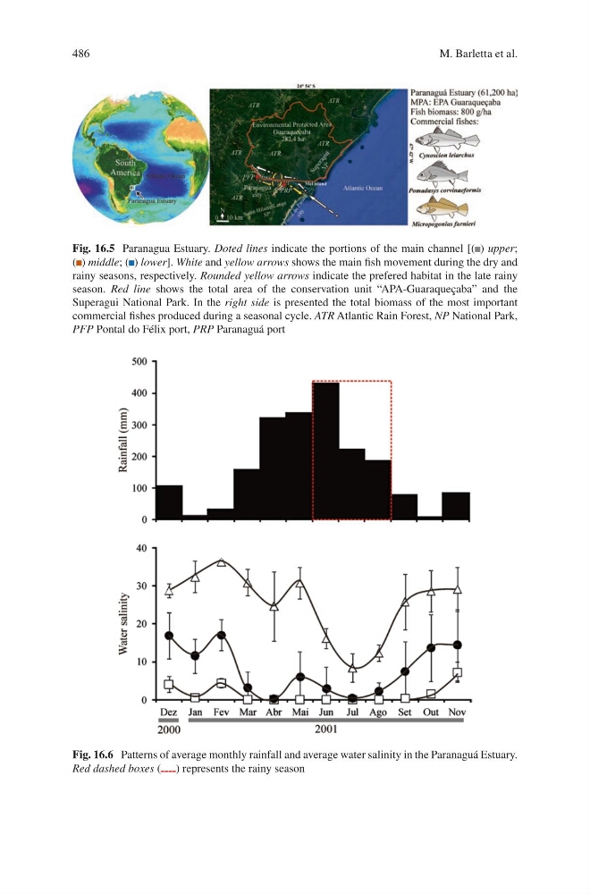
Fig. 16.5 Paranagua Estuary. Doted lines indicate the portions of the main channel [( ) upper;
( ) middle; ( ) lower]. White and yellow arrows shows the main fish movement during the dry and
rainy seasons, respectively. Rounded yellow arrows indicate the prefered habitat in the late rainy
season. Red line shows the total area of the conservation unit “APA-Guaraqueçaba” and the
Superagui National Park. In the right side is presented the total biomass of the most important
commercial fishes produced during a seasonal cycle. ATR Atlantic Rain Forest, NP National Park,
PFP Pontal do Félix port, PRP Paranaguá port
Fig. 16.6 Patterns of average monthly rainfall and average water salinity in the Paranaguá Estuary.
Red dashed boxes ( ) represents the rainy season
M. Barletta et al.
Fig. 16.5 Paranagua Estuary. Doted lines indicate the portions of the main channel [( ) upper;
( ) middle; ( ) lower]. White and yellow arrows shows the main fish movement during the dry and
rainy seasons, respectively. Rounded yellow arrows indicate the prefered habitat in the late rainy
season. Red line shows the total area of the conservation unit “APA-Guaraqueçaba” and the
Superagui National Park. In the right side is presented the total biomass of the most important
commercial fishes produced during a seasonal cycle. ATR Atlantic Rain Forest, NP National Park,
PFP Pontal do Félix port, PRP Paranaguá port
Fig. 16.6 Patterns of average monthly rainfall and average water salinity in the Paranaguá Estuary.
Red dashed boxes ( ) represents the rainy season
M. Barletta et al.