

172
The environmental and cultural features emphasize the unique character of the
Coastal Zone, urbanization, identifying it as a public space for recreation and, in
some cases, preservation. The urbanization process changes the space with allotments, vertical and horizontal condominiums for second homes near large urban
centers, hotel complexes and resorts for domestic and international tourism in different beautiful areas (Strohaeckeri 2008).
According to Strohaeckeri (2008), in the last two decades, the productive restructuring and modernization of port industrial complexes in the east and south coast
highlight the concern in adjusting the country to the demands of the global economic market. This suggests an overlap and interconnection of active processes in
the Brazilian Coastal Zone: industrialization, urbanization, tourist development and
real estate, productive restructuration, migration and, to a lesser extent, emancipations (Strohaeckeri 2008).
In the current Brazilian coastline, we can distinguish two main economical
macro sets (Strohaeckeri 2008):
(a) the first includes the South and East Coasts and part of the North Coast – from
Rio Grande do Sul to the metropolitan area of Fortaleza – and is mainly characterized by urban occupation and the revaluing of land use, including urban
interstitial spaces that have resulted from land reserves for commercial purposes or for economic activities such as forestry, rice cultivation, agriculture
and extensive livestock;
(b) the second covers the rest of the North Coast, from the metropolitan area of
Fortaleza, in Ceará, to Amapá, on the border with the French Guiana. It is
sparsely occupied, with low population density, large unoccupied areas and traditional extracting and collecting communities. Highlight to some regional centrality poles, like Parnaíba (PI) and Macapá (AP), and metropolitan
concentrations in Belém (PA) and São Luís (MA).
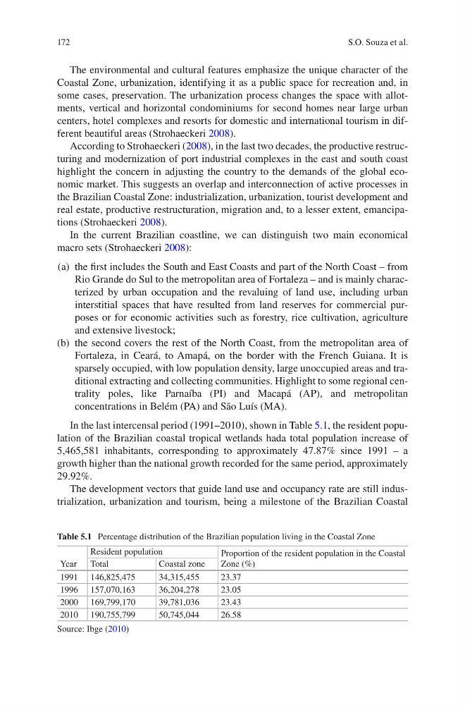
In the last intercensal period (1991–2010), shown in Table 5.1, the resident population of the Brazilian coastal tropical wetlands hada total population increase of
5,465,581 inhabitants, corresponding to approximately 47.87% since 1991 – a
growth higher than the national growth recorded for the same period, approximately
29.92%.
The development vectors that guide land use and occupancy rate are still industrialization, urbanization and tourism, being a milestone of the Brazilian Coastal
Table 5.1 Percentage distribution of the Brazilian population living in the Coastal Zone
Year
Resident population
Proportion of the resident population in the Coastal
Zone (%)
Total
Coastal zone
1991 146,825,475
34,315,455
23.37
1996 157,070,163
36,204,278
23.05
2000 169,799,170
39,781,036
23.43
2010 190,755,799
50,745,044
26.58
Source: Ibge (2010)
S.O. Souza et al.
The environmental and cultural features emphasize the unique character of the
Coastal Zone, urbanization, identifying it as a public space for recreation and, in
some cases, preservation. The urbanization process changes the space with allotments, vertical and horizontal condominiums for second homes near large urban
centers, hotel complexes and resorts for domestic and international tourism in different beautiful areas (Strohaeckeri 2008).
According to Strohaeckeri (2008), in the last two decades, the productive restructuring and modernization of port industrial complexes in the east and south coast
highlight the concern in adjusting the country to the demands of the global economic market. This suggests an overlap and interconnection of active processes in
the Brazilian Coastal Zone: industrialization, urbanization, tourist development and
real estate, productive restructuration, migration and, to a lesser extent, emancipations (Strohaeckeri 2008).
In the current Brazilian coastline, we can distinguish two main economical
macro sets (Strohaeckeri 2008):
(a) the first includes the South and East Coasts and part of the North Coast – from
Rio Grande do Sul to the metropolitan area of Fortaleza – and is mainly characterized by urban occupation and the revaluing of land use, including urban
interstitial spaces that have resulted from land reserves for commercial purposes or for economic activities such as forestry, rice cultivation, agriculture
and extensive livestock;
(b) the second covers the rest of the North Coast, from the metropolitan area of
Fortaleza, in Ceará, to Amapá, on the border with the French Guiana. It is
sparsely occupied, with low population density, large unoccupied areas and traditional extracting and collecting communities. Highlight to some regional centrality poles, like Parnaíba (PI) and Macapá (AP), and metropolitan
concentrations in Belém (PA) and São Luís (MA).
In the last intercensal period (1991–2010), shown in Table 5.1, the resident population of the Brazilian coastal tropical wetlands hada total population increase of
5,465,581 inhabitants, corresponding to approximately 47.87% since 1991 – a
growth higher than the national growth recorded for the same period, approximately
29.92%.
The development vectors that guide land use and occupancy rate are still industrialization, urbanization and tourism, being a milestone of the Brazilian Coastal
Table 5.1 Percentage distribution of the Brazilian population living in the Coastal Zone
Year
Resident population
Proportion of the resident population in the Coastal
Zone (%)
Total
Coastal zone
1991 146,825,475
34,315,455
23.37
1996 157,070,163
36,204,278
23.05
2000 169,799,170
39,781,036
23.43
2010 190,755,799
50,745,044
26.58
Source: Ibge (2010)
S.O. Souza et al.