

252
c. Kaml . S. Soyupak
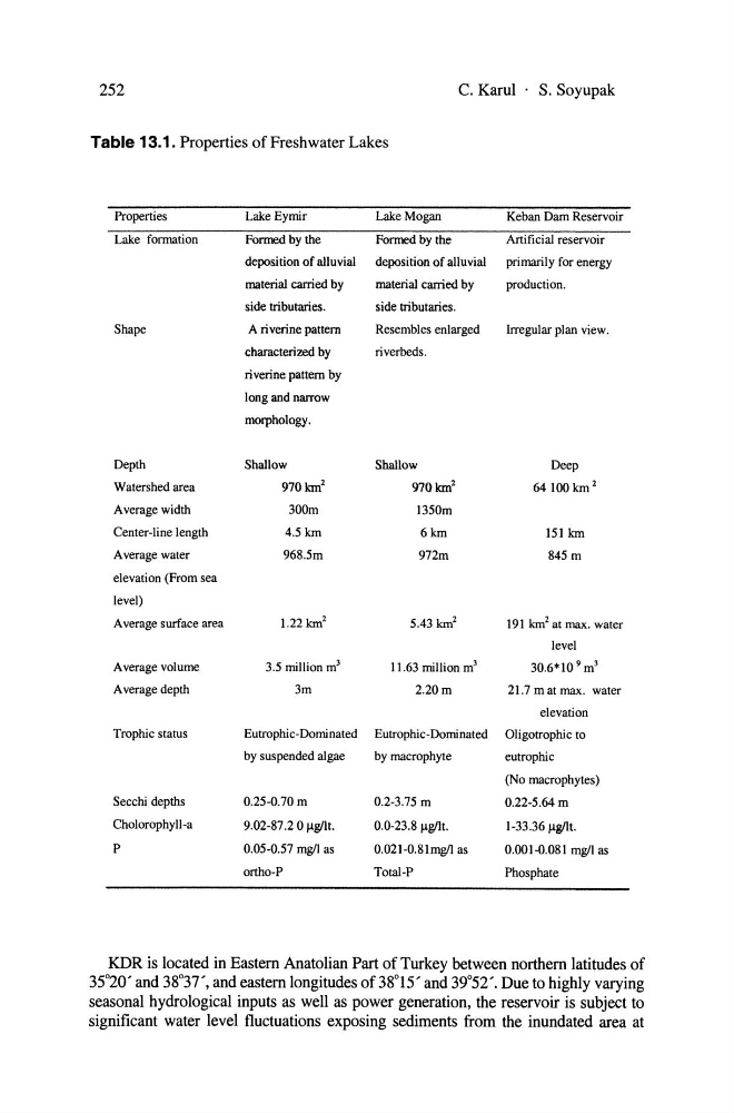
Table 13.1. Properties of Freshwater Lakes
Properties
Lake Eymir
Lake Mogan
Keban Dam Reservoir
Lake fonnation
Formed by the
Formed by the
Artificial reservoir
deposition of alluvial
deposition of alluvial
primarily for energy
material carried by
material canied by
production.
side tributaries.
side tributaries.
Shape
A ri verine pattern
Resembles enlarged
Irregular plan view.
characterized by
riverbeds.
ri verine pattern by
long and narrow
morphology.
Depth
Shallow
Shallow
Deep
Watershed area
970km 2
970km 2
64100km 2
Average width
300m
1350m
Center-line length
4.5 km
6km
151 km
Average water
968.5m
972m
845 m
elevation (From sea
level)
Average surfaee area
1.22 km 2
5.43 km 2
191 km 2 at max. water
level
Average volume
3.5 million m 3
11.63 million m 3
30.6*10 9 m 3
Average depth
3m
2.20m
21.7 m at max. water
elevation
Trophie status
Eutrophie-Dominated Eutrophie-Dominated Oligotrophie to
by suspended algae
by maerophyte
eutrophie
(No macrophytes)
Secchi depths
0.25-0.70 m
0.2-3.75 m
0.22-5.64m
Cholorophyll-a
9.02-87.2 0llg/lt.
0.0-23.8 Ilg/It.
1-33.36 1lg!It.
P
0.05-0.57 mg/I as
0.021-0.81mgll as
0.001-0.081 mg/I as
ortho-P
Total-P
Phosphate
KDR is located in Eastem Anatolian Part of Turkey between northem latitudes of
35°20' and 38°37', and eastem longitudes of 38°15' and 39°52'. Due to highly varying
seasonal hydrological inputs as weIl as power generation, the reservoir is subject to
significant water level fluctuations exposing sediments from the inundated area at
c. Kaml . S. Soyupak
Table 13.1. Properties of Freshwater Lakes
Properties
Lake Eymir
Lake Mogan
Keban Dam Reservoir
Lake fonnation
Formed by the
Formed by the
Artificial reservoir
deposition of alluvial
deposition of alluvial
primarily for energy
material carried by
material canied by
production.
side tributaries.
side tributaries.
Shape
A ri verine pattern
Resembles enlarged
Irregular plan view.
characterized by
riverbeds.
ri verine pattern by
long and narrow
morphology.
Depth
Shallow
Shallow
Deep
Watershed area
970km 2
970km 2
64100km 2
Average width
300m
1350m
Center-line length
4.5 km
6km
151 km
Average water
968.5m
972m
845 m
elevation (From sea
level)
Average surfaee area
1.22 km 2
5.43 km 2
191 km 2 at max. water
level
Average volume
3.5 million m 3
11.63 million m 3
30.6*10 9 m 3
Average depth
3m
2.20m
21.7 m at max. water
elevation
Trophie status
Eutrophie-Dominated Eutrophie-Dominated Oligotrophie to
by suspended algae
by maerophyte
eutrophie
(No macrophytes)
Secchi depths
0.25-0.70 m
0.2-3.75 m
0.22-5.64m
Cholorophyll-a
9.02-87.2 0llg/lt.
0.0-23.8 Ilg/It.
1-33.36 1lg!It.
P
0.05-0.57 mg/I as
0.021-0.81mgll as
0.001-0.081 mg/I as
ortho-P
Total-P
Phosphate
KDR is located in Eastem Anatolian Part of Turkey between northem latitudes of
35°20' and 38°37', and eastem longitudes of 38°15' and 39°52'. Due to highly varying
seasonal hydrological inputs as weIl as power generation, the reservoir is subject to
significant water level fluctuations exposing sediments from the inundated area at