

48
Ecosystem Characterization and Ecological Assessments
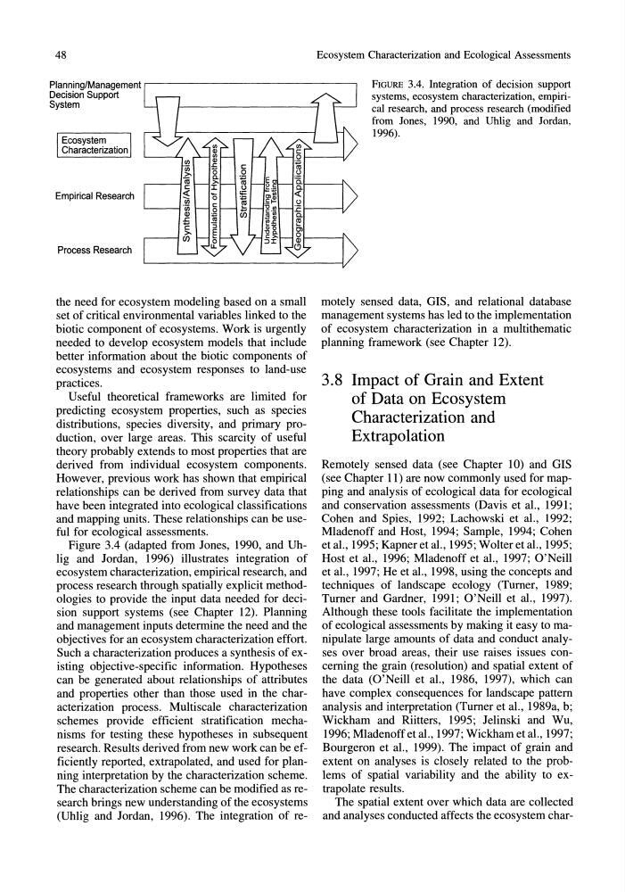
Planning/Management r - - - - - - - - - - - - - - - - - - , FIGURE 3.4. Integration of decision support
systems, ecosystem characterization, empirical research, and process research (modified
from Jones, 1990, and Uhlig and Jordan,
1996).
Decision Support
System
Ecosystem
Characterization
Empirical Research
Process Research
the need for ecosystem modeling based on a small
set of critical environmental variables linked to the
biotic component of ecosystems. Work is urgently
needed to develop ecosystem models that include
better information about the biotic components of
ecosystems and ecosystem responses to land-use
practices.
Useful theoretical frameworks are limited for
predicting ecosystem properties, such as species
distributions, species diversity, and primary production, over large areas. This scarcity of useful
theory probably extends to most properties that are
derived from individual ecosystem components.
However, previous work has shown that empirical
relationships can be derived from survey data that
have been integrated into ecological classifications
and mapping units. These relationships can be useful for ecological assessments.
Figure 3.4 (adapted from Jones, 1990, and Uhlig and Jordan, 1996) illustrates integration of
ecosystem characterization, empirical research, and
process research through spatially explicit methodologies to provide the input data needed for decision support systems (see Chapter 12). Planning
and management inputs determine the need and the
objectives for an ecosystem characterization effort.
Such a characterization produces a synthesis of existing objective-specific information. Hypotheses
can be generated about relationships of attributes
and properties other than those used in the characterization process. Multiscale characterization
schemes provide efficient stratification mechanisms for testing these hypotheses in subsequent
research. Results derived from new work can be efficiently reported, extrapolated, and used for planning interpretation by the characterization scheme.
The characterization scheme can be modified as research brings new understanding of the ecosystems
(Uhlig and Jordan, 1996). The integration of remotely sensed data, GIS, and relational database
management systems has led to the implementation
of ecosystem characterization in a multithematic
planning framework (see Chapter 12).
3.8 Impact of Grain and Extent
of Data on Ecosystem
Characterization and
Extrapolation
Remotely sensed data (see Chapter 10) and GIS
(see Chapter 11) are now commonly used for mapping and analysis of ecological data for ecological
and conservation assessments (Davis et al., 1991;
Cohen and Spies, 1992; Lachowski et aI., 1992;
Mladenoff and Host, 1994; Sample, 1994; Cohen
etaI., 1995; Kapneretal., 1995; Wolter et al., 1995;
Host et al., 1996; Mladenoff et al., 1997; O'Neill
et al., 1997; He et aI., 1998, using the concepts and
techniques of landscape ecology (Turner, 1989;
Turner and Gardner, 1991; O'Neill et al., 1997).
Although these tools facilitate the implementation
of ecological assessments by making it easy to manipulate large amounts of data and conduct analyses over broad areas, their use raises issues concerning the grain (resolution) and spatial extent of
the data (O'Neill et al., 1986, 1997), which can
have complex consequences for landscape pattern
analysis and interpretation (Turner et aI., 1989a, b;
Wickham and Riitters, 1995; Jelinski and Wu,
1996; Mladenoff etal., 1997; Wickham et al., 1997;
Bourgeron et al., 1999). The impact of grain and
extent on analyses is closely related to the problems of spatial variability and the ability to extrapolate results.
The spatial extent over which data are collected
and analyses conducted affects the ecosystem char-
Ecosystem Characterization and Ecological Assessments
Planning/Management r - - - - - - - - - - - - - - - - - - , FIGURE 3.4. Integration of decision support
systems, ecosystem characterization, empirical research, and process research (modified
from Jones, 1990, and Uhlig and Jordan,
1996).
Decision Support
System
Ecosystem
Characterization
Empirical Research
Process Research
the need for ecosystem modeling based on a small
set of critical environmental variables linked to the
biotic component of ecosystems. Work is urgently
needed to develop ecosystem models that include
better information about the biotic components of
ecosystems and ecosystem responses to land-use
practices.
Useful theoretical frameworks are limited for
predicting ecosystem properties, such as species
distributions, species diversity, and primary production, over large areas. This scarcity of useful
theory probably extends to most properties that are
derived from individual ecosystem components.
However, previous work has shown that empirical
relationships can be derived from survey data that
have been integrated into ecological classifications
and mapping units. These relationships can be useful for ecological assessments.
Figure 3.4 (adapted from Jones, 1990, and Uhlig and Jordan, 1996) illustrates integration of
ecosystem characterization, empirical research, and
process research through spatially explicit methodologies to provide the input data needed for decision support systems (see Chapter 12). Planning
and management inputs determine the need and the
objectives for an ecosystem characterization effort.
Such a characterization produces a synthesis of existing objective-specific information. Hypotheses
can be generated about relationships of attributes
and properties other than those used in the characterization process. Multiscale characterization
schemes provide efficient stratification mechanisms for testing these hypotheses in subsequent
research. Results derived from new work can be efficiently reported, extrapolated, and used for planning interpretation by the characterization scheme.
The characterization scheme can be modified as research brings new understanding of the ecosystems
(Uhlig and Jordan, 1996). The integration of remotely sensed data, GIS, and relational database
management systems has led to the implementation
of ecosystem characterization in a multithematic
planning framework (see Chapter 12).
3.8 Impact of Grain and Extent
of Data on Ecosystem
Characterization and
Extrapolation
Remotely sensed data (see Chapter 10) and GIS
(see Chapter 11) are now commonly used for mapping and analysis of ecological data for ecological
and conservation assessments (Davis et al., 1991;
Cohen and Spies, 1992; Lachowski et aI., 1992;
Mladenoff and Host, 1994; Sample, 1994; Cohen
etaI., 1995; Kapneretal., 1995; Wolter et al., 1995;
Host et al., 1996; Mladenoff et al., 1997; O'Neill
et al., 1997; He et aI., 1998, using the concepts and
techniques of landscape ecology (Turner, 1989;
Turner and Gardner, 1991; O'Neill et al., 1997).
Although these tools facilitate the implementation
of ecological assessments by making it easy to manipulate large amounts of data and conduct analyses over broad areas, their use raises issues concerning the grain (resolution) and spatial extent of
the data (O'Neill et al., 1986, 1997), which can
have complex consequences for landscape pattern
analysis and interpretation (Turner et aI., 1989a, b;
Wickham and Riitters, 1995; Jelinski and Wu,
1996; Mladenoff etal., 1997; Wickham et al., 1997;
Bourgeron et al., 1999). The impact of grain and
extent on analyses is closely related to the problems of spatial variability and the ability to extrapolate results.
The spatial extent over which data are collected
and analyses conducted affects the ecosystem char-