

464
Upper Mississippi River Adaptive Environmental Assessment
31.3.3 Spatial and Temporal Scale
for Modeling
Workshop participants agreed to take a system approach, with the system defined as the Upper Mississippi River from Minneapolis to its confluence
with the Ohio River. With this approach, modeling
would be confined to processes occurring within
the corridor of the floodplain, and processes occurring over the larger watershed or beyond would
not be directly modeled. However, factors not
specifically modeled can still be addressed by projecting how changes in these factors would affect
the model's driving variables (e.g., a change in land
use might increase demand for shipping and reduce
sediment input from tributaries). Participants also
determined that the minimum spatial scale for modeling within the river corridor must be small enough
to simulate changes in vegetation type and to represent major structures on the floodplain (e.g., levees, dams). The time frame for modeling must allow enough time for policies to produce effects
(perhaps 50 to 100 years), yet be short enough to
capture seasonal effects in components such as vegetation growth, ice-up, winter habitat for fish, and
shipping. It was agreed that the model would not
consider short-term effects such as barge passage
or wake effects from recreational craft. Even within
these temporal and spatial restrictions, it was recognized that the proposed model would be too
large. Participants concurred with the modeling
consultants' recommendation to develop two models: a river system model that could span the entire
"%"9'&1
2 Questions
Throughput
Science·based
modeling of
ecology and
economy
UMR and a pool-scale model to capture finer details.
31.4 Developing the Model
A unique characteristic of the AEA process is the
use of computer models to help integrate and test
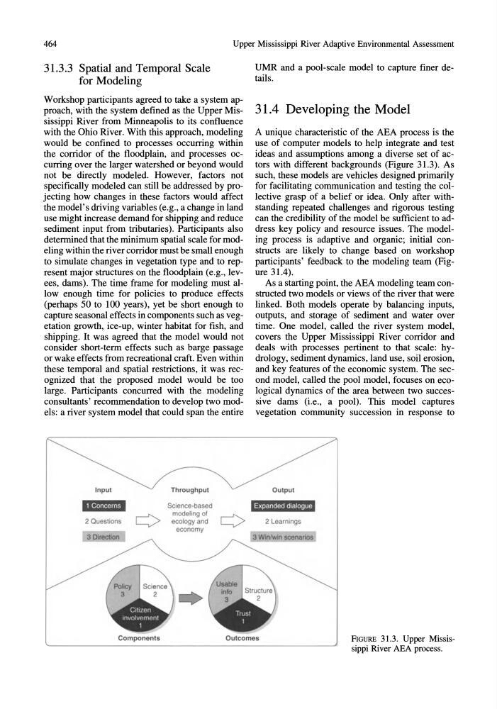
ideas and assumptions among a diverse set of actors with different backgrounds (Figure 31.3). As
such, these models are vehicles designed primarily
for facilitating communication and testing the collective grasp of a belief or idea. Only after withstanding repeated challenges and rigorous testing
can the credibility of the model be sufficient to address key policy and resource issues. The modeling process is adaptive and organic; initial constructs are likely to change based on workshop
participants' feedback to the modeling team (Figure 31.4).
As a starting point, the AEA modeling team constructed two models or views of the river that were
linked. Both models operate by balancing inputs,
outputs, and storage of sediment and water over
time. One model, called the river system model,
covers the Upper Mississippi River corridor and
deals with processes pertinent to that scale: hydrology, sediment dynamics, land use, soil erosion,
and key features of the economic system. The second model, called the pool model, focuses on ecological dynamics of the area between two successive dams (i.e., a pool). This model captures
vegetation community succession in response to
2 Learnings
Components
Outcomes
FIGURE 31.3. Upper Mississippi River AEA process.
Upper Mississippi River Adaptive Environmental Assessment
31.3.3 Spatial and Temporal Scale
for Modeling
Workshop participants agreed to take a system approach, with the system defined as the Upper Mississippi River from Minneapolis to its confluence
with the Ohio River. With this approach, modeling
would be confined to processes occurring within
the corridor of the floodplain, and processes occurring over the larger watershed or beyond would
not be directly modeled. However, factors not
specifically modeled can still be addressed by projecting how changes in these factors would affect
the model's driving variables (e.g., a change in land
use might increase demand for shipping and reduce
sediment input from tributaries). Participants also
determined that the minimum spatial scale for modeling within the river corridor must be small enough
to simulate changes in vegetation type and to represent major structures on the floodplain (e.g., levees, dams). The time frame for modeling must allow enough time for policies to produce effects
(perhaps 50 to 100 years), yet be short enough to
capture seasonal effects in components such as vegetation growth, ice-up, winter habitat for fish, and
shipping. It was agreed that the model would not
consider short-term effects such as barge passage
or wake effects from recreational craft. Even within
these temporal and spatial restrictions, it was recognized that the proposed model would be too
large. Participants concurred with the modeling
consultants' recommendation to develop two models: a river system model that could span the entire
"%"9'&1
2 Questions
Throughput
Science·based
modeling of
ecology and
economy
UMR and a pool-scale model to capture finer details.
31.4 Developing the Model
A unique characteristic of the AEA process is the
use of computer models to help integrate and test
ideas and assumptions among a diverse set of actors with different backgrounds (Figure 31.3). As
such, these models are vehicles designed primarily
for facilitating communication and testing the collective grasp of a belief or idea. Only after withstanding repeated challenges and rigorous testing
can the credibility of the model be sufficient to address key policy and resource issues. The modeling process is adaptive and organic; initial constructs are likely to change based on workshop
participants' feedback to the modeling team (Figure 31.4).
As a starting point, the AEA modeling team constructed two models or views of the river that were
linked. Both models operate by balancing inputs,
outputs, and storage of sediment and water over
time. One model, called the river system model,
covers the Upper Mississippi River corridor and
deals with processes pertinent to that scale: hydrology, sediment dynamics, land use, soil erosion,
and key features of the economic system. The second model, called the pool model, focuses on ecological dynamics of the area between two successive dams (i.e., a pool). This model captures
vegetation community succession in response to
2 Learnings
Components
Outcomes
FIGURE 31.3. Upper Mississippi River AEA process.