

452
The Great Lakes Ecological Assessment
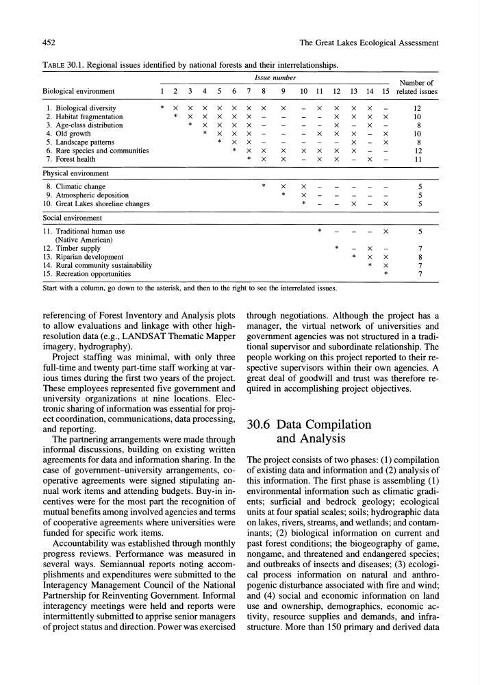
TABLE 30.1. Regional issues identified by national forests and their interrelationships.
Issue number
Number of
Biological environment
2 3 4 5
6 7
8
9
10 11 12 13 14 15 related issues
1. Biological diversity
* X X X X X X X
X
X
X
X
X
12
2. Habitat fragmentation
* X X X X X
X
X
X
X
10
3. Age-class distribution
* X X X X
X
X
8
4. Old growth
* X X X
X
X
X
X
10
5. Landscape patterns
* X X
X
X
8
6. Rare species and communities
* X X
X
X
X
X
X
12
7. Forest health
* X
X
X
X
X
11
Physical environment
8. Climatic change
* X
X
5
9. Atmospheric deposition
*
X
5
10. Great Lakes shoreline changes
*
X
X
5
Social environment
11. Traditional human use
*
X
5
(Native American)
12. Timber supply
*
X
7
13. Riparian development
* X X
8
14. Rural community sustainability
* X
7
15. Recreation opportunities
*
7
Start with a column, go down to the asterisk, and then to the right to see the interrelated issues.
referencing of Forest Inventory and Analysis plots
to allow evaluations and linkage with other highresolution data (e.g., LANDSAT Thematic Mapper
imagery, hydrography).
Project staffing was minimal, with only three
full-time and twenty part-time staff working at various times during the first two years of the project.
These employees represented five government and
university organizations at nine locations. Electronic sharing of information was essential for project coordination, communications, data processing,
and reporting.
The partnering arrangements were made through
informal discussions, building on existing written
agreements for data and information sharing. In the
case of government-university arrangements, cooperative agreements were signed stipulating annual work items and attending budgets. Buy-in incentives were for the most part the recognition of
mutual benefits among involved agencies and terms
of cooperative agreements where universities were
funded for specific work items.
Accountability was established through monthly
progress reviews. Performance was measured in
several ways. Semiannual reports noting accomplishments and expenditures were submitted to the
Interagency Management Council of the National
Partnership for Reinventing Government. Informal
interagency meetings were held and reports were
intermittently submitted to apprise senior managers
of project status and direction. Power was exercised
through negotiations. Although the project has a
manager, the virtual network of universities and
government agencies was not structured in a traditional supervisor and subordinate relationship. The
people working on this project reported to their respective supervisors within their own agencies. A
great deal of goodwill and trust was therefore required in accomplishing project objectives.
30.6 Data Compilation
and Analysis
The project consists of two phases: (l) compilation
of existing data and information and (2) analysis of
this information. The first phase is assembling (1)
environmental information such as climatic gradients; surficial and bedrock geology; ecological
units at four spatial scales; soils; hydrographic data
on lakes, rivers, streams, and wetlands; and contaminants; (2) biological information on current and
past forest conditions; the biogeography of game,
nongame, and threatened and endangered species;
and outbreaks of insects and diseases; (3) ecological process information on natural and anthropogenic disturbance associated with fire and wind;
and (4) social and economic information on land
use and ownership, demographics, economic activity, resource supplies and demands, and infrastructure. More than 150 primary and derived data
The Great Lakes Ecological Assessment
TABLE 30.1. Regional issues identified by national forests and their interrelationships.
Issue number
Number of
Biological environment
2 3 4 5
6 7
8
9
10 11 12 13 14 15 related issues
1. Biological diversity
* X X X X X X X
X
X
X
X
X
12
2. Habitat fragmentation
* X X X X X
X
X
X
X
10
3. Age-class distribution
* X X X X
X
X
8
4. Old growth
* X X X
X
X
X
X
10
5. Landscape patterns
* X X
X
X
8
6. Rare species and communities
* X X
X
X
X
X
X
12
7. Forest health
* X
X
X
X
X
11
Physical environment
8. Climatic change
* X
X
5
9. Atmospheric deposition
*
X
5
10. Great Lakes shoreline changes
*
X
X
5
Social environment
11. Traditional human use
*
X
5
(Native American)
12. Timber supply
*
X
7
13. Riparian development
* X X
8
14. Rural community sustainability
* X
7
15. Recreation opportunities
*
7
Start with a column, go down to the asterisk, and then to the right to see the interrelated issues.
referencing of Forest Inventory and Analysis plots
to allow evaluations and linkage with other highresolution data (e.g., LANDSAT Thematic Mapper
imagery, hydrography).
Project staffing was minimal, with only three
full-time and twenty part-time staff working at various times during the first two years of the project.
These employees represented five government and
university organizations at nine locations. Electronic sharing of information was essential for project coordination, communications, data processing,
and reporting.
The partnering arrangements were made through
informal discussions, building on existing written
agreements for data and information sharing. In the
case of government-university arrangements, cooperative agreements were signed stipulating annual work items and attending budgets. Buy-in incentives were for the most part the recognition of
mutual benefits among involved agencies and terms
of cooperative agreements where universities were
funded for specific work items.
Accountability was established through monthly
progress reviews. Performance was measured in
several ways. Semiannual reports noting accomplishments and expenditures were submitted to the
Interagency Management Council of the National
Partnership for Reinventing Government. Informal
interagency meetings were held and reports were
intermittently submitted to apprise senior managers
of project status and direction. Power was exercised
through negotiations. Although the project has a
manager, the virtual network of universities and
government agencies was not structured in a traditional supervisor and subordinate relationship. The
people working on this project reported to their respective supervisors within their own agencies. A
great deal of goodwill and trust was therefore required in accomplishing project objectives.
30.6 Data Compilation
and Analysis
The project consists of two phases: (l) compilation
of existing data and information and (2) analysis of
this information. The first phase is assembling (1)
environmental information such as climatic gradients; surficial and bedrock geology; ecological
units at four spatial scales; soils; hydrographic data
on lakes, rivers, streams, and wetlands; and contaminants; (2) biological information on current and
past forest conditions; the biogeography of game,
nongame, and threatened and endangered species;
and outbreaks of insects and diseases; (3) ecological process information on natural and anthropogenic disturbance associated with fire and wind;
and (4) social and economic information on land
use and ownership, demographics, economic activity, resource supplies and demands, and infrastructure. More than 150 primary and derived data