

450
This situation led to duplicative efforts by employees in various federal and state agencies to develop information to meet their particular needs, resulting in inefficiencies and undue expenses.
Furthermore, gaps in data and application methodology made data sharing among mUltiple agencies
difficult and, in some cases, scientifically indefensible. Although many interrelated conditions and
trends, such as demand for and supply of commodities and amenities, cross administrative and
state boundaries, regionwide databases were not
widely available. Finally, recent technological advances, including telecommunications, geographic
information systems, and microcomputers, presented opportunities for assembling and distributing information that were not formerly possible.
These conditions provided the impetus for the
GLA.
The overall goals of the GLA are to cost effectively develop a comprehensive knowledge base for
integrated resource planning and management and
to provide a scientific basis for inventory, planning,
management, and monitoring activities. An emphasis must be added that the GLA is not a federal
decision-making process under the National Environmental Policy Act (NEP A), but rather organizes
/\1 ~ubo.mon,
alb vegetation (Grouped 10 F1A <:alegories)
White, ~ end 10ck Pin.
Spruce, Fir
001<, Hiclcory
Elm, Ash. and Cottonwood
Maple, ll«ch, end Birch
Apen, Birch
Nonf~led
W.ler
The Great Lakes Ecological Assessment
existing information and provides new information
that may be considered in the NEP A process.
The GLA is an ongoing assessment and is notably different from its predecessors (see other case
studies in this volume). The focus for the GLA is
providing information that may be used by federal
agencies in revising individual National Forest
plans and environmental impact statements, state
and local governments for planning purposes, and
other groups or individuals needing information
about the region's forests.
30.3 Scope and Location
A crucial decision for any assessment is delineation
of the region, or the assessment and analysis area.
In the case of the GLA, the regions of analysis were
delineated within the context of the Forest Service's National Hierarchical Framework of Ecological Units (Cleland et aI., 1997), a system
adopted by federal and state agencies across the
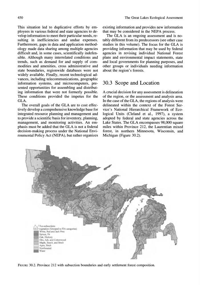
Lake States. The GLA encompasses 98,000 square
miles within Province 212, the Laurentian mixed
forest, in northern Minnesota, Wisconsin, and
Michigan (Figure 30.2).
FIGURE 30.2. Province 212 with subsection boundaries and early settlement forest composition.
This situation led to duplicative efforts by employees in various federal and state agencies to develop information to meet their particular needs, resulting in inefficiencies and undue expenses.
Furthermore, gaps in data and application methodology made data sharing among mUltiple agencies
difficult and, in some cases, scientifically indefensible. Although many interrelated conditions and
trends, such as demand for and supply of commodities and amenities, cross administrative and
state boundaries, regionwide databases were not
widely available. Finally, recent technological advances, including telecommunications, geographic
information systems, and microcomputers, presented opportunities for assembling and distributing information that were not formerly possible.
These conditions provided the impetus for the
GLA.
The overall goals of the GLA are to cost effectively develop a comprehensive knowledge base for
integrated resource planning and management and
to provide a scientific basis for inventory, planning,
management, and monitoring activities. An emphasis must be added that the GLA is not a federal
decision-making process under the National Environmental Policy Act (NEP A), but rather organizes
/\1 ~ubo.mon,
alb vegetation (Grouped 10 F1A <:alegories)
White, ~ end 10ck Pin.
Spruce, Fir
001<, Hiclcory
Elm, Ash. and Cottonwood
Maple, ll«ch, end Birch
Apen, Birch
Nonf~led
W.ler
The Great Lakes Ecological Assessment
existing information and provides new information
that may be considered in the NEP A process.
The GLA is an ongoing assessment and is notably different from its predecessors (see other case
studies in this volume). The focus for the GLA is
providing information that may be used by federal
agencies in revising individual National Forest
plans and environmental impact statements, state
and local governments for planning purposes, and
other groups or individuals needing information
about the region's forests.
30.3 Scope and Location
A crucial decision for any assessment is delineation
of the region, or the assessment and analysis area.
In the case of the GLA, the regions of analysis were
delineated within the context of the Forest Service's National Hierarchical Framework of Ecological Units (Cleland et aI., 1997), a system
adopted by federal and state agencies across the
Lake States. The GLA encompasses 98,000 square
miles within Province 212, the Laurentian mixed
forest, in northern Minnesota, Wisconsin, and
Michigan (Figure 30.2).
FIGURE 30.2. Province 212 with subsection boundaries and early settlement forest composition.