

380
Geomorphic Patterns, Processes, and Perspectives in Aquatic Assessment
landtype
Association
Walo,ohod and $ogmonl
Ponurbation and Oovolopmonlal
Slatos
.... - ....
. .
. .
,
.
I
•
. .
.-""', ... -.... ,~
. ' .
Obsorvod
Habitat
Slatos
..- ....
· .
· .
· .
. .
'T"
,
.. '
...... ·.r .... c....~
o#J'--' ... " .. -"- ___ J:
........... State
I '
' .
""...
,l1li'-......
'II
3
-----~
:
..........
".
\.
I'
\.
II
. . ,
. . ~
..... -
"-~
Time
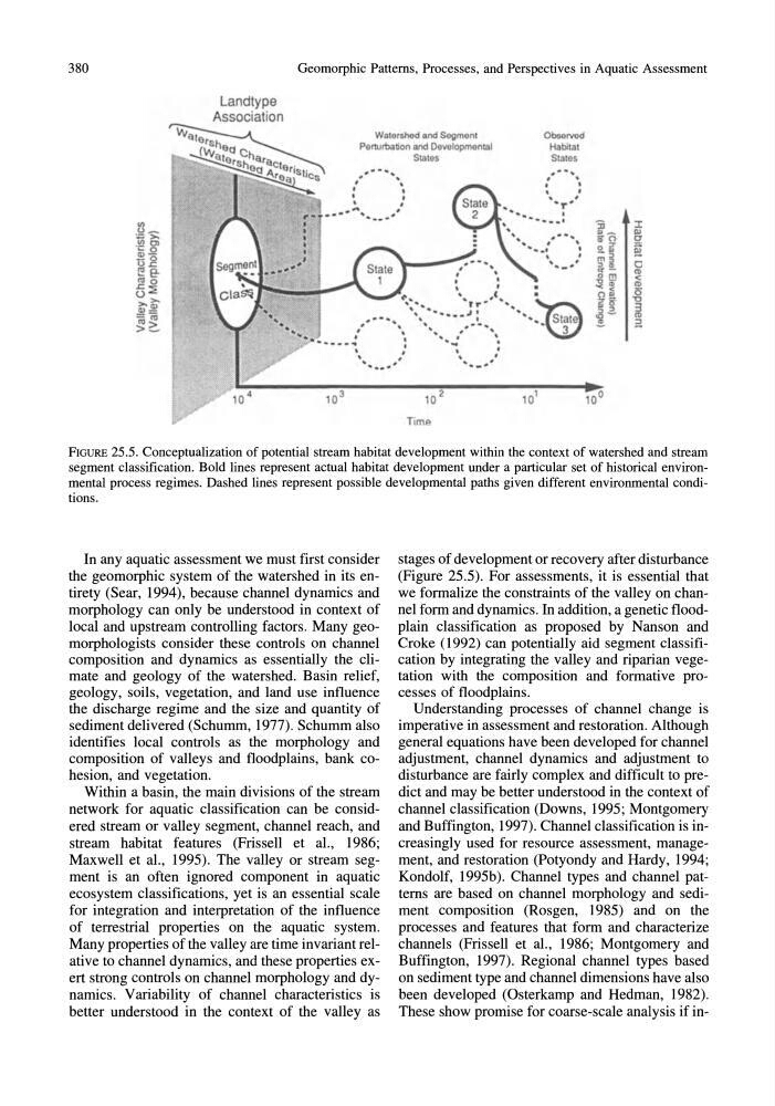
FIGURE 25.5. Conceptualization of potential stream habitat development within the context of watershed and stream
segment classification. Bold lines represent actual habitat development under a particular set of historical environmental process regimes. Dashed lines represent possible developmental paths given different environmental conditions.
In any aquatic assessment we must first consider
the geomorphic system of the watershed in its entirety (Sear, 1994), because channel dynamics and
morphology can only be understood in context of
local and upstream controlling factors. Many geomorphologists consider these controls on channel
composition and dynamics as essentially the climate and geology of the watershed. Basin relief,
geology, soils, vegetation, and land use influence
the discharge regime and the size and quantity of
sediment delivered (Schumm, 1977). Schumm also
identifies local controls as the morphology and
composition of valleys and floodplains, bank cohesion, and vegetation.
Within a basin, the main divisions of the stream
network for aquatic classification can be considered stream or valley segment, channel reach, and
stream habitat features (Frissell et aI., 1986;
Maxwell et aI., 1995). The valley or stream segment is an often ignored component in aquatic
ecosystem classifications, yet is an essential scale
for integration and interpretation of the influence
of terrestrial properties on the aquatic system.
Many properties of the valley are time invariant relative to channel dynamics, and these properties exert strong controls on channel morphology and dynamics. Variability of channel characteristics is
better understood in the context of the valley as
stages of development or recovery after disturbance
(Figure 25.5). For assessments, it is essential that
we formalize the constraints of the valley on channel form and dynamics. In addition, a genetic floodplain classification as proposed by Nanson and
Croke (1992) can potentially aid segment classification by integrating the valley and riparian vegetation with the composition and formative processes of floodplains.
Understanding processes of channel change is
imperative in assessment and restoration. Although
general equations have been developed for channel
adjustment, channel dynamics and adjustment to
disturbance are fairly complex and difficult to predict and may be better understood in the context of
channel classification (Downs, 1995; Montgomery
and Buffington, 1997). Channel classification is increasingly used for resource assessment, management, and restoration (Potyondy and Hardy, 1994;
Kondolf, 1995b). Channel types and channel patterns are based on channel morphology and sediment composition (Rosgen, 1985) and on the
processes and features that form and characterize
channels (Frissell· et aI., 1986; Montgomery and
Buffington, 1997). Regional channel types based
on sediment type and channel dimensions have also
been developed (Osterkamp and Hedman, 1982).
These show promise for coarse-scale analysis if in-
Geomorphic Patterns, Processes, and Perspectives in Aquatic Assessment
landtype
Association
Walo,ohod and $ogmonl
Ponurbation and Oovolopmonlal
Slatos
.... - ....
. .
. .
,
.
I
•
. .
.-""', ... -.... ,~
. ' .
Obsorvod
Habitat
Slatos
..- ....
· .
· .
· .
. .
'T"
,
.. '
...... ·.r .... c....~
o#J'--' ... " .. -"- ___ J:
........... State
I '
' .
""...
,l1li'-......
'II
3
-----~
:
..........
".
\.
I'
\.
II
. . ,
. . ~
..... -
"-~
Time
FIGURE 25.5. Conceptualization of potential stream habitat development within the context of watershed and stream
segment classification. Bold lines represent actual habitat development under a particular set of historical environmental process regimes. Dashed lines represent possible developmental paths given different environmental conditions.
In any aquatic assessment we must first consider
the geomorphic system of the watershed in its entirety (Sear, 1994), because channel dynamics and
morphology can only be understood in context of
local and upstream controlling factors. Many geomorphologists consider these controls on channel
composition and dynamics as essentially the climate and geology of the watershed. Basin relief,
geology, soils, vegetation, and land use influence
the discharge regime and the size and quantity of
sediment delivered (Schumm, 1977). Schumm also
identifies local controls as the morphology and
composition of valleys and floodplains, bank cohesion, and vegetation.
Within a basin, the main divisions of the stream
network for aquatic classification can be considered stream or valley segment, channel reach, and
stream habitat features (Frissell et aI., 1986;
Maxwell et aI., 1995). The valley or stream segment is an often ignored component in aquatic
ecosystem classifications, yet is an essential scale
for integration and interpretation of the influence
of terrestrial properties on the aquatic system.
Many properties of the valley are time invariant relative to channel dynamics, and these properties exert strong controls on channel morphology and dynamics. Variability of channel characteristics is
better understood in the context of the valley as
stages of development or recovery after disturbance
(Figure 25.5). For assessments, it is essential that
we formalize the constraints of the valley on channel form and dynamics. In addition, a genetic floodplain classification as proposed by Nanson and
Croke (1992) can potentially aid segment classification by integrating the valley and riparian vegetation with the composition and formative processes of floodplains.
Understanding processes of channel change is
imperative in assessment and restoration. Although
general equations have been developed for channel
adjustment, channel dynamics and adjustment to
disturbance are fairly complex and difficult to predict and may be better understood in the context of
channel classification (Downs, 1995; Montgomery
and Buffington, 1997). Channel classification is increasingly used for resource assessment, management, and restoration (Potyondy and Hardy, 1994;
Kondolf, 1995b). Channel types and channel patterns are based on channel morphology and sediment composition (Rosgen, 1985) and on the
processes and features that form and characterize
channels (Frissell· et aI., 1986; Montgomery and
Buffington, 1997). Regional channel types based
on sediment type and channel dimensions have also
been developed (Osterkamp and Hedman, 1982).
These show promise for coarse-scale analysis if in-