

25.4 Hydrological Processes
flows are linked to the nature of climatic mechanisms (Hirschboeck, 1988); furthermore, the slope
of flood frequency curves reflects the variability of
flood-producing climactic mechanisms (Pitlick,
1994). Flow duration curves represent cumulative
frequencies of all flows and are viewed as the percentage of time that certain flow events are exceeded. The shape, slope, and log plot of the curve
are related to both the variability of flows and flowgenerating processes. The flow duration curve is
particularly useful for interpreting low-flow characteristics and for assessing the impact of factors
such as groundwater, water diversions, and reservoirs. Base flows are also characterized from flow
recession curves, low-flow frequency curves and
from a Base Flow Index (Rogers and Armbruster,
1990; Gustard, 1992). Base flows in tum have been
used to determine groundwater aquifer contribution
to catchment hydrology (Johnston, 1971), as exemplified by a proposed geologic low-flow index
(Brown, 1981). A simple metric of flow variability is the ratio of lOO-year flood (or base flow) to
the mean annual discharge. This ratio also scales
flow events to relative geomorphic effectiveness
(Wolman and Gerson, 1978). The annual flow
regime reflects the influence of climatic processes
on seasonal flow development and is useful for understanding seasonal behavior, distribution, and life
histories of aquatic organisms. Flow regime types
show particular promise for ecological assessments, because they reflect flow variability from
factors such as snow melt, rain on snow, precipitation, and groundwater. Such flow regime types
have been developed for the United States (Poff,
1996) and the Columbia River Basin (Quigley and
Arbelbide, 1997).
TRANSPIRATION
371
Hydrological regions have been established at
various scales, often oriented toward management
interests such as culvert design and flood hazard.
Geographic extrapolation of flood frequency relations (summarized by Jennings et aI., 1994) is one
of many methods used to establish hydrologic regions. Other classifications that are more oriented
for ecosystem assessments include a hierarchical,
hydrogeophysical watershed classification of the
Columbia River Basin (Quigley and Arbelbide,
1997). Also of use in assessments are hydrogeomorphic regions of the United States that relate
physiographic and climatic influences on groundwater properties (Heath, 1984; Coates, 1990a).
Finer-scale physiographic subregions refine groundwater relations with geologic processes and bedrock and surface geology (Coates, 1974).
25.4.3 Biophysical Factors and the
Hydrological Cycle
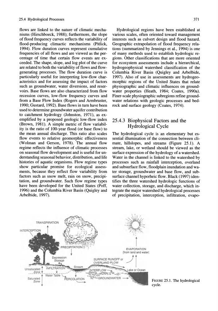
The hydrological cycle is an elementary but essential illumination of the connection between climate, hillslopes, and streams (Figure 25.1). A
stream, lake, or wetland should be viewed as the
surface expression of the hydrology of a watershed.
Water in the channel is linked to the watershed by
processes such as rainfall interception, overland
and subsurface flow, floodplain inundation and water storage, groundwater and base flow, and subsurface channel hyporheic flow. Black (1997) identifies the three watershed hydrologic functions of
water collection, storage, and discharge, which integrate the major watershed hydrological processes
of precipitation, interception, infiltration, evapoi
EVAPORATION
(from land and water]
SURFACE RUNOFF or
t t
~;;;Jtl~m~~~~;-.;~~ OVERLAND ~.../ I
un~~t~~a~~J _ _ _ _ _ _ _ _ _ _ _
or Ocean
1
Water Table '-...
Saturated
PERCOLAnON
Zone
' -
FIGURE 25.1. The hydrological
cycle.
flows are linked to the nature of climatic mechanisms (Hirschboeck, 1988); furthermore, the slope
of flood frequency curves reflects the variability of
flood-producing climactic mechanisms (Pitlick,
1994). Flow duration curves represent cumulative
frequencies of all flows and are viewed as the percentage of time that certain flow events are exceeded. The shape, slope, and log plot of the curve
are related to both the variability of flows and flowgenerating processes. The flow duration curve is
particularly useful for interpreting low-flow characteristics and for assessing the impact of factors
such as groundwater, water diversions, and reservoirs. Base flows are also characterized from flow
recession curves, low-flow frequency curves and
from a Base Flow Index (Rogers and Armbruster,
1990; Gustard, 1992). Base flows in tum have been
used to determine groundwater aquifer contribution
to catchment hydrology (Johnston, 1971), as exemplified by a proposed geologic low-flow index
(Brown, 1981). A simple metric of flow variability is the ratio of lOO-year flood (or base flow) to
the mean annual discharge. This ratio also scales
flow events to relative geomorphic effectiveness
(Wolman and Gerson, 1978). The annual flow
regime reflects the influence of climatic processes
on seasonal flow development and is useful for understanding seasonal behavior, distribution, and life
histories of aquatic organisms. Flow regime types
show particular promise for ecological assessments, because they reflect flow variability from
factors such as snow melt, rain on snow, precipitation, and groundwater. Such flow regime types
have been developed for the United States (Poff,
1996) and the Columbia River Basin (Quigley and
Arbelbide, 1997).
TRANSPIRATION
371
Hydrological regions have been established at
various scales, often oriented toward management
interests such as culvert design and flood hazard.
Geographic extrapolation of flood frequency relations (summarized by Jennings et aI., 1994) is one
of many methods used to establish hydrologic regions. Other classifications that are more oriented
for ecosystem assessments include a hierarchical,
hydrogeophysical watershed classification of the
Columbia River Basin (Quigley and Arbelbide,
1997). Also of use in assessments are hydrogeomorphic regions of the United States that relate
physiographic and climatic influences on groundwater properties (Heath, 1984; Coates, 1990a).
Finer-scale physiographic subregions refine groundwater relations with geologic processes and bedrock and surface geology (Coates, 1974).
25.4.3 Biophysical Factors and the
Hydrological Cycle
The hydrological cycle is an elementary but essential illumination of the connection between climate, hillslopes, and streams (Figure 25.1). A
stream, lake, or wetland should be viewed as the
surface expression of the hydrology of a watershed.
Water in the channel is linked to the watershed by
processes such as rainfall interception, overland
and subsurface flow, floodplain inundation and water storage, groundwater and base flow, and subsurface channel hyporheic flow. Black (1997) identifies the three watershed hydrologic functions of
water collection, storage, and discharge, which integrate the major watershed hydrological processes
of precipitation, interception, infiltration, evapoi
EVAPORATION
(from land and water]
SURFACE RUNOFF or
t t
~;;;Jtl~m~~~~;-.;~~ OVERLAND ~.../ I
un~~t~~a~~J _ _ _ _ _ _ _ _ _ _ _
or Ocean
1
Water Table '-...
Saturated
PERCOLAnON
Zone
' -
FIGURE 25.1. The hydrological
cycle.