

362
Ecological Classification and Mapping of Aquatic Systems
0
I
@lvId~
10 1
Channel
~
~
~poPula~
10 3
10 6
10 9
2
Meters
River
Unit
I Reacb I Watersbed I Basin
(a) Fish Distribution Patterns
Cbannel
I Unit
10 3
10 6
2
Meters
I Reaeb I Watersbed I
River
Basin
(c) Disturbance Processes
101
0
I
o
~
~
~enta~
10 1
10 3
10 6
10 9
Meters
2
Cbannel
River
Unit
I Reaeb I Watersbed I BasIn
(b) Biotic Processes
~
~
GRegloaaD almate
10 3
10 6
Cbannel
I Unit
2
Meters
I Reaeb I Watersbed I
River
Basin
(d) Environmental Constraints
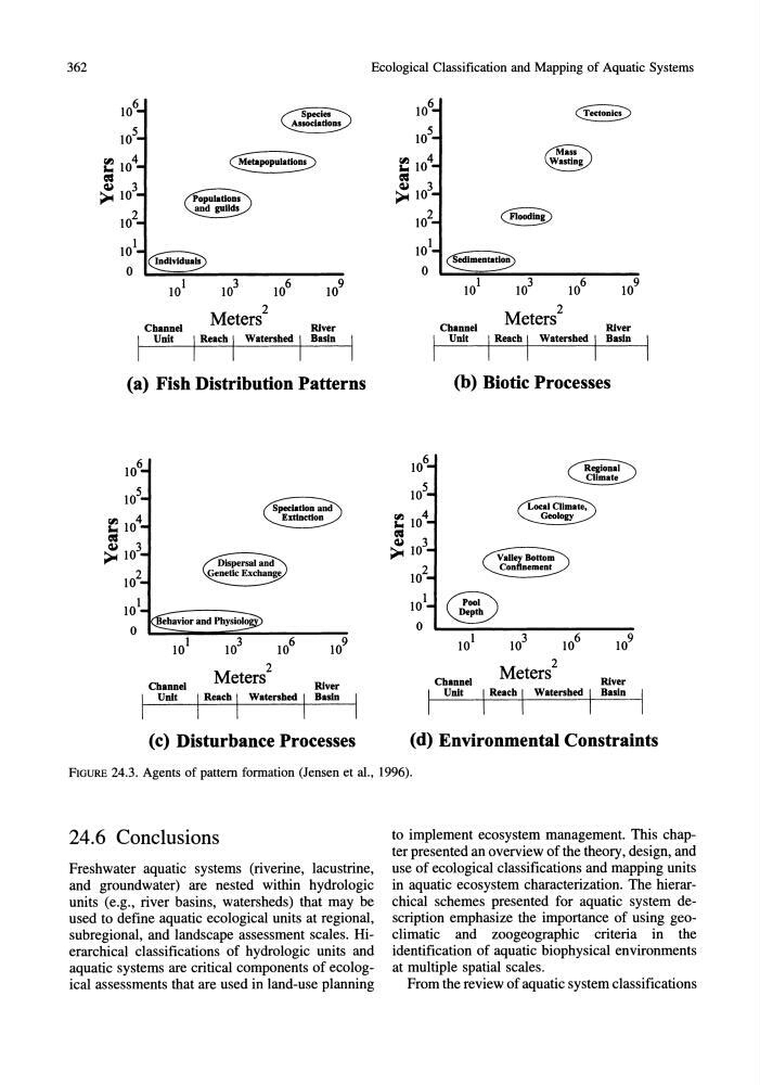
FIGURE 24.3. Agents of pattern formation (Jensen et al., 1996).
24.6 Conclusions
Freshwater aquatic systems (riverine, lacustrine,
and groundwater) are nested within hydrologic
units (e.g., river basins, watersheds) that may be
used to define aquatic ecological units at regional,
subregional, and landscape assessment scales. Hierarchical classifications of hydrologic units and
aquatic systems are critical components of ecological assessments that are used in land-use planning
to implement ecosystem management. This chapter presented an overview of the theory, design, and
use of ecological classifications and mapping units
in aquatic ecosystem characterization. The hierarchical schemes presented for aquatic system description emphasize the importance of using geoclimatic and zoogeographic criteria in the
identification of aquatic biophysical environments
at multiple spatial scales.
From the review of aquatic system classifications
Ecological Classification and Mapping of Aquatic Systems
0
I
@lvId~
10 1
Channel
~
~
~poPula~
10 3
10 6
10 9
2
Meters
River
Unit
I Reacb I Watersbed I Basin
(a) Fish Distribution Patterns
Cbannel
I Unit
10 3
10 6
2
Meters
I Reaeb I Watersbed I
River
Basin
(c) Disturbance Processes
101
0
I
o
~
~
~enta~
10 1
10 3
10 6
10 9
Meters
2
Cbannel
River
Unit
I Reaeb I Watersbed I BasIn
(b) Biotic Processes
~
~
GRegloaaD almate
10 3
10 6
Cbannel
I Unit
2
Meters
I Reaeb I Watersbed I
River
Basin
(d) Environmental Constraints
FIGURE 24.3. Agents of pattern formation (Jensen et al., 1996).
24.6 Conclusions
Freshwater aquatic systems (riverine, lacustrine,
and groundwater) are nested within hydrologic
units (e.g., river basins, watersheds) that may be
used to define aquatic ecological units at regional,
subregional, and landscape assessment scales. Hierarchical classifications of hydrologic units and
aquatic systems are critical components of ecological assessments that are used in land-use planning
to implement ecosystem management. This chapter presented an overview of the theory, design, and
use of ecological classifications and mapping units
in aquatic ecosystem characterization. The hierarchical schemes presented for aquatic system description emphasize the importance of using geoclimatic and zoogeographic criteria in the
identification of aquatic biophysical environments
at multiple spatial scales.
From the review of aquatic system classifications