

12.5 Comparison of Existing Ecosystem Management DSS
173
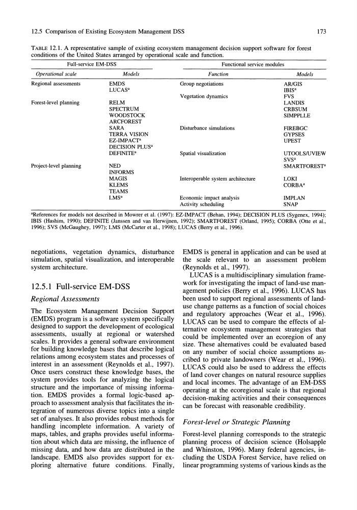
TABLE 12.1. A representative sample of existing ecosystem management decision support software for forest
conditions of the United States arranged by operational scale and function.
Full-service EM-DSS
Operational scale
Regional assessments
Forest-level planning
Project-level planning
Models
EMDS
LUCAS"
RELM
SPECTRUM
WOODSTOCK
ARCFOREST
SARA
TERRA VISION
EZ-IMPACTa
DECISION PLUS"
DEFINITE"
NED
INFORMS
MAGIS
KLEMS
TEAMS
LMS"
Functional service modules
Function
Group negotiations
Vegetation dynamics
Disturbance simulations
Spatial visualization
Interoperable system architecture
Economic impact analysis
Activity scheduling
Models
ARlGIS
IBIS"
FVS
LANDIS
CRBSUM
SIMPPLLE
FIREBGC
GYPSES
UPEST
UTOOLS/uVIEW
SVS"
SMARTFOREST"
LOKI
CORBA"
IMPLAN
SNAP
"References for models not described in Mowrer et al. (1997): EZ-IMPACT (Behan, 1994); DECISION PLUS (Sygenex, 1994);
mIS (Hashim, 1990); DEFINITE (Janssen and van Herwijnen, 1992); SMARTFOREST (Orland, 1995); CORBA (Otte et aI.,
1996); SVS (McGaughey, 1997); LMS (McCarter et al., 1998); LUCAS (Berry et al., 1996).
negotiations, vegetation dynamics, disturbance
simulation, spatial visualization, and interoperable
system architecture.
12.5.1 Full-service EM-DSS
Regional Assessments
The Ecosystem Management Decision Support
(EMDS) program is a software system specifically
designed to support the development of ecological
assessments, usually at regional or watershed
scales. It provides a general software environment
for building knowledge bases that describe logical
relations among ecosystem states and processes of
interest in an assessment (Reynolds et aI., 1997).
Once users construct these knowledge bases, the
system provides tools for analyzing the logical
structure and the importance of missing information. EMDS provides a formal logic-based approach to assessment analysis that facilitates the integration of numerous diverse topics into a single
set of analyses. It also provides robust methods for
handling incomplete information. A variety of
maps, tables, and graphs provides useful information about which data are missing, the influence of
missing data, and how data are distributed in the
landscape. EMDS also provides support for exploring alternative future conditions. Finally,
EMDS is general in application and can be used at
the scale relevant to an assessment problem
(Reynolds et aI., 1997).
LUCAS is a multidisciplinary simulation framework for investigating the impact of land-use management policies (Berry et al., 1996). LUCAS has
been used to support regional assessments of landuse change patterns as a function of social choices
and regulatory approaches (Wear et al., 1996).
LUCAS can be used to compare the effects of alternative ecosystem management strategies that
could be implemented over an ecoregion of any
size. These alternatives could be evaluated based
on any number of social choice assumptions ascribed to private landowners (Wear et al., 1996).
LUCAS could also be used to address the effects
of land cover changes on natural resource supplies
and local incomes. The advantage of an EM-DSS
operating at the ecoregional scale is that regional
decision-making activities and their consequences
can be forecast with reasonable credibility.
Forest-level or Strategic Planning
Forest-level planning corresponds to the strategic
planning process of decision science (Holsapple
and Whinston, 1996). Many federal agencies, including the USDA Forest Service, have relied on
linear programming systems of various kinds as the
173
TABLE 12.1. A representative sample of existing ecosystem management decision support software for forest
conditions of the United States arranged by operational scale and function.
Full-service EM-DSS
Operational scale
Regional assessments
Forest-level planning
Project-level planning
Models
EMDS
LUCAS"
RELM
SPECTRUM
WOODSTOCK
ARCFOREST
SARA
TERRA VISION
EZ-IMPACTa
DECISION PLUS"
DEFINITE"
NED
INFORMS
MAGIS
KLEMS
TEAMS
LMS"
Functional service modules
Function
Group negotiations
Vegetation dynamics
Disturbance simulations
Spatial visualization
Interoperable system architecture
Economic impact analysis
Activity scheduling
Models
ARlGIS
IBIS"
FVS
LANDIS
CRBSUM
SIMPPLLE
FIREBGC
GYPSES
UPEST
UTOOLS/uVIEW
SVS"
SMARTFOREST"
LOKI
CORBA"
IMPLAN
SNAP
"References for models not described in Mowrer et al. (1997): EZ-IMPACT (Behan, 1994); DECISION PLUS (Sygenex, 1994);
mIS (Hashim, 1990); DEFINITE (Janssen and van Herwijnen, 1992); SMARTFOREST (Orland, 1995); CORBA (Otte et aI.,
1996); SVS (McGaughey, 1997); LMS (McCarter et al., 1998); LUCAS (Berry et al., 1996).
negotiations, vegetation dynamics, disturbance
simulation, spatial visualization, and interoperable
system architecture.
12.5.1 Full-service EM-DSS
Regional Assessments
The Ecosystem Management Decision Support
(EMDS) program is a software system specifically
designed to support the development of ecological
assessments, usually at regional or watershed
scales. It provides a general software environment
for building knowledge bases that describe logical
relations among ecosystem states and processes of
interest in an assessment (Reynolds et aI., 1997).
Once users construct these knowledge bases, the
system provides tools for analyzing the logical
structure and the importance of missing information. EMDS provides a formal logic-based approach to assessment analysis that facilitates the integration of numerous diverse topics into a single
set of analyses. It also provides robust methods for
handling incomplete information. A variety of
maps, tables, and graphs provides useful information about which data are missing, the influence of
missing data, and how data are distributed in the
landscape. EMDS also provides support for exploring alternative future conditions. Finally,
EMDS is general in application and can be used at
the scale relevant to an assessment problem
(Reynolds et aI., 1997).
LUCAS is a multidisciplinary simulation framework for investigating the impact of land-use management policies (Berry et al., 1996). LUCAS has
been used to support regional assessments of landuse change patterns as a function of social choices
and regulatory approaches (Wear et al., 1996).
LUCAS can be used to compare the effects of alternative ecosystem management strategies that
could be implemented over an ecoregion of any
size. These alternatives could be evaluated based
on any number of social choice assumptions ascribed to private landowners (Wear et al., 1996).
LUCAS could also be used to address the effects
of land cover changes on natural resource supplies
and local incomes. The advantage of an EM-DSS
operating at the ecoregional scale is that regional
decision-making activities and their consequences
can be forecast with reasonable credibility.
Forest-level or Strategic Planning
Forest-level planning corresponds to the strategic
planning process of decision science (Holsapple
and Whinston, 1996). Many federal agencies, including the USDA Forest Service, have relied on
linear programming systems of various kinds as the