

The Gulf of Honduras
23
-
/~
' ..
...
·.~,f
"'~~--,~,
..
B
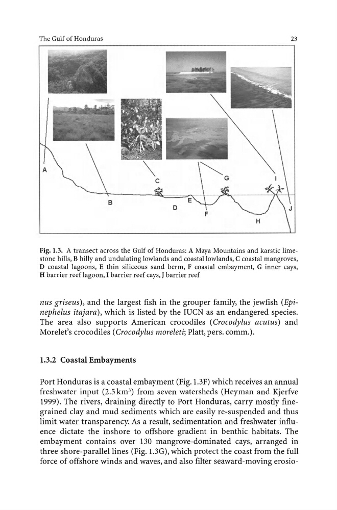
Fig. 1.3. A transect across the Gulf of Honduras: A Maya Mountains and karstic limestone hills, B hilly and undulating lowlands and coastal lowlands, C coastal mangroves,
D coastal lagoons, E thin siliceous sand berm, F coastal embayment, G inner cays,
H barrier reef lagoon, I barrier reef cays, J barrier reef
nus griseus), and the largest fish in the grouper family, the jewfish (Epinephelus itajara), which is listed by the IUCN as an endangered species.
The area also supports American crocodiles ( Crocodylus acutus) and
Morelet's crocodiles ( Crocodylus moreleti; Platt, pers. comm.).
1.3.2 Coastal Embayments
Port Honduras is a coastal embayment (Fig. 1.3F) which receives an annual
freshwater input (2.5 km 3 ) from seven watersheds (Heyman and Kjerfve
1999). The rivers, draining directly to Port Honduras, carry mostly finegrained clay and mud sediments which are easily re-suspended and thus
limit water transparency. As a result, sedimentation and freshwater influence dictate the inshore to offshore gradient in benthic habitats. The
embayment contains over 130 mangrove-dominated cays, arranged in
three shore-parallel lines (Fig. 1.3G), which protect the coast from the full
force of offshore winds and waves, and also filter seaward-moving erosio-
23
-
/~
' ..
...
·.~,f
"'~~--,~,
..
B
Fig. 1.3. A transect across the Gulf of Honduras: A Maya Mountains and karstic limestone hills, B hilly and undulating lowlands and coastal lowlands, C coastal mangroves,
D coastal lagoons, E thin siliceous sand berm, F coastal embayment, G inner cays,
H barrier reef lagoon, I barrier reef cays, J barrier reef
nus griseus), and the largest fish in the grouper family, the jewfish (Epinephelus itajara), which is listed by the IUCN as an endangered species.
The area also supports American crocodiles ( Crocodylus acutus) and
Morelet's crocodiles ( Crocodylus moreleti; Platt, pers. comm.).
1.3.2 Coastal Embayments
Port Honduras is a coastal embayment (Fig. 1.3F) which receives an annual
freshwater input (2.5 km 3 ) from seven watersheds (Heyman and Kjerfve
1999). The rivers, draining directly to Port Honduras, carry mostly finegrained clay and mud sediments which are easily re-suspended and thus
limit water transparency. As a result, sedimentation and freshwater influence dictate the inshore to offshore gradient in benthic habitats. The
embayment contains over 130 mangrove-dominated cays, arranged in
three shore-parallel lines (Fig. 1.3G), which protect the coast from the full
force of offshore winds and waves, and also filter seaward-moving erosio-