

18
W.D. Heyman and B. Kierfve
HONDURAS
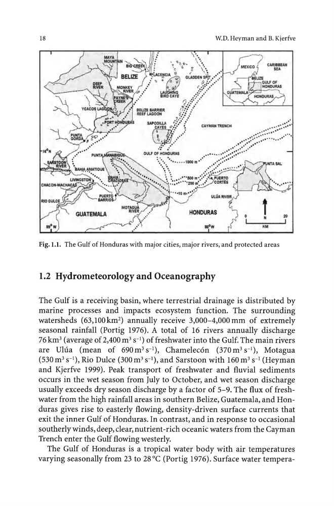
Fig. 1.1. The Gulf of Honduras with major cities, major rivers, and protected areas
1.2 Hydrometeorology and Oceanography
The Gulf is a receiving basin, where terrestrial drainage is distributed by
marine processes and impacts ecosystem function. The surrounding
watersheds (63,100km 2 ) annually receive 3,000-4,000mm of extremely
seasonal rainfall (Portig 1976). A total of 16 rivers annually discharge
76km 3 (average of2,400 m 3 s- 1 ) offreshwater into the Gulf. The main rivers
are Ulua (mean of 690m 3 s- 1 ), Chamelec6n (370m 3 s- 1 ), Motagua
(530m 3 s- 1 ), Rio Dulce (300m 3 s- 1 ), and Sarstoon with 160m 3 s- 1 (Heyman
and Kjerfve 1999). Peak transport of freshwater and fluvial sediments
occurs in the wet season from July to October, and wet season discharge
usually exceeds dry season discharge by a factor of 5-9. The flux of freshwater from the high rainfall areas in southern Belize, Guatemala, and Honduras gives rise to easterly flowing, density-driven surface currents that
exit the inner Gulf of Honduras. In contrast, and in response to occasional
southerly winds, deep, clear, nutrient-rich oceanic waters from the Cayman
Trench enter the Gulf flowing westerly.
The Gulf of Honduras is a tropical water body with air temperatures
varying seasonally from 23 to 28 °C (Portig 1976). Surface water tempera-
W.D. Heyman and B. Kierfve
HONDURAS
Fig. 1.1. The Gulf of Honduras with major cities, major rivers, and protected areas
1.2 Hydrometeorology and Oceanography
The Gulf is a receiving basin, where terrestrial drainage is distributed by
marine processes and impacts ecosystem function. The surrounding
watersheds (63,100km 2 ) annually receive 3,000-4,000mm of extremely
seasonal rainfall (Portig 1976). A total of 16 rivers annually discharge
76km 3 (average of2,400 m 3 s- 1 ) offreshwater into the Gulf. The main rivers
are Ulua (mean of 690m 3 s- 1 ), Chamelec6n (370m 3 s- 1 ), Motagua
(530m 3 s- 1 ), Rio Dulce (300m 3 s- 1 ), and Sarstoon with 160m 3 s- 1 (Heyman
and Kjerfve 1999). Peak transport of freshwater and fluvial sediments
occurs in the wet season from July to October, and wet season discharge
usually exceeds dry season discharge by a factor of 5-9. The flux of freshwater from the high rainfall areas in southern Belize, Guatemala, and Honduras gives rise to easterly flowing, density-driven surface currents that
exit the inner Gulf of Honduras. In contrast, and in response to occasional
southerly winds, deep, clear, nutrient-rich oceanic waters from the Cayman
Trench enter the Gulf flowing westerly.
The Gulf of Honduras is a tropical water body with air temperatures
varying seasonally from 23 to 28 °C (Portig 1976). Surface water tempera-