

334
2500
~0
'§.2000
~
(3
01500
...J
w
>
1ffi 1000
0::
0::
::I
(.)
500
1925
Filling of
Hoover Dam
~
1935
1945
1955
S. Alvarez-Borrego
Excess Water
Release
Filling of Glen
f----1
Canyon Dam
1965
1975
1985
1995
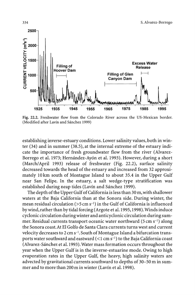
Fig. 22.2. Freshwater flow from the Colorado River across the US-Mexican border.
(Modified after Lavin and Sanchez 1999)
establishing inverse-estuary conditions. Lower salinity values, both in winter (34) and in summer (38.5), at the internal extreme of the estuary indicate the importance of fresh groundwater flow from the river (AlvarezBorrego et al. 1973; Hermi.ndez-Ay6n et al. 1993). However, during a short
(March/April 1993) release of freshwater (Fig. 22.2), surface salinity
decreased towards the head of the estuary and increased from 32 approximately 10km south of Montague Island to about 35.4 in the Upper Gulf
near San Felipe. In the estuary, a salt wedge-type stratification was
established during neap tides (Lavin and Sanchez 1999).
The depth of the Upper Gulf of California is less than 30m, with shallower
waters at the Baja California than at the Sonora side. During winter, the
mean residual circulation (>5 em s- 1 ) in the Gulf of California is influenced
by wind, rather than by tidal forcing (Argote et al. 1995, 1998). Winds induce
cyclonic circulation during winter and anticyclonic circulation during summer. Residual currents transport oceanic water northward (5 em s- 1 ) along
the Sonora coast. At El Golfo de Santa Clara currents turns west and current
velocity decreases to 2 em s- 1 • South of Montague Island a bifurcation transports water southward and eastward ( < 1 em s- 1 ) to the Baja California coast
(Alvarez-Sanchez et al.1993). Water mass formation occurs throughout the
year when the Upper Gulf is in the inverse-estuarine mode. Owing to high
evaporation rates in the Upper Gulf, the heavy, high salinity waters are
advected by gravitational currents southward to depths of 30-50 min summer and to more than 200m in winter (Lavin et al. 1998).
2500
~0
'§.2000
~
(3
01500
...J
w
>
1ffi 1000
0::
0::
::I
(.)
500
1925
Filling of
Hoover Dam
~
1935
1945
1955
S. Alvarez-Borrego
Excess Water
Release
Filling of Glen
f----1
Canyon Dam
1965
1975
1985
1995
Fig. 22.2. Freshwater flow from the Colorado River across the US-Mexican border.
(Modified after Lavin and Sanchez 1999)
establishing inverse-estuary conditions. Lower salinity values, both in winter (34) and in summer (38.5), at the internal extreme of the estuary indicate the importance of fresh groundwater flow from the river (AlvarezBorrego et al. 1973; Hermi.ndez-Ay6n et al. 1993). However, during a short
(March/April 1993) release of freshwater (Fig. 22.2), surface salinity
decreased towards the head of the estuary and increased from 32 approximately 10km south of Montague Island to about 35.4 in the Upper Gulf
near San Felipe. In the estuary, a salt wedge-type stratification was
established during neap tides (Lavin and Sanchez 1999).
The depth of the Upper Gulf of California is less than 30m, with shallower
waters at the Baja California than at the Sonora side. During winter, the
mean residual circulation (>5 em s- 1 ) in the Gulf of California is influenced
by wind, rather than by tidal forcing (Argote et al. 1995, 1998). Winds induce
cyclonic circulation during winter and anticyclonic circulation during summer. Residual currents transport oceanic water northward (5 em s- 1 ) along
the Sonora coast. At El Golfo de Santa Clara currents turns west and current
velocity decreases to 2 em s- 1 • South of Montague Island a bifurcation transports water southward and eastward ( < 1 em s- 1 ) to the Baja California coast
(Alvarez-Sanchez et al.1993). Water mass formation occurs throughout the
year when the Upper Gulf is in the inverse-estuarine mode. Owing to high
evaporation rates in the Upper Gulf, the heavy, high salinity waters are
advected by gravitational currents southward to depths of 30-50 min summer and to more than 200m in winter (Lavin et al. 1998).