

248
1800
...
. Ill 1400
""' E
:1200
I!)
:i 1000
5 800
en
s 600
400
200
e 40o
§.
~ 300
i=
<
~ 200
v
~ 100
JFMAMJJASONDJFMAMJJASON
1989
1990
>
~ 30
:::::i
~ 28
26
24
R.R. Twilley et a!.
INNER ESTUARY
J FMAMJJASONDJ
J FMAMJJASONDJ
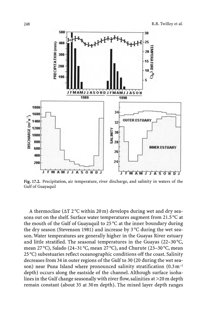
Fig. 17.2. Precipitation, air temperature, river discharge, and salinity in waters of the
Gulf of Guayaquil
A thermocline (11T 2°C within 20m) develops during wet and dry seasons out on the shelf. Surface water temperatures augment from 21.5 °C at
the mouth of the Gulf of Guayaquil to 25 oc at the inner boundary during
the dry season (Stevenson 1981) and increase by 3 oc during the wet season. Water temperatures are generally higher in the Guayas River estuary
and little stratified. The seasonal temperatures in the Guayas (22-30 °C,
mean 27°C), Salado (24-31 °C, mean 27°C), and Churute (23-30°C, mean
25 oC) subestuaries reflect oceanographic conditions off the coast. Salinity
decreases from 34 in outer regions of the Gulf to 30 (20 during the wet season) near Puna Island where pronounced salinity stratification (0.3 m- 1
depth) occurs along the eastside of the channel. Although surface isohalines in the Gulf change seasonally with river flow, salinities at >20m depth
remain constant (about 35 at 30m depth). The mixed layer depth ranges
1800
...
. Ill 1400
""' E
:1200
I!)
:i 1000
5 800
en
s 600
400
200
e 40o
§.
~ 300
i=
<
~ 200
v
~ 100
JFMAMJJASONDJFMAMJJASON
1989
1990
>
~ 30
:::::i
~ 28
26
24
R.R. Twilley et a!.
INNER ESTUARY
J FMAMJJASONDJ
J FMAMJJASONDJ
Fig. 17.2. Precipitation, air temperature, river discharge, and salinity in waters of the
Gulf of Guayaquil
A thermocline (11T 2°C within 20m) develops during wet and dry seasons out on the shelf. Surface water temperatures augment from 21.5 °C at
the mouth of the Gulf of Guayaquil to 25 oc at the inner boundary during
the dry season (Stevenson 1981) and increase by 3 oc during the wet season. Water temperatures are generally higher in the Guayas River estuary
and little stratified. The seasonal temperatures in the Guayas (22-30 °C,
mean 27°C), Salado (24-31 °C, mean 27°C), and Churute (23-30°C, mean
25 oC) subestuaries reflect oceanographic conditions off the coast. Salinity
decreases from 34 in outer regions of the Gulf to 30 (20 during the wet season) near Puna Island where pronounced salinity stratification (0.3 m- 1
depth) occurs along the eastside of the channel. Although surface isohalines in the Gulf change seasonally with river flow, salinities at >20m depth
remain constant (about 35 at 30m depth). The mixed layer depth ranges