

62
L.O. Hedin and E .D. Hetherington
Na+ as a tracer of atmospheric sources and Ca
2+
as a tracer of weathering
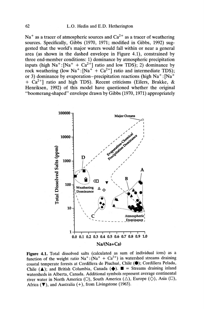
sources. Specifically, Gibbs (1970, 1971; modified in Gibbs, 1992) suggested that the world's major waters would fall within or near a general
area (as shown in the dashed envelope in Figure 4.1), constrained by
three end-member conditions: 1) dominance by atmospheric precipitation
inputs (high Na+: [Na+ + Ca
2+]
ratio and low TDS); 2) dominance by
rock weathering (low Na+: [Na+ + Ca2+] ratio and intermediate TDS);
or 3) dominance by evaporation-precipitation reactions (high Na+: [Na+
+ Ca
2+]
ratio and high TDS). Recent criticisms (Eilers, Brakke, &
Henriksen, 1992) of this model have questioned whether the original
"boomerang-shaped" envelope drawn by Gibbs (1970, 1971)appropriately
100000
10000
- S o
E-c
10
1 +--,----.-.--..-...,----r---r-r--r-,
0.0 0.1 0.2 0.3 0.4 0.5 0.6 0.7 0.8 0.9 1.0
NaI(Na+Ca)
Figure 4.1. Total dissolved salts (calculated as sum of individual ions) as a
function of the weight ratio Na+ : (Na+ + Ca
2+) in watershed streams draining
coastal temperate forests at Cordillera de Piuchue, Chile (e); Cordillera Pelada ,
Chile (.) ; and British Columbia, Canada (+). • = Streams draining inland
watersheds in Alberta, Canada. Additional symbols represent average continental
river water in North America (0), South America (t», Europe (0), Asia (0),
Africa (T), and Australia (+), from Livingstone (1963).
L.O. Hedin and E .D. Hetherington
Na+ as a tracer of atmospheric sources and Ca
2+
as a tracer of weathering
sources. Specifically, Gibbs (1970, 1971; modified in Gibbs, 1992) suggested that the world's major waters would fall within or near a general
area (as shown in the dashed envelope in Figure 4.1), constrained by
three end-member conditions: 1) dominance by atmospheric precipitation
inputs (high Na+: [Na+ + Ca
2+]
ratio and low TDS); 2) dominance by
rock weathering (low Na+: [Na+ + Ca2+] ratio and intermediate TDS);
or 3) dominance by evaporation-precipitation reactions (high Na+: [Na+
+ Ca
2+]
ratio and high TDS). Recent criticisms (Eilers, Brakke, &
Henriksen, 1992) of this model have questioned whether the original
"boomerang-shaped" envelope drawn by Gibbs (1970, 1971)appropriately
100000
10000
- S o
E-c
10
1 +--,----.-.--..-...,----r---r-r--r-,
0.0 0.1 0.2 0.3 0.4 0.5 0.6 0.7 0.8 0.9 1.0
NaI(Na+Ca)
Figure 4.1. Total dissolved salts (calculated as sum of individual ions) as a
function of the weight ratio Na+ : (Na+ + Ca
2+) in watershed streams draining
coastal temperate forests at Cordillera de Piuchue, Chile (e); Cordillera Pelada ,
Chile (.) ; and British Columbia, Canada (+). • = Streams draining inland
watersheds in Alberta, Canada. Additional symbols represent average continental
river water in North America (0), South America (t», Europe (0), Asia (0),
Africa (T), and Australia (+), from Livingstone (1963).