

14. Patch Dynamics for Forested Ecosystems in the Pacific Northwe st
285
1972
CENTRAL
CASCADE
MOUNTAINS
SCALE
==o
10 km
EJ
OREGON
1988
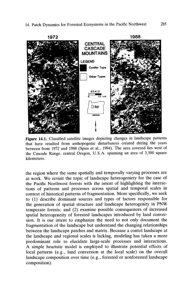
Figure 14.1. Classified satellite images depicting changes in landscape patterns
that have resulted from anthopogenic disturbances created during the years
between from 1972 and 1988 (Spies et aI., 1994). The area covered lies west of
the Cascade Range , central Oregon, U .S.A. spanning an area of 3,500 square
kilometers .
the region where the same spatially and temporally varying processes are
at work. We revisit the topic of landscape heterogeniety for the case of
the Pacific Northwest forests with the intent of highlighting the interactions of patterns and proce sses across spatial and temporal scales in
context of historical patterns of fragmentation. More specifically, we seek
to (1) describe dominant source s and types of facto rs respon sible for
the generation of spatial structure and landscape heterogenity in PNW
temperate forests; and (2) examine possible consequences of increased
spatial heterogeneity of forested landscapes introduced by land conversion . It is our intent to emphasize the need to not only document the
fragmentation of the landscape but understand the changing relationships
between the landscape patches and matrix. Because a contol landscape at
the landscape and regional scales is lacking, modeling has taken a more
predominant role to elucidate large-scale processes and interactions.
A simple heuristic model is employed to illustrate potenti al effects of
local patterns (e .g., land conversion at the local scale) on the overall
landscape composition over time (e .g., forested or nonforested landscape
composition) .
285
1972
CENTRAL
CASCADE
MOUNTAINS
SCALE
==o
10 km
EJ
OREGON
1988
Figure 14.1. Classified satellite images depicting changes in landscape patterns
that have resulted from anthopogenic disturbances created during the years
between from 1972 and 1988 (Spies et aI., 1994). The area covered lies west of
the Cascade Range , central Oregon, U .S.A. spanning an area of 3,500 square
kilometers .
the region where the same spatially and temporally varying processes are
at work. We revisit the topic of landscape heterogeniety for the case of
the Pacific Northwest forests with the intent of highlighting the interactions of patterns and proce sses across spatial and temporal scales in
context of historical patterns of fragmentation. More specifically, we seek
to (1) describe dominant source s and types of facto rs respon sible for
the generation of spatial structure and landscape heterogenity in PNW
temperate forests; and (2) examine possible consequences of increased
spatial heterogeneity of forested landscapes introduced by land conversion . It is our intent to emphasize the need to not only document the
fragmentation of the landscape but understand the changing relationships
between the landscape patches and matrix. Because a contol landscape at
the landscape and regional scales is lacking, modeling has taken a more
predominant role to elucidate large-scale processes and interactions.
A simple heuristic model is employed to illustrate potenti al effects of
local patterns (e .g., land conversion at the local scale) on the overall
landscape composition over time (e .g., forested or nonforested landscape
composition) .