

Surface Dynamics of a Coastal Area off Ancona
21
3~~/1997
\
7- \3~/1997
\
28/9r1.L,10/1997
\
13.2
13.4
13.6
13.8
Longitude
Longitude
17 -'2~8/1997
\
14~20/9/1997
,,,(hi.
\ eom
~ 12-\~.D0/1 997
' " \
Longitude
I
~
na'
132
13.4
13.6
11
Longitude
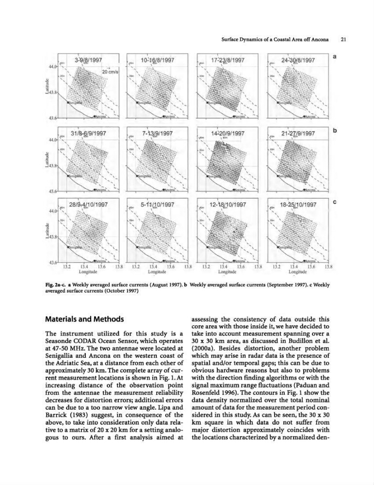
Fig. 2a-c. a Weekly averaged surface currents (August 1997). b Weekly averaged surface currents (September 1997). c Weekly
averaged surface currents (October 1997)
Materials and Methods
The instrument utilized for this study is a
Seasonde CODAR Ocean Sensor, which operates
at 47-50 MHz. The two antennae were located at
Senigallia and Ancona on the western coast of
the Adriatic Sea, at a distance from each other of
approximately 30 km. The complete array of current measurement locations is shown in Fig. 1. At
increasing distance of the observation point
from the antennae the measurement reliability
decreases for distortion errors; additional errors
can be due to a too narrow view angle. Lipa and
Barrick (1983) suggest, in consequence of the
above, to take into consideration only data relative to a matrix of 20 x 20 km for a setting analogous to ours. After a first analysis aimed at
assessing the consistency of data outside this
core area with those inside it, we have decided to
take into account measurement spanning over a
30 x 30 km area, as discussed in Budillon et al.
(2000a). Besides distortion, another problem
which may arise in radar data is the presence of
spatial andlor temporal gaps; this can be due to
obvious hardware reasons but also to problems
with the direction finding algorithms or with the
signal maximum range fluctuations (Paduan and
Rosenfeld 1996). The contours in Fig. 1 show the
data density normalized over the total nominal
amount of data for the measurement period considered in this study. As can be seen, the 30 x 30
km square in which data do not suffer from
major distortion approximately coincides with
the locations characterized by a normalized dena
b
c
21
3~~/1997
\
7- \3~/1997
\
28/9r1.L,10/1997
\
13.2
13.4
13.6
13.8
Longitude
Longitude
17 -'2~8/1997
\
14~20/9/1997
,,,(hi.
\ eom
~ 12-\~.D0/1 997
' " \
Longitude
I
~
na'
132
13.4
13.6
11
Longitude
Fig. 2a-c. a Weekly averaged surface currents (August 1997). b Weekly averaged surface currents (September 1997). c Weekly
averaged surface currents (October 1997)
Materials and Methods
The instrument utilized for this study is a
Seasonde CODAR Ocean Sensor, which operates
at 47-50 MHz. The two antennae were located at
Senigallia and Ancona on the western coast of
the Adriatic Sea, at a distance from each other of
approximately 30 km. The complete array of current measurement locations is shown in Fig. 1. At
increasing distance of the observation point
from the antennae the measurement reliability
decreases for distortion errors; additional errors
can be due to a too narrow view angle. Lipa and
Barrick (1983) suggest, in consequence of the
above, to take into consideration only data relative to a matrix of 20 x 20 km for a setting analogous to ours. After a first analysis aimed at
assessing the consistency of data outside this
core area with those inside it, we have decided to
take into account measurement spanning over a
30 x 30 km area, as discussed in Budillon et al.
(2000a). Besides distortion, another problem
which may arise in radar data is the presence of
spatial andlor temporal gaps; this can be due to
obvious hardware reasons but also to problems
with the direction finding algorithms or with the
signal maximum range fluctuations (Paduan and
Rosenfeld 1996). The contours in Fig. 1 show the
data density normalized over the total nominal
amount of data for the measurement period considered in this study. As can be seen, the 30 x 30
km square in which data do not suffer from
major distortion approximately coincides with
the locations characterized by a normalized dena
b
c