

10
G. Budillon et at.
ent biochemical water characteristics, related to
the nutrient-rich river runoff, create a spatially
complex system with a high temporal variability.
The geostrophic response to the forcing
caused by both the accumulation of less dense
water (river runoff), producing a higher sea level
in the northern part, and the forcing due to the
internal accumulation of dense waters (both
forcings sustain a southward pressure force), create a surface and a bottom current system in the
western boundary (along the Italian coast) with
both vertical and horizontal shear (Hopkins et al.
1997).
An important difference between these two
southward currents concerns the time variability
in their forcing: the former is governed by the
local change of the river runoff, while the latter
follows the winter dense-water formation.
Both these coastal currents are responsible
for the net southward export of mass and of geochemical properties.
The main goal of this paper is to highlight
the most relevant relationship between the physical and geochemical fields and to evaluate the
coastal transports of water, suspended and dissolved matter in the area offshore of Ancona as
derived by the measurements carried out during
the summer 1996 and the winter 1997 in the
frame of the PRISMA 2 project.
Materials and Methods
Field activity
The cruises took place from August to September
1996 and February-March 1997 offshore in the
Ancona area. During the summer cruises five
legs were performed measuring only instrumental data (e.g. CTD data) and two legs collecting
also geochemical samples. During FebruaryMarch cruises, thirteen legs were made and only
during one of them geochemical samples were
collected.
The spatial and temporal distributions of the
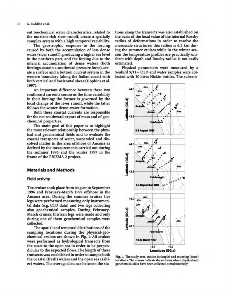
sampling locations during the physical-geochemical cruises are shown in Fig. 1. All cruises
were performed as hydrological transects from
the coast to the open sea in order to be perpendicular to the expected flows. The length of these
transects was established in order to sample both
the coastal (fresh) waters and the open sea (saltier) waters. The average distance between the stations along the transects was also established on
the basis of the local value of the internal Rossby
radius of deformations in order to resolve the
mesoscale structures; this radius is 6.5 km during the summer cruises while in the winter season the temperature promes are practically uniform with depth and Rosshy radius is not easily
estimated.
Physical parameters were measured by a
Seabird 9/11+ CTD and water samples were collected with 10 litres Niskin bottles. The subsam...
,
,
"
· -'
' ~\,
·
' .
20l0I', , .
.. ~8 "
~ .'. ' ..
":;" ~" ~ ...... ' ."
"
~ - ',~ ',
~.: ' '1-' ~
. . "
,
';;;.~-X\ · " .
. ...
1- , ' . ' •
\ . A \ " ·
,
·
· · . •
\ ...... \\
•
· ,
.. _,. /"1
,
. .1'
· ....
,, ~ ,
"
oS
,
••
.
Sl~"
... ,
~C
~
.
~ ',
'
' "
•
l ' : -" .
,
-::;.
-, . , ," "': ,-, . '
,
, ~ , ,
. .."
~ ,
, ,
1" " '- .
•
. . ,
·
- \. " " ~ " ...
. \" ' ..: .. . . .
, , .. '
... 1. ~ \~r~ ' . ,
·
'''1
' : '
,
,
.
· ....
''fOIn "
, ,
;ao;" , "' ~ \
~P ' J
~ ,
' ,"
", ~ ' :' 1,,,
,
~;i'j'~ '"
- , ·
... , ,.,,
·
! .t " '. ' ,
. . ,
\
, '.
·
,
· ·
· ·
•
,
,
·
.., \ \ .
. . ·
.. ·
. ·
12-1'-.t
• ,,,
· ; ,
13.5
14.0
.......... ' 00 .• '
Fig. 1. The study area, station (trianglt ) and mooring (cross)
locations. The arrows indicate the sections where physical and
geochemical data have been collected simultaneously
G. Budillon et at.
ent biochemical water characteristics, related to
the nutrient-rich river runoff, create a spatially
complex system with a high temporal variability.
The geostrophic response to the forcing
caused by both the accumulation of less dense
water (river runoff), producing a higher sea level
in the northern part, and the forcing due to the
internal accumulation of dense waters (both
forcings sustain a southward pressure force), create a surface and a bottom current system in the
western boundary (along the Italian coast) with
both vertical and horizontal shear (Hopkins et al.
1997).
An important difference between these two
southward currents concerns the time variability
in their forcing: the former is governed by the
local change of the river runoff, while the latter
follows the winter dense-water formation.
Both these coastal currents are responsible
for the net southward export of mass and of geochemical properties.
The main goal of this paper is to highlight
the most relevant relationship between the physical and geochemical fields and to evaluate the
coastal transports of water, suspended and dissolved matter in the area offshore of Ancona as
derived by the measurements carried out during
the summer 1996 and the winter 1997 in the
frame of the PRISMA 2 project.
Materials and Methods
Field activity
The cruises took place from August to September
1996 and February-March 1997 offshore in the
Ancona area. During the summer cruises five
legs were performed measuring only instrumental data (e.g. CTD data) and two legs collecting
also geochemical samples. During FebruaryMarch cruises, thirteen legs were made and only
during one of them geochemical samples were
collected.
The spatial and temporal distributions of the
sampling locations during the physical-geochemical cruises are shown in Fig. 1. All cruises
were performed as hydrological transects from
the coast to the open sea in order to be perpendicular to the expected flows. The length of these
transects was established in order to sample both
the coastal (fresh) waters and the open sea (saltier) waters. The average distance between the stations along the transects was also established on
the basis of the local value of the internal Rossby
radius of deformations in order to resolve the
mesoscale structures; this radius is 6.5 km during the summer cruises while in the winter season the temperature promes are practically uniform with depth and Rosshy radius is not easily
estimated.
Physical parameters were measured by a
Seabird 9/11+ CTD and water samples were collected with 10 litres Niskin bottles. The subsam...
,
,
"
· -'
' ~\,
·
' .
20l0I', , .
.. ~8 "
~ .'. ' ..
":;" ~" ~ ...... ' ."
"
~ - ',~ ',
~.: ' '1-' ~
. . "
,
';;;.~-X\ · " .
. ...
1- , ' . ' •
\ . A \ " ·
,
·
· · . •
\ ...... \\
•
· ,
.. _,. /"1
,
. .1'
· ....
,, ~ ,
"
oS
,
••
.
Sl~"
... ,
~C
~
.
~ ',
'
' "
•
l ' : -" .
,
-::;.
-, . , ," "': ,-, . '
,
, ~ , ,
. .."
~ ,
, ,
1" " '- .
•
. . ,
·
- \. " " ~ " ...
. \" ' ..: .. . . .
, , .. '
... 1. ~ \~r~ ' . ,
·
'''1
' : '
,
,
.
· ....
''fOIn "
, ,
;ao;" , "' ~ \
~P ' J
~ ,
' ,"
", ~ ' :' 1,,,
,
~;i'j'~ '"
- , ·
... , ,.,,
·
! .t " '. ' ,
. . ,
\
, '.
·
,
· ·
· ·
•
,
,
·
.., \ \ .
. . ·
.. ·
. ·
12-1'-.t
• ,,,
· ; ,
13.5
14.0
.......... ' 00 .• '
Fig. 1. The study area, station (trianglt ) and mooring (cross)
locations. The arrows indicate the sections where physical and
geochemical data have been collected simultaneously