

132
G. Brancato et al.
Materials and methods
Study Area
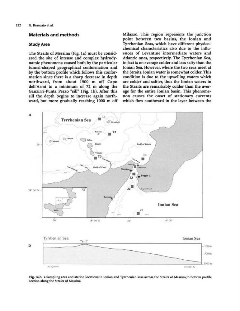
The Straits of Messina (Fig. la) must be considered the site of intense and complex hydrodynamic phenomena caused both by the particular
funnel-shaped geographical conformation and
by the bottom prome which follows this conformation since there is a sharp decrease in depth
northward, from about 1500 m off Capo
dell' Armi to a minimum of 72 m along the
Ganzirri-Punta Pezzo "sill" (Fig. Ib). After this
sill the depth begins to increase again northward, but more gradually reaching 1000 m off
a
.... , ........ -'-"
Pa' o '" • T2
., .. - ....•
o "!'",,d'
Cl.,F""'·d'
c.::::J ':Una.
30'
."". ....
38° 00'
TaormlDa
30·
Tyrrhenian
b
N<=
Milazzo. This region represents the junction
point between two basins, the Ionian and
Tyrrhenian Seas, which have different physicochemical characteristics also due to the influences of Levantine intermediate waters and
Atlantic ones, respectively. The Tyrrhenian Sea,
in fact is on average colder and less salty than the
Ionian Sea. However, where the two seas meet at
the Straits, Ionian water is somewhat colder. This
condition is due to the upwelling waters which
are colder and saltier, thus the Ionian waters in
the Straits are remarkably colder than the average for the entire Ionian basin. This phenomenon causes the onset of stationary currents
which flow southward in the layer between the
30·
Gulf of Gioi9
JI
•
Ionian Sea
16· 00'
Ionian ea
~ "o ' "
500 III
1000m
==>S
Fig.la,b. a Sampling area and station locations in Ionian and Tyrrhenian seas across the Straits of Messina; b Bottom profile
section along the Straits of Messina
G. Brancato et al.
Materials and methods
Study Area
The Straits of Messina (Fig. la) must be considered the site of intense and complex hydrodynamic phenomena caused both by the particular
funnel-shaped geographical conformation and
by the bottom prome which follows this conformation since there is a sharp decrease in depth
northward, from about 1500 m off Capo
dell' Armi to a minimum of 72 m along the
Ganzirri-Punta Pezzo "sill" (Fig. Ib). After this
sill the depth begins to increase again northward, but more gradually reaching 1000 m off
a
.... , ........ -'-"
Pa' o '" • T2
., .. - ....•
o "!'",,d'
Cl.,F""'·d'
c.::::J ':Una.
30'
."". ....
38° 00'
TaormlDa
30·
Tyrrhenian
b
N<=
Milazzo. This region represents the junction
point between two basins, the Ionian and
Tyrrhenian Seas, which have different physicochemical characteristics also due to the influences of Levantine intermediate waters and
Atlantic ones, respectively. The Tyrrhenian Sea,
in fact is on average colder and less salty than the
Ionian Sea. However, where the two seas meet at
the Straits, Ionian water is somewhat colder. This
condition is due to the upwelling waters which
are colder and saltier, thus the Ionian waters in
the Straits are remarkably colder than the average for the entire Ionian basin. This phenomenon causes the onset of stationary currents
which flow southward in the layer between the
30·
Gulf of Gioi9
JI
•
Ionian Sea
16· 00'
Ionian ea
~ "o ' "
500 III
1000m
==>S
Fig.la,b. a Sampling area and station locations in Ionian and Tyrrhenian seas across the Straits of Messina; b Bottom profile
section along the Straits of Messina