

3.5 Biofacies
37
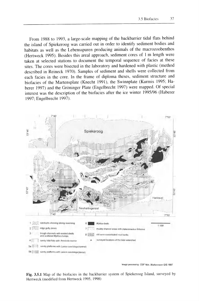
From 1988 to 1993, a large-scale mapping of the backbarrier tidal flats behind
the island of Spiekeroog was carried out in order to identify sediment bodies and
habitats as well as the Lebensspuren producing animals of the macrozoobenthos
(Hertweck 1995). Besides this areal approach, sediment cores of I m length were
taken at selected stations to document the temporal sequence of facies at these
sites. The cores were bisected in the laboratory and hardened with plastic (method
described in Reineck 1970). Samples of sediment and shells were collected from
each facies in the core. In the frame of diploma theses, sediment structure and
biofacies of the Martensplate (Knecht 1991), the Swinnplate (Kurmis 1995; Haberer 1997) and the Groninger Plate (Engelbrecht 1997) were mapped. Of special
interest was the description of the biofacies after the ice winter 1995/96 (Haberer
1997; Engelbrecht 1997).
/
I P:i: :jf. sal'ldspits soowmg s.tlong j4!lWOrking
2 ~ C
and $C3ftOfQd Myrllus d umps
4 I n :sandy !Jd::!lI'I;ot.t:s. Wlith A/{"'~ niullrl8
1 . . _- __
Spiekeroog
6_ M ;1i'u,."",
7 r muddy ch3nnol 3(03$ WIth He '&lOmasru.s fllllofml$
8 Iii.;. ?'! old SCrllt<:(1niohd .. lcd moo bilnlt$
surveyed I~hot'l$ of the tidal wa!er.;,hod
Sa .ff:=:t sandy plal20rms WIth l...lmcc COOCh,/cgJ (sparse)
5 b ~::I:ftm sandy pl3tfl)lm, WIth lanlCe COItf'JlI/eg.tJ (dense)
7"5ff
' .... ~
_ _ _ ~7"50'
1 NM
Image processing : OSF N ds. Walleruneer-GIS 1997
Fig. 3.5.1 Map of the biofacies in the backbarrier system of Spiekeroog Island, surveyed by
Hcrtwcck (modified from Hertweck 1995, 1998)
37
From 1988 to 1993, a large-scale mapping of the backbarrier tidal flats behind
the island of Spiekeroog was carried out in order to identify sediment bodies and
habitats as well as the Lebensspuren producing animals of the macrozoobenthos
(Hertweck 1995). Besides this areal approach, sediment cores of I m length were
taken at selected stations to document the temporal sequence of facies at these
sites. The cores were bisected in the laboratory and hardened with plastic (method
described in Reineck 1970). Samples of sediment and shells were collected from
each facies in the core. In the frame of diploma theses, sediment structure and
biofacies of the Martensplate (Knecht 1991), the Swinnplate (Kurmis 1995; Haberer 1997) and the Groninger Plate (Engelbrecht 1997) were mapped. Of special
interest was the description of the biofacies after the ice winter 1995/96 (Haberer
1997; Engelbrecht 1997).
/
I P:i: :jf. sal'ldspits soowmg s.tlong j4!lWOrking
2 ~ C
and $C3ftOfQd Myrllus d umps
4 I n :sandy !Jd::!lI'I;ot.t:s. Wlith A/{"'~ niullrl8
1 . . _- __
Spiekeroog
6_ M ;1i'u,."",
7 r muddy ch3nnol 3(03$ WIth He '&lOmasru.s fllllofml$
8 Iii.;. ?'! old SCrllt<:(1niohd .. lcd moo bilnlt$
surveyed I~hot'l$ of the tidal wa!er.;,hod
Sa .ff:=:t sandy plal20rms WIth l...lmcc COOCh,/cgJ (sparse)
5 b ~::I:ftm sandy pl3tfl)lm, WIth lanlCe COItf'JlI/eg.tJ (dense)
7"5ff
' .... ~
_ _ _ ~7"50'
1 NM
Image processing : OSF N ds. Walleruneer-GIS 1997
Fig. 3.5.1 Map of the biofacies in the backbarrier system of Spiekeroog Island, surveyed by
Hcrtwcck (modified from Hertweck 1995, 1998)