

402
Di Zhou
IQI Water depth (m)l /1 'Mnter current 1/-1 SUmmer current I/:;:~)I Andent delta
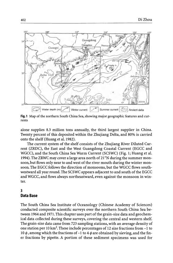
Fig.l Map of the northern South China Sea, showing major geographic features and currents
alone supplies 8.3 million tons annually, the third largest supplier in China.
Twenty percent of this deposited within the Zhujiang Delta, and 80% is carried
onto the shelf (Huang et al.I982).
The current system of the shelf consists of the Zhujiang River Diluted Current (ZRDC), the East and the West Guangdong Coastal Current (EGCC and
WGCC), and the South China Sea Warm Current (SCSWC) (Fig. 1; Huang et al.
1994). The ZRWC may cover a large area north of2l ON during the summer monsoon, but flows only near to and west of the river mouth during the winter monsoon. The EGCC follows the direction of monsoons, but the WGCC flows southwestward all year round. The SCSWC appears adjacent to and south of the EGCC
and WGCC, and flows always northeastward, even against the monsoon in winter.
3
Data Base
The South China Sea Institute of Oceanology (Chinese Academy of Sciences)
conducted composite scientific surveys over the northern South China Sea between 1964 and 1971. This chapter uses part of the grain-size data and geochemical data collected during these surveys, covering the central and western shelf.
The grain-size data came from 723 sampling stations, with an average density of
one station per 10 km 2 • These include percentages of 12 size fractions from -1 to
10 cp , among which the fractions of -1 to 4 cp are obtained by sieving, and the finer fractions by pipette. A portion of these sediment specimens was used for
Di Zhou
IQI Water depth (m)l /1 'Mnter current 1/-1 SUmmer current I/:;:~)I Andent delta
Fig.l Map of the northern South China Sea, showing major geographic features and currents
alone supplies 8.3 million tons annually, the third largest supplier in China.
Twenty percent of this deposited within the Zhujiang Delta, and 80% is carried
onto the shelf (Huang et al.I982).
The current system of the shelf consists of the Zhujiang River Diluted Current (ZRDC), the East and the West Guangdong Coastal Current (EGCC and
WGCC), and the South China Sea Warm Current (SCSWC) (Fig. 1; Huang et al.
1994). The ZRWC may cover a large area north of2l ON during the summer monsoon, but flows only near to and west of the river mouth during the winter monsoon. The EGCC follows the direction of monsoons, but the WGCC flows southwestward all year round. The SCSWC appears adjacent to and south of the EGCC
and WGCC, and flows always northeastward, even against the monsoon in winter.
3
Data Base
The South China Sea Institute of Oceanology (Chinese Academy of Sciences)
conducted composite scientific surveys over the northern South China Sea between 1964 and 1971. This chapter uses part of the grain-size data and geochemical data collected during these surveys, covering the central and western shelf.
The grain-size data came from 723 sampling stations, with an average density of
one station per 10 km 2 • These include percentages of 12 size fractions from -1 to
10 cp , among which the fractions of -1 to 4 cp are obtained by sieving, and the finer fractions by pipette. A portion of these sediment specimens was used for