

490
POLAND
100 km
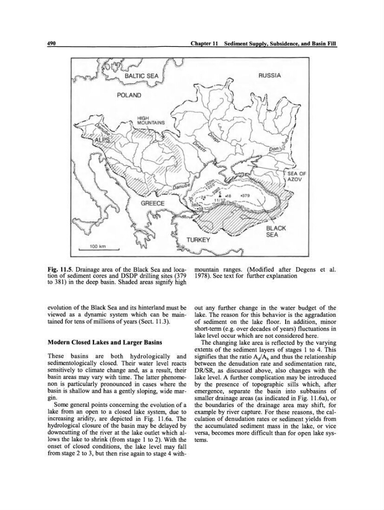
Fig. 11.5. Drainage area of the Black Sea and location of sediment cores and DSDP drilling sites (379
to 381) in the deep basin. Shaded areas signify high
evolution of the Black Sea and its hinterland must be
viewed as a dynarnic system which can be maintained for tens of millions of years (Sect. 11.3).
Modern Closed Lakes and Larger Basins
These basins are both hydrologically and
sedimentologically cJosed. Their water level reacts
sensitively to cJimate change and, as a result, their
basin areas may vary with time . The latter phenomenon is particularly pronounced in cases where the
basin is shallow and has a gently sloping, wide margin.
Some general points concerning the evolution of a
lake from an open to a cJosed lake system, due to
increasing aridity, are depicted in Fig. 11.6a. The
hydrological cJosure of the basin may be delayed by
downcutting of the river at the lake outlet which allows the lake to shrink (from stage I to 2). With the
onset of cJosed conditions, the lake level may fall
from stage 2 to 3, but then rise again to stage 4 withChapter 11 Sediment Supply, Subsidence, and Basin Fill
RUSSIA
mountain ranges. (Modified after Degens et al.
1978). See text for further explanation
out any further change in the water budget of the
lake. The reason for this behavior is the aggradation
of sediment on the lake floor. In addition, minor
short-term (e.g. over decades ofyears) fluctuations in
lake level occur wh ich are not considered here.
The changing lake area is reflected by the varying
extents of the sediment layers of stages I to 4. This
signifies that the ratio Ai Ab and thus the relationship
between the denudation rate and sedimentation rate,
DR/SR, as discussed above, also changes with the
lake level. A further complication may be introduced
by the presence of topographic sills which, after
emergence, separate the basin into subbasins of
smaller drainage areas (as indicated in Fig. 11.6a), or
the boundaries of the drainage area may shift, for
example by river capture. For these reasons, the calculation of denudation rates or sediment yields from
the accumulated sediment mass in the lake, or vi ce
versa, becomes more difficult than for open lake systems.
POLAND
100 km
Fig. 11.5. Drainage area of the Black Sea and location of sediment cores and DSDP drilling sites (379
to 381) in the deep basin. Shaded areas signify high
evolution of the Black Sea and its hinterland must be
viewed as a dynarnic system which can be maintained for tens of millions of years (Sect. 11.3).
Modern Closed Lakes and Larger Basins
These basins are both hydrologically and
sedimentologically cJosed. Their water level reacts
sensitively to cJimate change and, as a result, their
basin areas may vary with time . The latter phenomenon is particularly pronounced in cases where the
basin is shallow and has a gently sloping, wide margin.
Some general points concerning the evolution of a
lake from an open to a cJosed lake system, due to
increasing aridity, are depicted in Fig. 11.6a. The
hydrological cJosure of the basin may be delayed by
downcutting of the river at the lake outlet which allows the lake to shrink (from stage I to 2). With the
onset of cJosed conditions, the lake level may fall
from stage 2 to 3, but then rise again to stage 4 withChapter 11 Sediment Supply, Subsidence, and Basin Fill
RUSSIA
mountain ranges. (Modified after Degens et al.
1978). See text for further explanation
out any further change in the water budget of the
lake. The reason for this behavior is the aggradation
of sediment on the lake floor. In addition, minor
short-term (e.g. over decades ofyears) fluctuations in
lake level occur wh ich are not considered here.
The changing lake area is reflected by the varying
extents of the sediment layers of stages I to 4. This
signifies that the ratio Ai Ab and thus the relationship
between the denudation rate and sedimentation rate,
DR/SR, as discussed above, also changes with the
lake level. A further complication may be introduced
by the presence of topographic sills which, after
emergence, separate the basin into subbasins of
smaller drainage areas (as indicated in Fig. 11.6a), or
the boundaries of the drainage area may shift, for
example by river capture. For these reasons, the calculation of denudation rates or sediment yields from
the accumulated sediment mass in the lake, or vi ce
versa, becomes more difficult than for open lake systems.