

3.2 Tidal Flats
111
-------- I
7
...,..----...
/ .
--- ~ -I
----;:---,.'
a
b
I-----:~~'
I
----.,:
1-- --,/
I
\ ... _..1 :
\
,.
WASHOVER
Al
FAN
I
I
I
---':
\
'';: ..
\
) ".; ..
SM ALL
' ~ARROW
FLOODf> -.,:(" INLET
TIDAL- t J ' -.::
'--/ .
DEL TA
·: · BARRIER
"
, ~
,'" r- "TI
, ~
,C"
1----",«1'
DEEP ~\
PATH OF
\.J TIDAL WAVE
~ ISLAND
') ~S
(I ~
SE"
,
------ '
... LOW TlDES
HIGH
WAVE-DOMINATED
,
c
.... ~: ':.: _
EBB.. ~ .!.-.:
TlDAL
• I:"' "
DEL TA
BARRIER
ISLAND
":', .' .. : '
d
S km
--<
.. ..
S km : .' .. '. :.':.
............. .'.', . : .. .' '
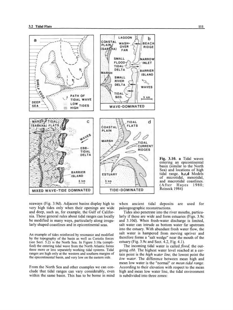
Fig. 3.10. a Tidal waves
entering an epicontinental
basin (sirnilar to the North
Sea) and locations of high
tidal range. b,c,d Models
of microtidal, mesotidal,
and macrotidal coastlines.
(After Hayes 1980;
Reineck 1984)
MIXED WAVE-TIDE DOMINA TED
TIDE-DOMINATED
seaways (Fig. 3.9d). Adjacent basins display high to
very high tides only when their openings are wide
and deep, such as, for example, the Gulf of California. These general rules about tidal ranges can locally
be modified in many ways, particularly along irregularly shaped coastlines and in epicontinental seas.
An example of tides reinforeed by resonanee and modified
by the topography of the basin as weil as Coriolis fore es
(see Seet. 5.2) is the North Sea. In Figure 3.lOa (simplified) the entering tidal wave from the North Atlantic forms
three more or less separately working tidal systems. Tidal
ranges are high only at the western and southern margins of
the epieontinental basin, and very low on the eastern side.
From the North Sea and other examples we can conc1ude that tidal ranges can vary considerably, even
within the same basin. This has to be borne in mi nd
when ancient tidal deposits are used for
paleogeographic reconstructions.
Tides also penetrate into the river mouths, particularly if these are wide and form estuaries (Figs. 3.9c
and 3.1 Od). When fresh-water discharge is limited,
salt water can intrude as bottom water far upstream
into the estuary. With abundant fresh water flow, the
salt water is hampered from moving upriver and
therefore forms a "salt wedge" near the mouth of the
estuary (Fig. 3.9c and Sect. 4.2, Fig. 4.1).
The incoming tidal water is called flood, the outgoing ebb. The highest water level reached at a certain point is the high water fine, the lowest point the
low water. The difference between mean high and
mean low water is the "normal" or mean tidal range.
According to their elevation with respect to the mean
high and mean low water line, the tidal environment
is subdivided into three zones:
111
-------- I
7
...,..----...
/ .
--- ~ -I
----;:---,.'
a
b
I-----:~~'
I
----.,:
1-- --,/
I
\ ... _..1 :
\
,.
WASHOVER
Al
FAN
I
I
I
---':
\
'';: ..
\
) ".; ..
SM ALL
' ~ARROW
FLOODf> -.,:(" INLET
TIDAL- t J ' -.::
'--/ .
DEL TA
·: · BARRIER
"
, ~
,'" r- "TI
, ~
,C"
1----",«1'
DEEP ~\
PATH OF
\.J TIDAL WAVE
~ ISLAND
') ~S
(I ~
SE"
,
------ '
... LOW TlDES
HIGH
WAVE-DOMINATED
,
c
.... ~: ':.: _
EBB.. ~ .!.-.:
TlDAL
• I:"' "
DEL TA
BARRIER
ISLAND
":', .' .. : '
d
S km
--<
.. ..
S km : .' .. '. :.':.
............. .'.', . : .. .' '
Fig. 3.10. a Tidal waves
entering an epicontinental
basin (sirnilar to the North
Sea) and locations of high
tidal range. b,c,d Models
of microtidal, mesotidal,
and macrotidal coastlines.
(After Hayes 1980;
Reineck 1984)
MIXED WAVE-TIDE DOMINA TED
TIDE-DOMINATED
seaways (Fig. 3.9d). Adjacent basins display high to
very high tides only when their openings are wide
and deep, such as, for example, the Gulf of California. These general rules about tidal ranges can locally
be modified in many ways, particularly along irregularly shaped coastlines and in epicontinental seas.
An example of tides reinforeed by resonanee and modified
by the topography of the basin as weil as Coriolis fore es
(see Seet. 5.2) is the North Sea. In Figure 3.lOa (simplified) the entering tidal wave from the North Atlantic forms
three more or less separately working tidal systems. Tidal
ranges are high only at the western and southern margins of
the epieontinental basin, and very low on the eastern side.
From the North Sea and other examples we can conc1ude that tidal ranges can vary considerably, even
within the same basin. This has to be borne in mi nd
when ancient tidal deposits are used for
paleogeographic reconstructions.
Tides also penetrate into the river mouths, particularly if these are wide and form estuaries (Figs. 3.9c
and 3.1 Od). When fresh-water discharge is limited,
salt water can intrude as bottom water far upstream
into the estuary. With abundant fresh water flow, the
salt water is hampered from moving upriver and
therefore forms a "salt wedge" near the mouth of the
estuary (Fig. 3.9c and Sect. 4.2, Fig. 4.1).
The incoming tidal water is called flood, the outgoing ebb. The highest water level reached at a certain point is the high water fine, the lowest point the
low water. The difference between mean high and
mean low water is the "normal" or mean tidal range.
According to their elevation with respect to the mean
high and mean low water line, the tidal environment
is subdivided into three zones: