

6 Building Bridges to Science: Making Coastal Science Better Understood
Choesil8ank and Flet't I"fatu
Rosc"",
DORSET
61
WAREHAM .
l:::===::l',Okm
t
THE ENGLISH CHANNEL
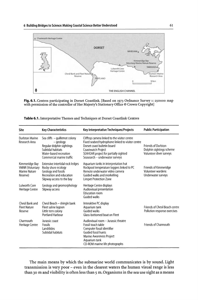
Fig. 6.1 . Centres participating in Dorset Coastlink. [Based on 1973 Ordnance Survey 1: 250000 map
with permission of the controller of Her Majesty's Stationary Office © Crown Copyright]
Table 6.1. Interpretative Themes and Techniques at Dorset Coastlink Centres
Site
Key Characteristics
Key Interpretative Techniques/Projects
Public Participation
Durlston Marine Sea cliffs - guillemot colony
Clifftop camera linked to the visitor centre
Research Area
- geology
Fixed seabed hydrophone linked to visitor centre
Regular dolphin sightings
Dorset coast bulletin board
Friends of Durlston
Subtidal habitats
Coastwatch Project
Dolphin sightings scheme
Water-based recreation
SEAHEAR project for partially sighted
Volunteer diver surveys
Commercial marine traffic
Seasearch - underwater surveys
Kimmeridge Bay Extensive intertidal rock ledges Aquarium tanks in interpretation hut
VMNR (Voluntary Rocky shore ecology
Rockpool temperature loggers linked to PC
Friends of Kimmeridge
Marine Nature
Geology and fossils
Remote underwater video camera
Volunteer wardens
Reserve)
Recreation and education
Guided walks and snorkelling
Underwater surveys
Slipway access to the bay
Limpet Protection Zone
Lulworth Core
Geology and geomorphology
Heritage Centre displays
Heritage Centre Slipwayaccess
Audiovisual presentation
Education room
Guided walks
Chesil Bank and Chesil Beach - shingle bank
Interaktive PC display
Fleet Nature
Fleet saline lagoon
Aquarium tank
Friends of Chesil Beach centrE
Reserve
Little tern colony
Guided walks
Pollution response exercises
Portland Harbour
Glass-bottomed boat on Fleet
Charmouth
Jurassic coast
Audiovisual room - Jurassic theatre
Heritage Centre Fossils
Fossil touch table
Friends of Charmouth
Landslides
Computer fossil identifier
Subtidal habitats
Guided fossil hunts
Marine Awareness Project
Aquarium tank
CD-ROM marine life photographs
The main means by which the submarine world communicates is by sound. Light
transmission is very poor - even in the clearest waters the human visual range is less
than 30 m and visibility is often less than 5 m. Organisms in the sea use sight as a means
Choesil8ank and Flet't I"fatu
Rosc"",
DORSET
61
WAREHAM .
l:::===::l',Okm
t
THE ENGLISH CHANNEL
Fig. 6.1 . Centres participating in Dorset Coastlink. [Based on 1973 Ordnance Survey 1: 250000 map
with permission of the controller of Her Majesty's Stationary Office © Crown Copyright]
Table 6.1. Interpretative Themes and Techniques at Dorset Coastlink Centres
Site
Key Characteristics
Key Interpretative Techniques/Projects
Public Participation
Durlston Marine Sea cliffs - guillemot colony
Clifftop camera linked to the visitor centre
Research Area
- geology
Fixed seabed hydrophone linked to visitor centre
Regular dolphin sightings
Dorset coast bulletin board
Friends of Durlston
Subtidal habitats
Coastwatch Project
Dolphin sightings scheme
Water-based recreation
SEAHEAR project for partially sighted
Volunteer diver surveys
Commercial marine traffic
Seasearch - underwater surveys
Kimmeridge Bay Extensive intertidal rock ledges Aquarium tanks in interpretation hut
VMNR (Voluntary Rocky shore ecology
Rockpool temperature loggers linked to PC
Friends of Kimmeridge
Marine Nature
Geology and fossils
Remote underwater video camera
Volunteer wardens
Reserve)
Recreation and education
Guided walks and snorkelling
Underwater surveys
Slipway access to the bay
Limpet Protection Zone
Lulworth Core
Geology and geomorphology
Heritage Centre displays
Heritage Centre Slipwayaccess
Audiovisual presentation
Education room
Guided walks
Chesil Bank and Chesil Beach - shingle bank
Interaktive PC display
Fleet Nature
Fleet saline lagoon
Aquarium tank
Friends of Chesil Beach centrE
Reserve
Little tern colony
Guided walks
Pollution response exercises
Portland Harbour
Glass-bottomed boat on Fleet
Charmouth
Jurassic coast
Audiovisual room - Jurassic theatre
Heritage Centre Fossils
Fossil touch table
Friends of Charmouth
Landslides
Computer fossil identifier
Subtidal habitats
Guided fossil hunts
Marine Awareness Project
Aquarium tank
CD-ROM marine life photographs
The main means by which the submarine world communicates is by sound. Light
transmission is very poor - even in the clearest waters the human visual range is less
than 30 m and visibility is often less than 5 m. Organisms in the sea use sight as a means