

172
"-!nlerniJlional Boundary
1 - - - Sunderhan
- - Sub-Division
"
IllIlJ Afforestation
[SSJ Reserve Forest
•
Growlh Centre
0 ,
NORTH
10
20
,
!
24- PARGANAS
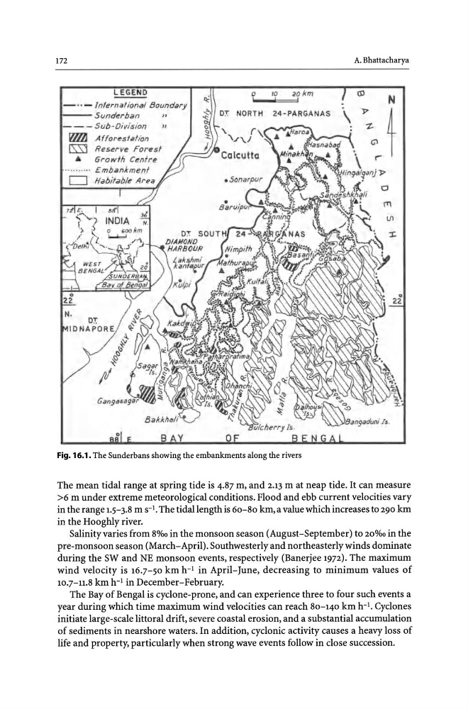
Fig. 16.1. The Sunderbans showing the embankments along the rivers
A. Bhattacharya
(J)
N
\
J>
t
"ZG"l
f""
The mean tidal range at spring tide is 4.87 m, and 2.13 m at neap tide. It can measure
>6 m under extreme meteorological conditions. Flood and ebb current velocities vary
in the range 1.5-3.8 m S-I. The tidal length is 60-80 km, a value which increases to 290 km
in the Hoogbly river.
Salinity varies from 8%0 in the monsoon season (August-September) to 20%0 in the
pre-monsoon season (March-April). Southwesterly and northeasterly winds dominate
during the SW and NE monsoon events, respectively (Banerjee 1972). The maximum
wind velocity is 16.7-50 km h-I in April-June, decreasing to minimum values of
10.7-11.8 km h- I in December-February.
The Bay of Bengal is cyclone-prone, and can experience three to four such events a
year during which time maximum wind velocities can reach 80-140 km h-I. Cyclones
initiate large-scale littoral drift, severe coastal erosion, and a substantial accumulation
of sediments in nearshore waters. In addition, cyclonic activity causes a heavy loss of
life and property, particularly when strong wave events follow in close succession.
"-!nlerniJlional Boundary
1 - - - Sunderhan
- - Sub-Division
"
IllIlJ Afforestation
[SSJ Reserve Forest
•
Growlh Centre
0 ,
NORTH
10
20
,
!
24- PARGANAS
Fig. 16.1. The Sunderbans showing the embankments along the rivers
A. Bhattacharya
(J)
N
\
J>
t
"ZG"l
f""
The mean tidal range at spring tide is 4.87 m, and 2.13 m at neap tide. It can measure
>6 m under extreme meteorological conditions. Flood and ebb current velocities vary
in the range 1.5-3.8 m S-I. The tidal length is 60-80 km, a value which increases to 290 km
in the Hoogbly river.
Salinity varies from 8%0 in the monsoon season (August-September) to 20%0 in the
pre-monsoon season (March-April). Southwesterly and northeasterly winds dominate
during the SW and NE monsoon events, respectively (Banerjee 1972). The maximum
wind velocity is 16.7-50 km h-I in April-June, decreasing to minimum values of
10.7-11.8 km h- I in December-February.
The Bay of Bengal is cyclone-prone, and can experience three to four such events a
year during which time maximum wind velocities can reach 80-140 km h-I. Cyclones
initiate large-scale littoral drift, severe coastal erosion, and a substantial accumulation
of sediments in nearshore waters. In addition, cyclonic activity causes a heavy loss of
life and property, particularly when strong wave events follow in close succession.