

214
Print. Alben
C. BERTOIA, J. FALKINGHAM, F. FETTERER
SAR Data Flow
in the
Canadian Ice Service
Dash·7
SAR
~ Inmarsa.
~ (Communications)
~
(/
CCG lcebreak ....
,.~:··t]~] ~-.=
Marine RadiQ Stations
LandU",rs
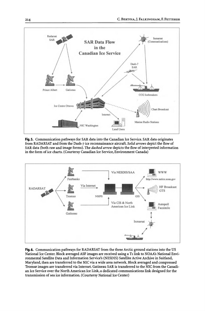
Fig.5. Communication pathways for SAR data into the Canadian Ice Service. SAR data originates
from RADARSAT and from the Dash-7 ice reconnaissance aircraft. Solid arrows depict the flow of
SAR data (both raw and image forms). The dashed arrow depicts the flow of interpreted information
in the form of ice charts. (Courtersy Canadian Ice Service, Environment Canada)
Fairbanks
Galineau
1
Vi. NESDISISAA
WWW
L. '::;~:,:,
~
Vialnlemel •
NS IPS
______ --' J Vi. CIS & Nonh
American Ice Link
hun"""'l
t
AULOPOU
Facsimile
Fig. 6. Communication pathways for RADARSAT from the three Arctic ground stations into the US
National Ice Center. Block averaged ASF images are received using a Tllink to NOAA's National Environmental Satellite Data and Information Service's (NESDIS) Satellite Active Archive in Suitland,
Maryland, then are transferred to the NIC via a wide area network. Block averaged and compressed
TromS0 images are transferred via Internet. Gatineau SAR is transferred to the NIC from the Canadian Ice Service over the North American Ice Link, a dedicated communications link designed for the
transmission of sea ice information. (Courtersy National Ice Center)
Print. Alben
C. BERTOIA, J. FALKINGHAM, F. FETTERER
SAR Data Flow
in the
Canadian Ice Service
Dash·7
SAR
~ Inmarsa.
~ (Communications)
~
(/
CCG lcebreak ....
,.~:··t]~] ~-.=
Marine RadiQ Stations
LandU",rs
Fig.5. Communication pathways for SAR data into the Canadian Ice Service. SAR data originates
from RADARSAT and from the Dash-7 ice reconnaissance aircraft. Solid arrows depict the flow of
SAR data (both raw and image forms). The dashed arrow depicts the flow of interpreted information
in the form of ice charts. (Courtersy Canadian Ice Service, Environment Canada)
Fairbanks
Galineau
1
Vi. NESDISISAA
WWW
L. '::;~:,:,
~
Vialnlemel •
NS IPS
______ --' J Vi. CIS & Nonh
American Ice Link
hun"""'l
t
AULOPOU
Facsimile
Fig. 6. Communication pathways for RADARSAT from the three Arctic ground stations into the US
National Ice Center. Block averaged ASF images are received using a Tllink to NOAA's National Environmental Satellite Data and Information Service's (NESDIS) Satellite Active Archive in Suitland,
Maryland, then are transferred to the NIC via a wide area network. Block averaged and compressed
TromS0 images are transferred via Internet. Gatineau SAR is transferred to the NIC from the Canadian Ice Service over the North American Ice Link, a dedicated communications link designed for the
transmission of sea ice information. (Courtersy National Ice Center)