

9 Alaska SAR Facility: The US Science Center for Sea Ice SAR Data
9.1.2
Capabilities
191
The overall total of ASF capability is extensive and complex. Briefly, ASF is equipped to
plan data acquisitions, request data acquisitions from the agencies flying the SAR satellites, receive and record downloaded data from these satellites as they pass through the
receiving masks, process the data stream into calibrated SAR images, and distribute these
images to users. In the area of data reception, ASF has been built to track and acquire Sband and X-band downlinks from polar-orbiting satellites having the high (ca. 100 million bits per second) data rates characteristic of the SAR satellites. In data processing ASF
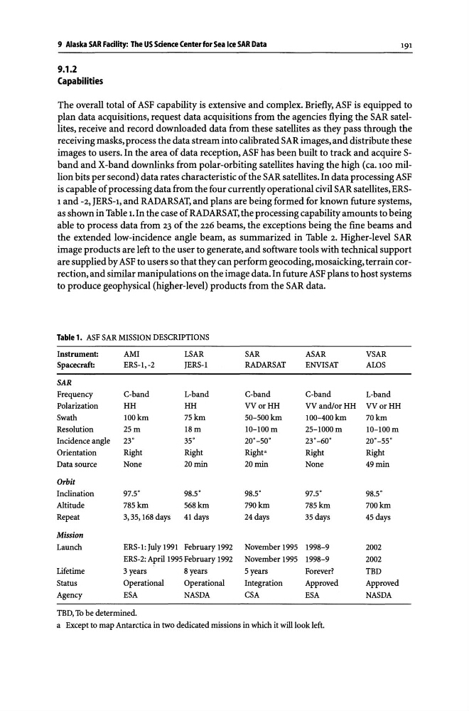
is capable of processing data from the four currently operational civil SAR satellites, ERS1 and -2, JERS-1, and RADARSAT, and plans are being formed for known future systems,
as shown in Table 1. In the case of RADARSAT, the processing capability amounts to being
able to process data from 23 of the 226 beams, the exceptions being the fine beams and
the extended low-incidence angle beam, as summarized in Table 2. Higher-level SAR
image products are left to the user to generate, and software tools with technical support
are supplied by ASF to users so that they can perform geocoding, mosaicking, terrain correction, and similar manipulations on the image data. In future ASF plans to host systems
to produce geophysical (higher-level) products from the SAR data.
Table 1. ASF SAR MISSION DESCRIPTIONS
Instrument:
AMI
LSAR
SAR
ASAR
VSAR
Spacecraft:
ERS-l,-2
JERS-l
RADARSAT
ENVISAT
ALOS
SAR
Frequency
C-band
L-band
C-band
C-band
L-band
Polarization
HH
HH
VV or HH
VVandlorHH VVorHH
Swath
100km
75km
50-500km
100-400km
70km
Resolution
25m
18m
10-100 m
25-1000m
1O-100m
Incidence angle
23 0
35 0
20 0 _50 0
23 0 _60 0
20 0 _55 0
Orientation
Right
Right
Right'
Right
Right
Data source
None
20 min
20 min
None
49 min
Orbit
Inclination
97S
98S
98S
97S
98S
Altitude
785km
568km
790km
785km
700km
Repeat
3,35,168 days
41 days
24 days
35 days
45 days
Mission
Launch
ERS-l: July 1991 February 1992
November 1995 1998-9
2002
ERS-2: April 1995 February 1992
November 1995 1998-9
2002
Lifetime
3 years
8 years
5 years
Forever?
TBD
Status
Operational
Operational
Integration
Approved
Approved
Agency
ESA
NASDA
CSA
ESA
NASDA
TBD, To be determined.
a Except to map Antarctica in two dedicated missions in whim it will look left.
9.1.2
Capabilities
191
The overall total of ASF capability is extensive and complex. Briefly, ASF is equipped to
plan data acquisitions, request data acquisitions from the agencies flying the SAR satellites, receive and record downloaded data from these satellites as they pass through the
receiving masks, process the data stream into calibrated SAR images, and distribute these
images to users. In the area of data reception, ASF has been built to track and acquire Sband and X-band downlinks from polar-orbiting satellites having the high (ca. 100 million bits per second) data rates characteristic of the SAR satellites. In data processing ASF
is capable of processing data from the four currently operational civil SAR satellites, ERS1 and -2, JERS-1, and RADARSAT, and plans are being formed for known future systems,
as shown in Table 1. In the case of RADARSAT, the processing capability amounts to being
able to process data from 23 of the 226 beams, the exceptions being the fine beams and
the extended low-incidence angle beam, as summarized in Table 2. Higher-level SAR
image products are left to the user to generate, and software tools with technical support
are supplied by ASF to users so that they can perform geocoding, mosaicking, terrain correction, and similar manipulations on the image data. In future ASF plans to host systems
to produce geophysical (higher-level) products from the SAR data.
Table 1. ASF SAR MISSION DESCRIPTIONS
Instrument:
AMI
LSAR
SAR
ASAR
VSAR
Spacecraft:
ERS-l,-2
JERS-l
RADARSAT
ENVISAT
ALOS
SAR
Frequency
C-band
L-band
C-band
C-band
L-band
Polarization
HH
HH
VV or HH
VVandlorHH VVorHH
Swath
100km
75km
50-500km
100-400km
70km
Resolution
25m
18m
10-100 m
25-1000m
1O-100m
Incidence angle
23 0
35 0
20 0 _50 0
23 0 _60 0
20 0 _55 0
Orientation
Right
Right
Right'
Right
Right
Data source
None
20 min
20 min
None
49 min
Orbit
Inclination
97S
98S
98S
97S
98S
Altitude
785km
568km
790km
785km
700km
Repeat
3,35,168 days
41 days
24 days
35 days
45 days
Mission
Launch
ERS-l: July 1991 February 1992
November 1995 1998-9
2002
ERS-2: April 1995 February 1992
November 1995 1998-9
2002
Lifetime
3 years
8 years
5 years
Forever?
TBD
Status
Operational
Operational
Integration
Approved
Approved
Agency
ESA
NASDA
CSA
ESA
NASDA
TBD, To be determined.
a Except to map Antarctica in two dedicated missions in whim it will look left.