

178
IAN ROBINSON
AVHRR with its less certain radiometric accuracy, although its wide swath
and more frequent revisits can still not view the sea when cloud is present.
This problem can be partly overcome in Equatorial regions by the use of
geostationary sensors, which are available at all times of the day and night to
see the sea whenever there are gaps in the cloud. Ultimately, however, the
absence of IR observations caused by persistent cloud can be overcome only
by the use of microwave sensors. Although their spatial resolution is very
much inferior to that of infrared sensors, the recent improvement in their
radiometric performance should enable them to contribute unique
information to operational systems under persistently cloudy conditions.
Sensor name
Product name and
resolution
Spatial coverage in
specified time
Type of
SST
Data provider
AATSR
ATS_NR_2P
1km
Global, pseudo 3 day
repeat
Skin
ESA
AATSR
ATS-Meteo
10 arc min
Global, pseudo 3 day
repeat
Skin
ESA
AVHRR
NOAA16
GAC (1)
9km
Global, daily repeat
At 1m
(2)
NAVOCEANO
AVHRR
NOAA16
LAC (3)
2 km
Regional, at least daily
repeat, day and night
At 1m
(2)
NAVOCEANO
AVHRR
NOAA16
NAR
2 km
Regional, at least daily
repeat, day and night
Subskin EUMESAT
O&SI SAF
AVHRR
NOAA17
GAC (1)
9km
Global, daily repeat
At 1m
(2)
NAVOCEANO
AVHRR
NOAA17
LAC (3)
2 km
Regional, at least daily
repeat, day and night
At 1m
(2)
NAVOCEANO
AVHRR
NOAA17
NAR
2 km
Regional, at least daily
repeat, day and night
Subskin EUMESAT
O&SI SAF
MSG SEVIRI SEVIRI
0.1º lat./lon.
Regional, 3 hour repeat
Subskin EUMETSAT
O&SI SAF
GOES-East
GOES
4 km
Regional, 3 hour repeat
At 1m
(2)
EUMETSAT
O&SI SAF
GOES-East
GOES
6 km
Regional, 1/2 hour repeat
At 1m
(2)
NAVOCEANO,
PO.DAAC
TMI
0.25º lat./lon. grid 40ºN - 40ºS, daily
Subskin REMSS
AMSR-E
0.25º lat./lon. grid Global, daily repeat
Subskin REMSS
1. GAC means the SST product is produced from the global area coverage, a reduced dataset
stored on board and delivered once per orbit.
2. This expresses the definition of the product given by the data provider.
3. LAC means the SST product is produced from the local area coverage, which is the full
resolution data stream downloaded on acquisition to a ground station within line of sight
of the satellite. LAC is not available globally, but there is good provision of receiving
stations to cover European coastal and shelf waters and much of the North Atlantic Ocean.
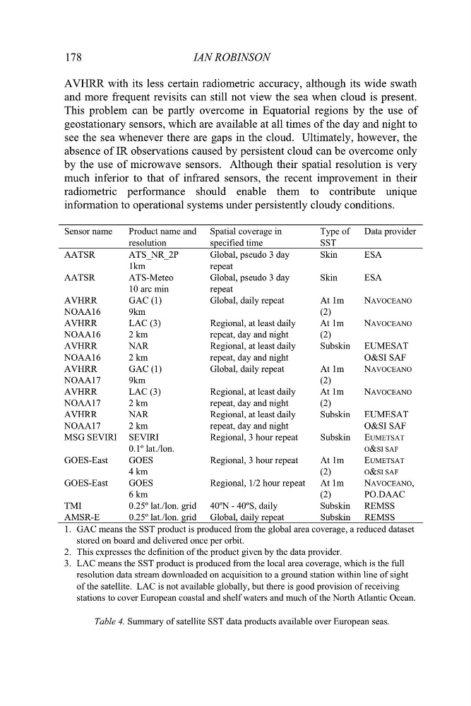
Table 4. Summary of satellite SST data products available over European seas.
IAN ROBINSON
AVHRR with its less certain radiometric accuracy, although its wide swath
and more frequent revisits can still not view the sea when cloud is present.
This problem can be partly overcome in Equatorial regions by the use of
geostationary sensors, which are available at all times of the day and night to
see the sea whenever there are gaps in the cloud. Ultimately, however, the
absence of IR observations caused by persistent cloud can be overcome only
by the use of microwave sensors. Although their spatial resolution is very
much inferior to that of infrared sensors, the recent improvement in their
radiometric performance should enable them to contribute unique
information to operational systems under persistently cloudy conditions.
Sensor name
Product name and
resolution
Spatial coverage in
specified time
Type of
SST
Data provider
AATSR
ATS_NR_2P
1km
Global, pseudo 3 day
repeat
Skin
ESA
AATSR
ATS-Meteo
10 arc min
Global, pseudo 3 day
repeat
Skin
ESA
AVHRR
NOAA16
GAC (1)
9km
Global, daily repeat
At 1m
(2)
NAVOCEANO
AVHRR
NOAA16
LAC (3)
2 km
Regional, at least daily
repeat, day and night
At 1m
(2)
NAVOCEANO
AVHRR
NOAA16
NAR
2 km
Regional, at least daily
repeat, day and night
Subskin EUMESAT
O&SI SAF
AVHRR
NOAA17
GAC (1)
9km
Global, daily repeat
At 1m
(2)
NAVOCEANO
AVHRR
NOAA17
LAC (3)
2 km
Regional, at least daily
repeat, day and night
At 1m
(2)
NAVOCEANO
AVHRR
NOAA17
NAR
2 km
Regional, at least daily
repeat, day and night
Subskin EUMESAT
O&SI SAF
MSG SEVIRI SEVIRI
0.1º lat./lon.
Regional, 3 hour repeat
Subskin EUMETSAT
O&SI SAF
GOES-East
GOES
4 km
Regional, 3 hour repeat
At 1m
(2)
EUMETSAT
O&SI SAF
GOES-East
GOES
6 km
Regional, 1/2 hour repeat
At 1m
(2)
NAVOCEANO,
PO.DAAC
TMI
0.25º lat./lon. grid 40ºN - 40ºS, daily
Subskin REMSS
AMSR-E
0.25º lat./lon. grid Global, daily repeat
Subskin REMSS
1. GAC means the SST product is produced from the global area coverage, a reduced dataset
stored on board and delivered once per orbit.
2. This expresses the definition of the product given by the data provider.
3. LAC means the SST product is produced from the local area coverage, which is the full
resolution data stream downloaded on acquisition to a ground station within line of sight
of the satellite. LAC is not available globally, but there is good provision of receiving
stations to cover European coastal and shelf waters and much of the North Atlantic Ocean.
Table 4. Summary of satellite SST data products available over European seas.