

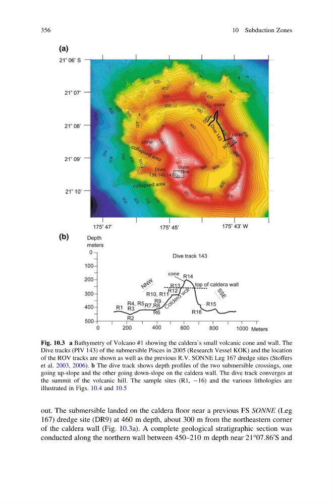
out. The submersible landed on the caldera floor near a previous FS SONNE (Leg
167) dredge site (DR9) at 460 m depth, about 300 m from the northeastern corner
of the caldera wall (Fig. 10.3a). A complete geological stratigraphic section was
conducted along the northern wall between 450–210 m depth near 21°07.86
0 S and
Fig. 10.3 a Bathymetry of Volcano #1 showing the caldera’s small volcanic cone and wall. The
Dive tracks (PIV 143) of the submersible Pisces in 2005 (Research Vessel KOK) and the location
of the ROV tracks are shown as well as the previous R.V. SONNE Leg 167 dredge sites (Stoffers
et al. 2003, 2006). b The dive track shows depth profiles of the two submersible crossings, one
going up-slope and the other going down-slope on the caldera wall. The dive track converges at
the summit of the volcanic hill. The sample sites (R1, -16) and the various lithologies are
illustrated in Figs. 10.4 and 10.5
356
10 Subduction Zones
167) dredge site (DR9) at 460 m depth, about 300 m from the northeastern corner
of the caldera wall (Fig. 10.3a). A complete geological stratigraphic section was
conducted along the northern wall between 450–210 m depth near 21°07.86
0 S and
Fig. 10.3 a Bathymetry of Volcano #1 showing the caldera’s small volcanic cone and wall. The
Dive tracks (PIV 143) of the submersible Pisces in 2005 (Research Vessel KOK) and the location
of the ROV tracks are shown as well as the previous R.V. SONNE Leg 167 dredge sites (Stoffers
et al. 2003, 2006). b The dive track shows depth profiles of the two submersible crossings, one
going up-slope and the other going down-slope on the caldera wall. The dive track converges at
the summit of the volcanic hill. The sample sites (R1, -16) and the various lithologies are
illustrated in Figs. 10.4 and 10.5
356
10 Subduction Zones