

trench and is sinking at a rate of about 160 mm/year. The overall region is considered as being an area of intense volcanic and seismic activity. However,
because the Tonga-Kermadec area is mostly uninhabited, it has received very little
attention. Although several US and French expeditions have worked on the backarc basins of the Tonga-Kermadec Island arc in the past, very little is known about
the arc itself. Scientists have investigated the southern portion of the TongaKermadec Ridge only after the 1990s (Wright 1994; Wright et al.1996; de Ronde
et al. 2005; Stoffers et al. 2006). The Tonga-Kermadec Trench borders the TongaKermadec volcanic arc to the east, and is bordered by the Havre trough and the
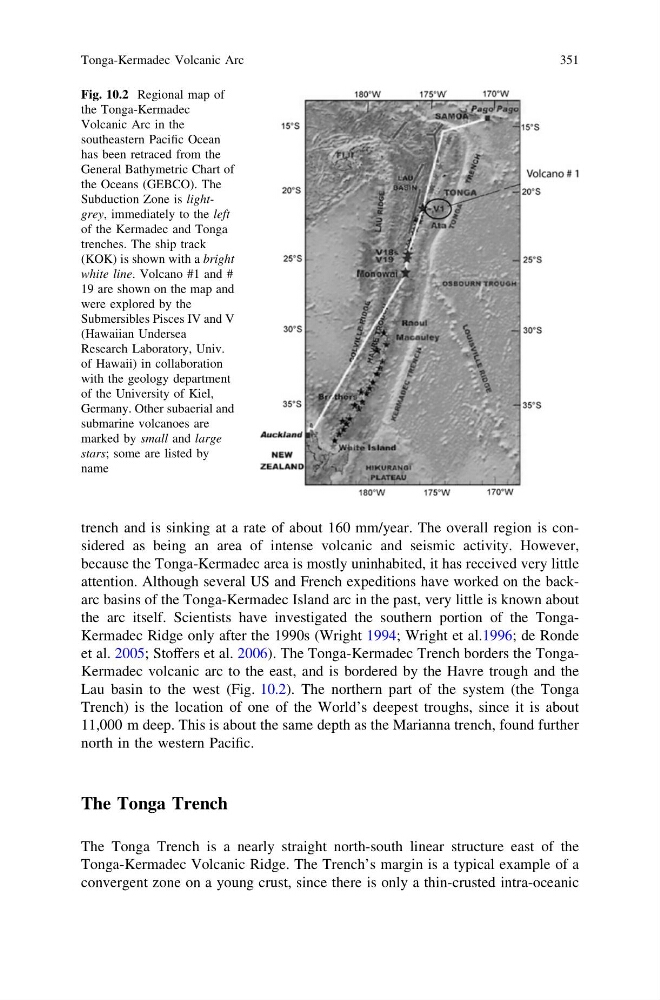
Lau basin to the west (Fig. 10.2). The northern part of the system (the Tonga
Trench) is the location of one of the World’s deepest troughs, since it is about
11,000 m deep. This is about the same depth as the Marianna trench, found further
north in the western Pacific.
The Tonga Trench
The Tonga Trench is a nearly straight north-south linear structure east of the
Tonga-Kermadec Volcanic Ridge. The Trench’s margin is a typical example of a
convergent zone on a young crust, since there is only a thin-crusted intra-oceanic
Fig. 10.2 Regional map of
the Tonga-Kermadec
Volcanic Arc in the
southeastern Pacific Ocean
has been retraced from the
General Bathymetric Chart of
the Oceans (GEBCO). The
Subduction Zone is lightgrey, immediately to the left
of the Kermadec and Tonga
trenches. The ship track
(KOK) is shown with a bright
white line. Volcano #1 and #
19 are shown on the map and
were explored by the
Submersibles Pisces IV and V
(Hawaiian Undersea
Research Laboratory, Univ.
of Hawaii) in collaboration
with the geology department
of the University of Kiel,
Germany. Other subaerial and
submarine volcanoes are
marked by small and large
stars; some are listed by
name
Tonga-Kermadec Volcanic Arc
351
because the Tonga-Kermadec area is mostly uninhabited, it has received very little
attention. Although several US and French expeditions have worked on the backarc basins of the Tonga-Kermadec Island arc in the past, very little is known about
the arc itself. Scientists have investigated the southern portion of the TongaKermadec Ridge only after the 1990s (Wright 1994; Wright et al.1996; de Ronde
et al. 2005; Stoffers et al. 2006). The Tonga-Kermadec Trench borders the TongaKermadec volcanic arc to the east, and is bordered by the Havre trough and the
Lau basin to the west (Fig. 10.2). The northern part of the system (the Tonga
Trench) is the location of one of the World’s deepest troughs, since it is about
11,000 m deep. This is about the same depth as the Marianna trench, found further
north in the western Pacific.
The Tonga Trench
The Tonga Trench is a nearly straight north-south linear structure east of the
Tonga-Kermadec Volcanic Ridge. The Trench’s margin is a typical example of a
convergent zone on a young crust, since there is only a thin-crusted intra-oceanic
Fig. 10.2 Regional map of
the Tonga-Kermadec
Volcanic Arc in the
southeastern Pacific Ocean
has been retraced from the
General Bathymetric Chart of
the Oceans (GEBCO). The
Subduction Zone is lightgrey, immediately to the left
of the Kermadec and Tonga
trenches. The ship track
(KOK) is shown with a bright
white line. Volcano #1 and #
19 are shown on the map and
were explored by the
Submersibles Pisces IV and V
(Hawaiian Undersea
Research Laboratory, Univ.
of Hawaii) in collaboration
with the geology department
of the University of Kiel,
Germany. Other subaerial and
submarine volcanoes are
marked by small and large
stars; some are listed by
name
Tonga-Kermadec Volcanic Arc
351