

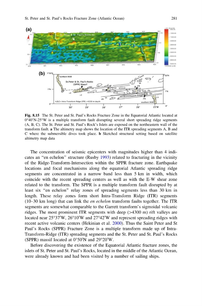
The concentration of seismic epicenters with magnitudes higher than 4 indicates an ‘‘en echelon’’ structure (Rusby 1993) related to fracturing in the vicinity
of the Ridge-Transform-Intersection within the SPPR fracture zone. Earthquake
locations and focal mechanisms along the equatorial Atlantic spreading ridge
segments are concentrated in a narrow band less than 5 km in width, which
coincide with the recent spreading centers as well as with the E-W shear zone
related to the transform. The SPPR is a multiple transform fault disrupted by at
least six ‘‘en echelon’’ relay zones of spreading segments less than 30 km in
length. These relay zones form short Intra-Transform Ridge (ITR) segments
(10–30 km long) that can link the en echelon transform faults together. The ITR
segments are somewhat comparable to the Garrett transform’s sigmoidal volcanic
ridges. The most prominent ITR segments with deep ([4300 m) rift valleys are
located near 25°37
0 W, 26°10
0 W and 27°42
0 W and represent spreading ridges with
recent active volcanic centers (Hekinian et al. 2000). Thus the Saint Peter and St
Paul’s Rocks (SPPR) Fracture Zone is a multiple transform made up of IntraTransform-Ridge (ITR) spreading segments and the St. Peter and St. Paul’s Rocks
(SPPR) massif located at 0°50
0 N and 29°20
0 W.
Before discovering the existence of the Equatorial Atlantic fracture zones, the
islets of St. Peter and St. Paul’s Rocks, located in the middle of the Atlantic Ocean,
were already known and had been visited by a number of sailing ships.
Fig. 8.15 The St. Peter and St. Paul’s Rocks Fracture Zone in the Equatorial Atlantic located at
0°40’N-25°W is a multiple transform fault disrupting several short spreading ridge segments
(A, B, C). The St. Peter and St. Paul’s Rock’s Islets are exposed on the northeastern wall of the
transform fault. a The altimetry map shows the location of the ITR spreading segments A, B and
C where the submersible dives took place. b Sketched structural setting based on satellite
altimetry map data
St. Peter and St. Paul’s Rocks Fracture Zone (Atlantic Ocean)
281
of the Ridge-Transform-Intersection within the SPPR fracture zone. Earthquake
locations and focal mechanisms along the equatorial Atlantic spreading ridge
segments are concentrated in a narrow band less than 5 km in width, which
coincide with the recent spreading centers as well as with the E-W shear zone
related to the transform. The SPPR is a multiple transform fault disrupted by at
least six ‘‘en echelon’’ relay zones of spreading segments less than 30 km in
length. These relay zones form short Intra-Transform Ridge (ITR) segments
(10–30 km long) that can link the en echelon transform faults together. The ITR
segments are somewhat comparable to the Garrett transform’s sigmoidal volcanic
ridges. The most prominent ITR segments with deep ([4300 m) rift valleys are
located near 25°37
0 W, 26°10
0 W and 27°42
0 W and represent spreading ridges with
recent active volcanic centers (Hekinian et al. 2000). Thus the Saint Peter and St
Paul’s Rocks (SPPR) Fracture Zone is a multiple transform made up of IntraTransform-Ridge (ITR) spreading segments and the St. Peter and St. Paul’s Rocks
(SPPR) massif located at 0°50
0 N and 29°20
0 W.
Before discovering the existence of the Equatorial Atlantic fracture zones, the
islets of St. Peter and St. Paul’s Rocks, located in the middle of the Atlantic Ocean,
were already known and had been visited by a number of sailing ships.
Fig. 8.15 The St. Peter and St. Paul’s Rocks Fracture Zone in the Equatorial Atlantic located at
0°40’N-25°W is a multiple transform fault disrupting several short spreading ridge segments
(A, B, C). The St. Peter and St. Paul’s Rock’s Islets are exposed on the northeastern wall of the
transform fault. a The altimetry map shows the location of the ITR spreading segments A, B and
C where the submersible dives took place. b Sketched structural setting based on satellite
altimetry map data
St. Peter and St. Paul’s Rocks Fracture Zone (Atlantic Ocean)
281