

sediment-deprived outcrops are observed. Linear scarps and fresh talus indicates
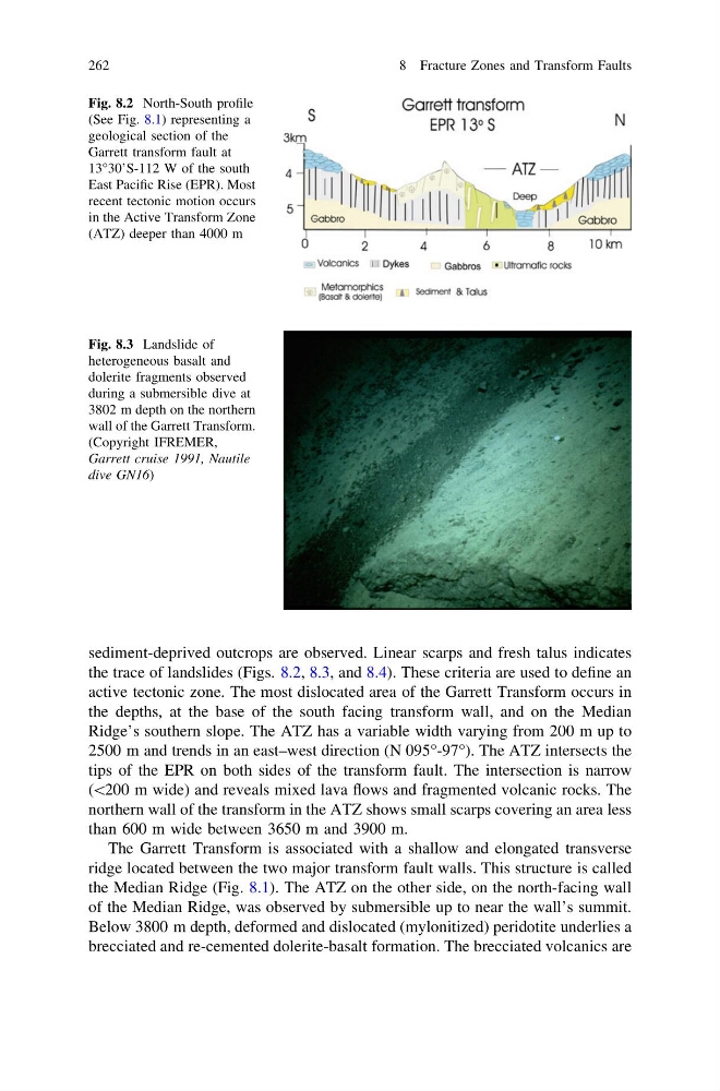
the trace of landslides (Figs. 8.2, 8.3, and 8.4). These criteria are used to define an
active tectonic zone. The most dislocated area of the Garrett Transform occurs in
the depths, at the base of the south facing transform wall, and on the Median
Ridge’s southern slope. The ATZ has a variable width varying from 200 m up to
2500 m and trends in an east–west direction (N 095°-97°). The ATZ intersects the
tips of the EPR on both sides of the transform fault. The intersection is narrow
(\200 m wide) and reveals mixed lava flows and fragmented volcanic rocks. The
northern wall of the transform in the ATZ shows small scarps covering an area less
than 600 m wide between 3650 m and 3900 m.
The Garrett Transform is associated with a shallow and elongated transverse
ridge located between the two major transform fault walls. This structure is called
the Median Ridge (Fig. 8.1). The ATZ on the other side, on the north-facing wall
of the Median Ridge, was observed by submersible up to near the wall’s summit.
Below 3800 m depth, deformed and dislocated (mylonitized) peridotite underlies a
brecciated and re-cemented dolerite-basalt formation. The brecciated volcanics are
Fig. 8.3 Landslide of
heterogeneous basalt and
dolerite fragments observed
during a submersible dive at
3802 m depth on the northern
wall of the Garrett Transform.
(Copyright IFREMER,
Garrett cruise 1991, Nautile
dive GN16)
Fig. 8.2 North-South profile
(See Fig. 8.1) representing a
geological section of the
Garrett transform fault at
13°30’S-112 W of the south
East Pacific Rise (EPR). Most
recent tectonic motion occurs
in the Active Transform Zone
(ATZ) deeper than 4000 m
262
8 Fracture Zones and Transform Faults
the trace of landslides (Figs. 8.2, 8.3, and 8.4). These criteria are used to define an
active tectonic zone. The most dislocated area of the Garrett Transform occurs in
the depths, at the base of the south facing transform wall, and on the Median
Ridge’s southern slope. The ATZ has a variable width varying from 200 m up to
2500 m and trends in an east–west direction (N 095°-97°). The ATZ intersects the
tips of the EPR on both sides of the transform fault. The intersection is narrow
(\200 m wide) and reveals mixed lava flows and fragmented volcanic rocks. The
northern wall of the transform in the ATZ shows small scarps covering an area less
than 600 m wide between 3650 m and 3900 m.
The Garrett Transform is associated with a shallow and elongated transverse
ridge located between the two major transform fault walls. This structure is called
the Median Ridge (Fig. 8.1). The ATZ on the other side, on the north-facing wall
of the Median Ridge, was observed by submersible up to near the wall’s summit.
Below 3800 m depth, deformed and dislocated (mylonitized) peridotite underlies a
brecciated and re-cemented dolerite-basalt formation. The brecciated volcanics are
Fig. 8.3 Landslide of
heterogeneous basalt and
dolerite fragments observed
during a submersible dive at
3802 m depth on the northern
wall of the Garrett Transform.
(Copyright IFREMER,
Garrett cruise 1991, Nautile
dive GN16)
Fig. 8.2 North-South profile
(See Fig. 8.1) representing a
geological section of the
Garrett transform fault at
13°30’S-112 W of the south
East Pacific Rise (EPR). Most
recent tectonic motion occurs
in the Active Transform Zone
(ATZ) deeper than 4000 m
262
8 Fracture Zones and Transform Faults