

some deep towed SEAMARK imagery from America. Jeff Fox from LGO
(Lamont-Doherty Geological Observatory, New York) had kindly provided us
with this information prior to the preparation of our cruise. In addition, other more
localized topographic data on samples dredged from previous U.S and German
cruises (FS SONNE in 1980, Geometep cruise) were made available to us. I was
very thankful to my colleagues John Sinton (University of Hawaii) and Harold
Bäcker from Germany with whom I had shared fruitful discussions on the geology
of the area.
Rejean Hébert from the University of Laval in Canada was also one of my PhD
students at UBO-IFREMER. In 1983, he started to study the samples obtained
from Harold Bäcker and published his results in an international scientific journal
prior to our cruise. The result of his work showed that the ultramafic rocks had
undergone deformation that took place in the lower crust and upper mantle. His
findings strongly suggested that we were in the presence of an uplifted lithosphere
accompanied by plastic deformation revealing a layered rock structure. However,
it appeared that the data obtained from surface ships was not going to be sufficient
for understanding what was happening inside the deep trough lying at a depth of
3000–5000 m.
Some important questions remained to be answered such as: Is there evidence
of recent volcanism? How much? Where and in what form is any recent volcanism
located? Can we find evidence of predicted recent volcanic activity on the basis of
the reconstruction of plate motion simply by using the data obtained during
bathymetric coverage, or must we obtain in situ observations to confirm the
presence of this volcanism?
I first submitted our project for the exploration of the Garrett Fracture Zone in
1987, however it took until 1991 before the cruise was finally accepted and
scheduled by the IFREMER administration. At the time, I recall that this project of
exploring a remote area of the south Pacific did not have the support of our
scientific director in Paris. During a departmental meeting, I remember hearing
him say: ‘‘Do you really think this project Garrett is so important?’’ My answer
was obvious: ‘‘I certainly do, and if I did not think it was important, I would not
ask to go’’.
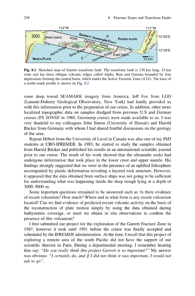
Fig. 8.1 Sketched map of Garrett transform fault. The transform fault is 130 km long, 15 km
wide and has three oblique volcanic ridges called Alpha, Beta and Gamma bounded by four
depressions forming the central basin, which marks the Active Tectonic Zone (ATZ). The trace of
a north–south profile is shown on Fig. 8.2
258
8 Fracture Zones and Transform Faults
(Lamont-Doherty Geological Observatory, New York) had kindly provided us
with this information prior to the preparation of our cruise. In addition, other more
localized topographic data on samples dredged from previous U.S and German
cruises (FS SONNE in 1980, Geometep cruise) were made available to us. I was
very thankful to my colleagues John Sinton (University of Hawaii) and Harold
Bäcker from Germany with whom I had shared fruitful discussions on the geology
of the area.
Rejean Hébert from the University of Laval in Canada was also one of my PhD
students at UBO-IFREMER. In 1983, he started to study the samples obtained
from Harold Bäcker and published his results in an international scientific journal
prior to our cruise. The result of his work showed that the ultramafic rocks had
undergone deformation that took place in the lower crust and upper mantle. His
findings strongly suggested that we were in the presence of an uplifted lithosphere
accompanied by plastic deformation revealing a layered rock structure. However,
it appeared that the data obtained from surface ships was not going to be sufficient
for understanding what was happening inside the deep trough lying at a depth of
3000–5000 m.
Some important questions remained to be answered such as: Is there evidence
of recent volcanism? How much? Where and in what form is any recent volcanism
located? Can we find evidence of predicted recent volcanic activity on the basis of
the reconstruction of plate motion simply by using the data obtained during
bathymetric coverage, or must we obtain in situ observations to confirm the
presence of this volcanism?
I first submitted our project for the exploration of the Garrett Fracture Zone in
1987, however it took until 1991 before the cruise was finally accepted and
scheduled by the IFREMER administration. At the time, I recall that this project of
exploring a remote area of the south Pacific did not have the support of our
scientific director in Paris. During a departmental meeting, I remember hearing
him say: ‘‘Do you really think this project Garrett is so important?’’ My answer
was obvious: ‘‘I certainly do, and if I did not think it was important, I would not
ask to go’’.
Fig. 8.1 Sketched map of Garrett transform fault. The transform fault is 130 km long, 15 km
wide and has three oblique volcanic ridges called Alpha, Beta and Gamma bounded by four
depressions forming the central basin, which marks the Active Tectonic Zone (ATZ). The trace of
a north–south profile is shown on Fig. 8.2
258
8 Fracture Zones and Transform Faults