

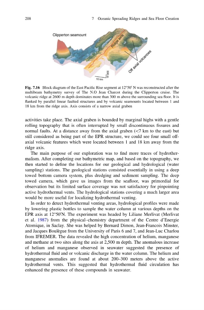
activities take place. The axial graben is bounded by marginal highs with a gentle
rolling topography that is often interrupted by small discontinuous fissures and
normal faults. At a distance away from the axial graben (\7 km to the east) but
still considered as being part of the EPR structure, we could see four small offaxial volcanic features which were located between 1 and 18 km away from the
ridge axis.
The main purpose of our exploration was to find more traces of hydrothermalism. After completing our bathymetric map, and based on the topography, we
then started to define the locations for our geological and hydrological (water
sampling) stations. The geological stations consisted essentially in using a deep
towed bottom camera system, plus dredging and sediment sampling. The deep
towed camera, which gave us images from the seafloor, was primordial for
observation but its limited surface coverage was not satisfactory for pinpointing
active hydrothermal vents. The hydrological stations covering a much larger area
would be more useful for localizing hydrothermal venting.
In order to detect hydrothermal venting areas, hydrological profiles were made
by lowering plastic bottles to sample the water column at various depths on the
EPR axis at 12°50
0 N. The experiment was headed by Liliane Merlivat (Merlivat
et al. 1987) from the physical–chemistry department of the Centre d’Energie
Atomique, in Saclay. She was helped by Bernard Dimon, Jean-Francois Minster,
and Jacques Boulègue from the University of Paris 6 and 7, and Jean-Luc Charlou
from IFREMER. The data revealed the high concentration of helium, manganese
and methane at two sites along the axis at 2,500 m depth. The anomalous increase
of helium and manganese observed in seawater suggested the presence of
hydrothermal fluid and or volcanic discharge in the water column. The helium and
manganese anomalies are found at about 200–300 meters above the active
hydrothermal vents. This suggested that hydrothermal fluid circulation has
enhanced the presence of these compounds in seawater.
Fig. 7.16 Block diagram of the East Pacific Rise segment at 12°50
0 N was reconstructed after the
multibeam bathymetry survey of The N.O Jean Charcot during the Clipperton cruise. The
volcanic ridge at 2600 m depth dominates more than 300 m above the surrounding sea floor. It is
flanked by parallel linear faulted structures and by volcanic seamounts located between 1 and
18 km from the ridge axis. Axis consists of a narrow axial graben
208
7 Oceanic Spreading Ridges and Sea Floor Creation
rolling topography that is often interrupted by small discontinuous fissures and
normal faults. At a distance away from the axial graben (\7 km to the east) but
still considered as being part of the EPR structure, we could see four small offaxial volcanic features which were located between 1 and 18 km away from the
ridge axis.
The main purpose of our exploration was to find more traces of hydrothermalism. After completing our bathymetric map, and based on the topography, we
then started to define the locations for our geological and hydrological (water
sampling) stations. The geological stations consisted essentially in using a deep
towed bottom camera system, plus dredging and sediment sampling. The deep
towed camera, which gave us images from the seafloor, was primordial for
observation but its limited surface coverage was not satisfactory for pinpointing
active hydrothermal vents. The hydrological stations covering a much larger area
would be more useful for localizing hydrothermal venting.
In order to detect hydrothermal venting areas, hydrological profiles were made
by lowering plastic bottles to sample the water column at various depths on the
EPR axis at 12°50
0 N. The experiment was headed by Liliane Merlivat (Merlivat
et al. 1987) from the physical–chemistry department of the Centre d’Energie
Atomique, in Saclay. She was helped by Bernard Dimon, Jean-Francois Minster,
and Jacques Boulègue from the University of Paris 6 and 7, and Jean-Luc Charlou
from IFREMER. The data revealed the high concentration of helium, manganese
and methane at two sites along the axis at 2,500 m depth. The anomalous increase
of helium and manganese observed in seawater suggested the presence of
hydrothermal fluid and or volcanic discharge in the water column. The helium and
manganese anomalies are found at about 200–300 meters above the active
hydrothermal vents. This suggested that hydrothermal fluid circulation has
enhanced the presence of these compounds in seawater.
Fig. 7.16 Block diagram of the East Pacific Rise segment at 12°50
0 N was reconstructed after the
multibeam bathymetry survey of The N.O Jean Charcot during the Clipperton cruise. The
volcanic ridge at 2600 m depth dominates more than 300 m above the surrounding sea floor. It is
flanked by parallel linear faulted structures and by volcanic seamounts located between 1 and
18 km from the ridge axis. Axis consists of a narrow axial graben
208
7 Oceanic Spreading Ridges and Sea Floor Creation