

5 Direct Surface Current Field Imaging from Space
75
order of 5–15 ms and 50–150 ms, respectively, where the lower (higher) values are
for high (low) wind speeds. For a satellite (V ≈ 7 km/s) this translates into maximal
along-track antenna distances between about 35 and 2,100 m for different system
parameters and wind conditions.
While temporal decorrelation at long time lags can lead to a useless quasiuniform phase difference distribution with no recoverable velocity information, a
low signal-to-instrument-noise ratio at short time lags can be reduced by averaging over a sufficient number of independent full-resolution pixel values, since the
instrument-related phase noise is a zero-mean contribution. The number of phase
samples that need to be averaged to obtain velocity estimates with a given accuracy
is a good measure of the data quality of an ATI system, since it describes the relation
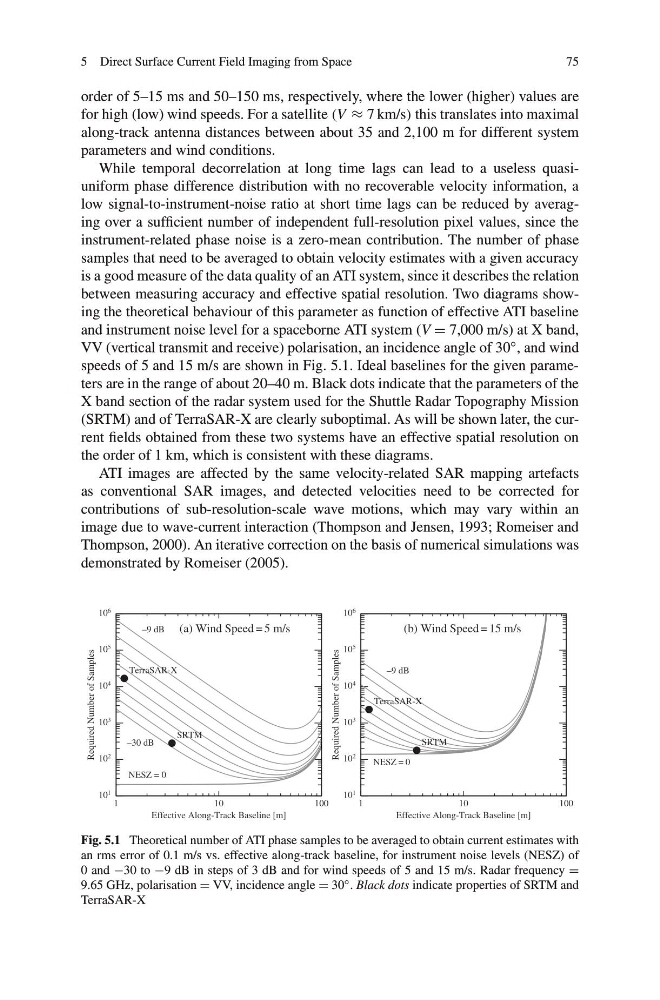
between measuring accuracy and effective spatial resolution. Two diagrams showing the theoretical behaviour of this parameter as function of effective ATI baseline
and instrument noise level for a spaceborne ATI system (V = 7,000 m/s) at X band,
VV (vertical transmit and receive) polarisation, an incidence angle of 30 ◦ , and wind
speeds of 5 and 15 m/s are shown in Fig. 5.1. Ideal baselines for the given parameters are in the range of about 20–40 m. Black dots indicate that the parameters of the
X band section of the radar system used for the Shuttle Radar Topography Mission
(SRTM) and of TerraSAR-X are clearly suboptimal. As will be shown later, the current fields obtained from these two systems have an effective spatial resolution on
the order of 1 km, which is consistent with these diagrams.
ATI images are affected by the same velocity-related SAR mapping artefacts
as conventional SAR images, and detected velocities need to be corrected for
contributions of sub-resolution-scale wave motions, which may vary within an
image due to wave-current interaction (Thompson and Jensen, 1993; Romeiser and
Thompson, 2000). An iterative correction on the basis of numerical simulations was
demonstrated by Romeiser (2005).
1
10
100
Effective Along-Track Baseline [m]
10 1
10 2
10 3
10 4
10 5
10 6
Required Number of Samples
NESZ = 0
–30 dB
–9 dB
SRTM
TerraSAR-X
(a) Wind Speed = 5 m/s
1
1 0
1 0 0
Effective Along-Track Baseline [m]
10 1
10 2
10 3
10 4
10 5
10 6
Required Number of Samples
NESZ = 0
–9 dB
SRTM
TerraSAR-X
(b) Wind Speed = 15 m/s
Fig. 5.1 Theoretical number of ATI phase samples to be averaged to obtain current estimates with
an rms error of 0.1 m/s vs. effective along-track baseline, for instrument noise levels (NESZ) of
0 and −30 to −9 dB in steps of 3 dB and for wind speeds of 5 and 15 m/s. Radar frequency =
9.65 GHz, polarisation = VV, incidence angle = 30 ◦ . Black dots indicate properties of SRTM and
TerraSAR-X
75
order of 5–15 ms and 50–150 ms, respectively, where the lower (higher) values are
for high (low) wind speeds. For a satellite (V ≈ 7 km/s) this translates into maximal
along-track antenna distances between about 35 and 2,100 m for different system
parameters and wind conditions.
While temporal decorrelation at long time lags can lead to a useless quasiuniform phase difference distribution with no recoverable velocity information, a
low signal-to-instrument-noise ratio at short time lags can be reduced by averaging over a sufficient number of independent full-resolution pixel values, since the
instrument-related phase noise is a zero-mean contribution. The number of phase
samples that need to be averaged to obtain velocity estimates with a given accuracy
is a good measure of the data quality of an ATI system, since it describes the relation
between measuring accuracy and effective spatial resolution. Two diagrams showing the theoretical behaviour of this parameter as function of effective ATI baseline
and instrument noise level for a spaceborne ATI system (V = 7,000 m/s) at X band,
VV (vertical transmit and receive) polarisation, an incidence angle of 30 ◦ , and wind
speeds of 5 and 15 m/s are shown in Fig. 5.1. Ideal baselines for the given parameters are in the range of about 20–40 m. Black dots indicate that the parameters of the
X band section of the radar system used for the Shuttle Radar Topography Mission
(SRTM) and of TerraSAR-X are clearly suboptimal. As will be shown later, the current fields obtained from these two systems have an effective spatial resolution on
the order of 1 km, which is consistent with these diagrams.
ATI images are affected by the same velocity-related SAR mapping artefacts
as conventional SAR images, and detected velocities need to be corrected for
contributions of sub-resolution-scale wave motions, which may vary within an
image due to wave-current interaction (Thompson and Jensen, 1993; Romeiser and
Thompson, 2000). An iterative correction on the basis of numerical simulations was
demonstrated by Romeiser (2005).
1
10
100
Effective Along-Track Baseline [m]
10 1
10 2
10 3
10 4
10 5
10 6
Required Number of Samples
NESZ = 0
–30 dB
–9 dB
SRTM
TerraSAR-X
(a) Wind Speed = 5 m/s
1
1 0
1 0 0
Effective Along-Track Baseline [m]
10 1
10 2
10 3
10 4
10 5
10 6
Required Number of Samples
NESZ = 0
–9 dB
SRTM
TerraSAR-X
(b) Wind Speed = 15 m/s
Fig. 5.1 Theoretical number of ATI phase samples to be averaged to obtain current estimates with
an rms error of 0.1 m/s vs. effective along-track baseline, for instrument noise levels (NESZ) of
0 and −30 to −9 dB in steps of 3 dB and for wind speeds of 5 and 15 m/s. Radar frequency =
9.65 GHz, polarisation = VV, incidence angle = 30 ◦ . Black dots indicate properties of SRTM and
TerraSAR-X