

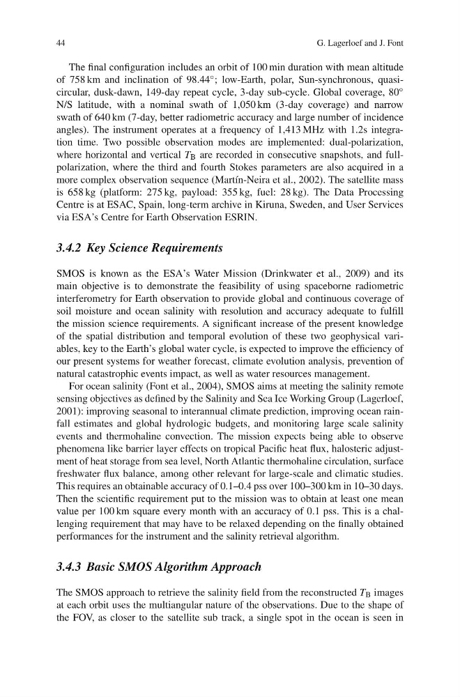
44
G. Lagerloef and J. Font
The final configuration includes an orbit of 100 min duration with mean altitude
of 758 km and inclination of 98.44 ◦ ; low-Earth, polar, Sun-synchronous, quasicircular, dusk-dawn, 149-day repeat cycle, 3-day sub-cycle. Global coverage, 80 ◦
N/S latitude, with a nominal swath of 1,050 km (3-day coverage) and narrow
swath of 640 km (7-day, better radiometric accuracy and large number of incidence
angles). The instrument operates at a frequency of 1,413 MHz with 1.2s integration time. Two possible observation modes are implemented: dual-polarization,
where horizontal and vertical T B are recorded in consecutive snapshots, and fullpolarization, where the third and fourth Stokes parameters are also acquired in a
more complex observation sequence (Martín-Neira et al., 2002). The satellite mass
is 658 kg (platform: 275 kg, payload: 355 kg, fuel: 28 kg). The Data Processing
Centre is at ESAC, Spain, long-term archive in Kiruna, Sweden, and User Services
via ESA’s Centre for Earth Observation ESRIN.
3.4.2 Key Science Requirements
SMOS is known as the ESA’s Water Mission (Drinkwater et al., 2009) and its
main objective is to demonstrate the feasibility of using spaceborne radiometric
interferometry for Earth observation to provide global and continuous coverage of
soil moisture and ocean salinity with resolution and accuracy adequate to fulfill
the mission science requirements. A significant increase of the present knowledge
of the spatial distribution and temporal evolution of these two geophysical variables, key to the Earth’s global water cycle, is expected to improve the efficiency of
our present systems for weather forecast, climate evolution analysis, prevention of
natural catastrophic events impact, as well as water resources management.
For ocean salinity (Font et al., 2004), SMOS aims at meeting the salinity remote
sensing objectives as defined by the Salinity and Sea Ice Working Group (Lagerloef,
2001): improving seasonal to interannual climate prediction, improving ocean rainfall estimates and global hydrologic budgets, and monitoring large scale salinity
events and thermohaline convection. The mission expects being able to observe
phenomena like barrier layer effects on tropical Pacific heat flux, halosteric adjustment of heat storage from sea level, North Atlantic thermohaline circulation, surface
freshwater flux balance, among other relevant for large-scale and climatic studies.
This requires an obtainable accuracy of 0.1–0.4 pss over 100–300 km in 10–30 days.
Then the scientific requirement put to the mission was to obtain at least one mean
value per 100 km square every month with an accuracy of 0.1 pss. This is a challenging requirement that may have to be relaxed depending on the finally obtained
performances for the instrument and the salinity retrieval algorithm.
3.4.3 Basic SMOS Algorithm Approach
The SMOS approach to retrieve the salinity field from the reconstructed T B images
at each orbit uses the multiangular nature of the observations. Due to the shape of
the FOV, as closer to the satellite sub track, a single spot in the ocean is seen in
G. Lagerloef and J. Font
The final configuration includes an orbit of 100 min duration with mean altitude
of 758 km and inclination of 98.44 ◦ ; low-Earth, polar, Sun-synchronous, quasicircular, dusk-dawn, 149-day repeat cycle, 3-day sub-cycle. Global coverage, 80 ◦
N/S latitude, with a nominal swath of 1,050 km (3-day coverage) and narrow
swath of 640 km (7-day, better radiometric accuracy and large number of incidence
angles). The instrument operates at a frequency of 1,413 MHz with 1.2s integration time. Two possible observation modes are implemented: dual-polarization,
where horizontal and vertical T B are recorded in consecutive snapshots, and fullpolarization, where the third and fourth Stokes parameters are also acquired in a
more complex observation sequence (Martín-Neira et al., 2002). The satellite mass
is 658 kg (platform: 275 kg, payload: 355 kg, fuel: 28 kg). The Data Processing
Centre is at ESAC, Spain, long-term archive in Kiruna, Sweden, and User Services
via ESA’s Centre for Earth Observation ESRIN.
3.4.2 Key Science Requirements
SMOS is known as the ESA’s Water Mission (Drinkwater et al., 2009) and its
main objective is to demonstrate the feasibility of using spaceborne radiometric
interferometry for Earth observation to provide global and continuous coverage of
soil moisture and ocean salinity with resolution and accuracy adequate to fulfill
the mission science requirements. A significant increase of the present knowledge
of the spatial distribution and temporal evolution of these two geophysical variables, key to the Earth’s global water cycle, is expected to improve the efficiency of
our present systems for weather forecast, climate evolution analysis, prevention of
natural catastrophic events impact, as well as water resources management.
For ocean salinity (Font et al., 2004), SMOS aims at meeting the salinity remote
sensing objectives as defined by the Salinity and Sea Ice Working Group (Lagerloef,
2001): improving seasonal to interannual climate prediction, improving ocean rainfall estimates and global hydrologic budgets, and monitoring large scale salinity
events and thermohaline convection. The mission expects being able to observe
phenomena like barrier layer effects on tropical Pacific heat flux, halosteric adjustment of heat storage from sea level, North Atlantic thermohaline circulation, surface
freshwater flux balance, among other relevant for large-scale and climatic studies.
This requires an obtainable accuracy of 0.1–0.4 pss over 100–300 km in 10–30 days.
Then the scientific requirement put to the mission was to obtain at least one mean
value per 100 km square every month with an accuracy of 0.1 pss. This is a challenging requirement that may have to be relaxed depending on the finally obtained
performances for the instrument and the salinity retrieval algorithm.
3.4.3 Basic SMOS Algorithm Approach
The SMOS approach to retrieve the salinity field from the reconstructed T B images
at each orbit uses the multiangular nature of the observations. Due to the shape of
the FOV, as closer to the satellite sub track, a single spot in the ocean is seen in